
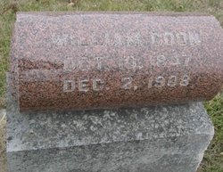
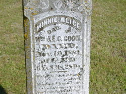
William Coon
| Birth | : | 10 Oct 1847 Henry County, Indiana, USA |
| Death | : | 2 Dec 1908 Osceola, Clarke County, Iowa, USA |
| Burial | : | Hite Cemetery, Biggers, Randolph County, USA |
| Coordinate | : | 36.2985990, -90.8198230 |
frequently asked questions (FAQ):
-
Where is William Coon's memorial?
William Coon's memorial is located at: Hite Cemetery, Biggers, Randolph County, USA.
-
When did William Coon death?
William Coon death on 2 Dec 1908 in Osceola, Clarke County, Iowa, USA
-
Where are the coordinates of the William Coon's memorial?
Latitude: 36.2985990
Longitude: -90.8198230
Family Members:
Parent

Spouse
Siblings


Children
Flowers:


Nearby Cemetories:
1. Hite Cemetery
Biggers, Randolph County, USA
Coordinate: 36.2985990, -90.8198230
2. Dunn Cemetery #2
Biggers, Randolph County, USA
Coordinate: 36.2916900, -90.8316900
3. Shaver Cemetery
Randolph County, USA
Coordinate: 36.3034800, -90.8404100
4. Johnson-McIlroy Cemetery
Randolph County, USA
Coordinate: 36.2972400, -90.8421800
5. Luttrell Cemetery
Biggers, Randolph County, USA
Coordinate: 36.3120100, -90.8014300
6. Sparkman Cemetery
Biggers, Randolph County, USA
Coordinate: 36.3048500, -90.8441700
7. Yellow Hall Cemetery
Biggers, Randolph County, USA
Coordinate: 36.3258018, -90.8283005
8. Lawnbird Cemetery
Biggers, Randolph County, USA
Coordinate: 36.3177986, -90.7932968
9. Brimmage Cemetery
Randolph County, USA
Coordinate: 36.2801100, -90.8485500
10. Scott Cemetery
Biggers, Randolph County, USA
Coordinate: 36.3300018, -90.8139038
11. Osborn Cemetery
Biggers, Randolph County, USA
Coordinate: 36.3320800, -90.7875000
12. Cherry Cemetery
Randolph County, USA
Coordinate: 36.3222008, -90.7592010
13. Old Reyno Cemetery
Randolph County, USA
Coordinate: 36.3314018, -90.7592010
14. Blount Cemetery
Reyno, Randolph County, USA
Coordinate: 36.3518982, -90.7718964
15. Albrite Cemetery
Greene County, USA
Coordinate: 36.2630997, -90.7482986
16. Johnston Cemetery
Reyno, Randolph County, USA
Coordinate: 36.3568993, -90.7716980
17. Serge Cemetery (Defunct)
Randolph County, USA
Coordinate: 36.2303009, -90.8432999
18. Liberty Cemetery
Randolph County, USA
Coordinate: 36.2207985, -90.8542023
19. Sharum Cemetery
Pocahontas, Randolph County, USA
Coordinate: 36.2207985, -90.8544006
20. Saint John Cemetery
Engelberg, Randolph County, USA
Coordinate: 36.3396988, -90.9092026
21. Brooks Burial Plot
Sharum, Randolph County, USA
Coordinate: 36.2225300, -90.8618400
22. Nelson Clay Cemetery
Clay County, USA
Coordinate: 36.3576800, -90.7396700
23. Davis Cemetery
Engelberg, Randolph County, USA
Coordinate: 36.3513985, -90.9085999
24. Brownie Chapel Cemetery
Peach Orchard, Clay County, USA
Coordinate: 36.2706200, -90.7085200