
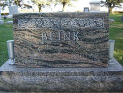


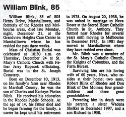
William Cyril “Bill” Blink
| Birth | : | 10 Dec 1913 Marshall County, Iowa, USA |
| Death | : | 21 Dec 1998 Marshalltown, Marshall County, Iowa, USA |
| Burial | : | Canton Baptist Church Cemetery, Canton, Salem County, USA |
| Coordinate | : | 39.4799385, -75.4120789 |
| Description | : | Bill started to farm at the age of sixteen, when his father died in 1929. He and his wife retired from the farm on December 2, 1975 and moved to Melbourne where they lived until April 10, 1981 when their home was destroyed by a tornado. Then they settled in Marshalltown. 2nd of two children MARRIED: 8/19/1938, St.Anthony's Catholic Church, St. Anthony, Marshall County, IA, Neva Matilda Doser, 9/29/1910 - CHILDREN: Robert Lee, 5/8/1943 - & Donald, 9/4/1954 - |
frequently asked questions (FAQ):
-
Where is William Cyril “Bill” Blink's memorial?
William Cyril “Bill” Blink's memorial is located at: Canton Baptist Church Cemetery, Canton, Salem County, USA.
-
When did William Cyril “Bill” Blink death?
William Cyril “Bill” Blink death on 21 Dec 1998 in Marshalltown, Marshall County, Iowa, USA
-
Where are the coordinates of the William Cyril “Bill” Blink's memorial?
Latitude: 39.4799385
Longitude: -75.4120789
Family Members:
Parent
Spouse

Children
Flowers:


Nearby Cemetories:
1. Canton Baptist Church Cemetery
Canton, Salem County, USA
Coordinate: 39.4799385, -75.4120789
2. Cuff Cemetery
Canton, Salem County, USA
Coordinate: 39.4649391, -75.4077988
3. Cedar Hill Friends Cemetery
Harmersville, Salem County, USA
Coordinate: 39.5014720, -75.4387800
4. Hancocks Bridge United Methodist Church Cemetery
Harmersville, Salem County, USA
Coordinate: 39.5023537, -75.4411850
5. Battle of Quintons Bridge Graveyard
Quinton, Salem County, USA
Coordinate: 39.5130650, -75.3884040
6. Berrys Chapel Cemetery
Quinton, Salem County, USA
Coordinate: 39.5137900, -75.3779510
7. Alloway Creek Old Quaker Burial Ground
Lower Alloways Creek Township, Salem County, USA
Coordinate: 39.5202900, -75.4597000
8. Marlboro Seventh Day Baptist Church Cemetery
Marlboro, Cumberland County, USA
Coordinate: 39.4899200, -75.3259500
9. Mill Hollow Cemetery
Quinton, Salem County, USA
Coordinate: 39.5563120, -75.4305770
10. Ambury Hill Cemetery
Cumberland County, USA
Coordinate: 39.4175491, -75.3496552
11. Greenwich Presbyterian Church Cemetery
Greenwich, Cumberland County, USA
Coordinate: 39.4126200, -75.3459800
12. Evergreen Cemetery
Salem, Salem County, USA
Coordinate: 39.5540000, -75.4652000
13. Mount Pisgah AME Cemetery
Salem County, USA
Coordinate: 39.5549700, -75.4663900
14. Cohansey Baptist Church Cemetery
Roadstown, Cumberland County, USA
Coordinate: 39.4388630, -75.3143070
15. Alloway Baptist Church Cemetery
Alloway, Salem County, USA
Coordinate: 39.5606308, -75.3655090
16. Mount Pleasant Cemetery
Springtown, Cumberland County, USA
Coordinate: 39.4182663, -75.3290863
17. Othello Church Graveyard
Othello, Cumberland County, USA
Coordinate: 39.4182660, -75.3290860
18. East View Cemetery
Salem, Salem County, USA
Coordinate: 39.5627480, -75.4561081
19. Greenwich Friends Meeting House Cemetery
Greenwich, Cumberland County, USA
Coordinate: 39.4066467, -75.3447189
20. Baptist Cemetery
Salem, Salem County, USA
Coordinate: 39.5621681, -75.4611053
21. Alloway United Methodist Church Cemetery
Alloway, Salem County, USA
Coordinate: 39.5623207, -75.3586273
22. Shiloh Seventh Day Baptist Church Cemetery
Shiloh, Cumberland County, USA
Coordinate: 39.4591293, -75.2956696
23. Old Alloway Cemetery
Alloway, Salem County, USA
Coordinate: 39.5619545, -75.3549957
24. Mount Hope United Methodist Church Cemetery
Salem, Salem County, USA
Coordinate: 39.5660667, -75.4606781