
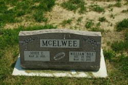

William Gale “Bill” McElwee
| Birth | : | 28 Dec 1931 Henry County, Iowa, USA |
| Death | : | 14 Mar 2012 Mount Pleasant, Henry County, Iowa, USA |
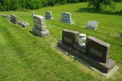
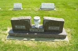
| Burial | : | Lambirth Cemetery, Henry County, USA |
| Coordinate | : | 40.9230995, -91.7149963 |
| Description | : | William "Bill" Gale McElwee, 80, of Mount Pleasant died Wednesday, March 14, 2012, at Arbor Court in Mount Pleasant due to complications related to Alzheimer's. Born Dec. 28, 1931, in rural Henry County, he was the son of Thomas and Mary Barton McElwee. On June 26, 1955, he married Joyce Elizabeth Hourihan in Salem. Mr. McElwee and his wife farmed in Henry County, and he operated a road grader for Henry County Secondary Roads Department. He attended grade school in rural Jefferson County and graduated from Mount Pleasant High School. He served in the Army from 1951 to 1955 during... Read More |
frequently asked questions (FAQ):
-
Where is William Gale “Bill” McElwee's memorial?
William Gale “Bill” McElwee's memorial is located at: Lambirth Cemetery, Henry County, USA.
-
When did William Gale “Bill” McElwee death?
William Gale “Bill” McElwee death on 14 Mar 2012 in Mount Pleasant, Henry County, Iowa, USA
-
Where are the coordinates of the William Gale “Bill” McElwee's memorial?
Latitude: 40.9230995
Longitude: -91.7149963
Family Members:
Parent
Flowers:


Nearby Cemetories:
1. Lambirth Cemetery
Henry County, USA
Coordinate: 40.9230995, -91.7149963
2. Crane Cemetery
Glasgow, Jefferson County, USA
Coordinate: 40.9250189, -91.7279368
3. Gilmer Cemetery
Jefferson County, USA
Coordinate: 40.9486008, -91.7564011
4. Hickory Grove Cemetery
Van Buren County, USA
Coordinate: 40.8869019, -91.7469025
5. Pleasant Point Cemetery
Henry County, USA
Coordinate: 40.9448000, -91.6545000
6. Upland Cemetery
Lockridge, Jefferson County, USA
Coordinate: 40.9700012, -91.7461014
7. Smith Family Burial Site
Mount Pleasant, Henry County, USA
Coordinate: 40.9755300, -91.6987500
8. Glasgow Cemetery
Glasgow, Jefferson County, USA
Coordinate: 40.9375000, -91.7838974
9. Grant Cemetery
Rome, Henry County, USA
Coordinate: 40.9880981, -91.6992035
10. Cedar Creek Cemetery
Salem, Henry County, USA
Coordinate: 40.8983002, -91.6307983
11. Hopkirk Family Cemetery
Lockridge, Jefferson County, USA
Coordinate: 40.9928820, -91.7396530
12. Oakland Mills Cemetery
Oakland Mills, Henry County, USA
Coordinate: 40.9340000, -91.6183000
13. Sample Cemetery
Henry County, USA
Coordinate: 40.9812000, -91.6528000
14. Jones Family Cemetery
Jefferson County, USA
Coordinate: 40.9302000, -91.8164000
15. Spencer Cemetery
Stockport, Van Buren County, USA
Coordinate: 40.8792000, -91.8007965
16. Lockridge Cemetery
Lockridge, Jefferson County, USA
Coordinate: 40.9952000, -91.7558500
17. Mount Zion Cemetery
Jefferson County, USA
Coordinate: 40.9617004, -91.8082962
18. Hopkirk Cemetery
Jefferson County, USA
Coordinate: 41.0029000, -91.7566000
19. Fiedler Cemetery
Glasgow, Jefferson County, USA
Coordinate: 40.9321000, -91.8280000
20. Short Family Burials
Henry County, USA
Coordinate: 40.9352500, -91.6019800
21. Bonnifield Cemetery
Lockridge, Jefferson County, USA
Coordinate: 40.9874992, -91.7966995
22. Faulkner Cemetery
Oakland Mills, Henry County, USA
Coordinate: 40.9207000, -91.5966000
23. Hillsboro Cemetery
Hillsboro, Henry County, USA
Coordinate: 40.8310400, -91.7145000
24. New Swedish Methodist Church Cemetery
Jefferson County, USA
Coordinate: 41.0037384, -91.7763519