
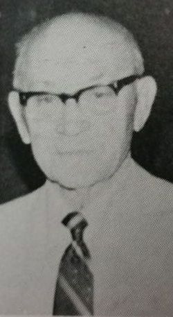
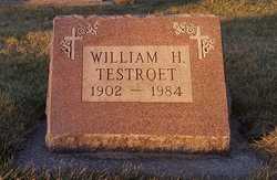
William H. “Bill" "Muddy” Testroet
| Birth | : | 23 Dec 1902 Templeton, Carroll County, Iowa, USA |
| Death | : | 24 May 1984 Carroll, Carroll County, Iowa, USA |
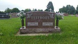
| Burial | : | Saint Augustine Cemetery, Halbur, Carroll County, USA |
| Coordinate | : | 42.0066986, -94.9744034 |
| Description | : | Halbur U. founder Testroet dies at age 81 William H. (Muddy) Testroet, 81, of Westwood Knolls 2239 North West street, died Thursday, May 24, at St. Anthony Regional Hospital. He was a retired farmer who moved from Halbur to Carroll in 1974. He pioneered the Halbur University Scholarship Corpration in 1975, helping many young people from the area to further their education beyond high school. He served as president of the mythical Halbur University from 197_ to 1981. Mass of the Christian Burial will be celebrated at 1 p.m. Tuesday, May 29, at St. Lawrence Church. Mrs. Michael (Helen) Ovellette... Read More |
frequently asked questions (FAQ):
-
Where is William H. “Bill" "Muddy” Testroet's memorial?
William H. “Bill" "Muddy” Testroet's memorial is located at: Saint Augustine Cemetery, Halbur, Carroll County, USA.
-
When did William H. “Bill" "Muddy” Testroet death?
William H. “Bill" "Muddy” Testroet death on 24 May 1984 in Carroll, Carroll County, Iowa, USA
-
Where are the coordinates of the William H. “Bill" "Muddy” Testroet's memorial?
Latitude: 42.0066986
Longitude: -94.9744034
Family Members:
Parent
Siblings

Flowers:


Nearby Cemetories:
1. Saint Augustine Cemetery
Halbur, Carroll County, USA
Coordinate: 42.0066986, -94.9744034
2. Holy Angels Cemetery
Carroll County, USA
Coordinate: 42.0014000, -94.9141998
3. Saint Johns Catholic Cemetery
Arcadia, Carroll County, USA
Coordinate: 42.0855406, -95.0341577
4. Saint Francis Cemetery
Maple River, Carroll County, USA
Coordinate: 42.0969009, -94.9372025
5. Sacred Heart Cemetery
Templeton, Carroll County, USA
Coordinate: 41.9138746, -94.9460994
6. Mount Olivet Cemetery
Carroll, Carroll County, USA
Coordinate: 42.0536340, -94.8595510
7. Arcadia Cemetery
Arcadia Township, Carroll County, USA
Coordinate: 42.1000680, -95.0130550
8. Carroll City Cemetery
Carroll, Carroll County, USA
Coordinate: 42.0560963, -94.8599856
9. Westside Cemetery
Westside, Crawford County, USA
Coordinate: 42.0602989, -95.0922012
10. Hayes Township Cemetery
Westside, Crawford County, USA
Coordinate: 42.0083199, -95.1216583
11. Elba Cemetery
Templeton, Carroll County, USA
Coordinate: 41.9068985, -94.9131012
12. Sacred Heart Cemetery
Manning, Carroll County, USA
Coordinate: 41.9132500, -95.0540000
13. Saint Marys Catholic Cemetery
Willey, Carroll County, USA
Coordinate: 41.9783363, -94.8212204
14. Manning Cemetery
Manning, Carroll County, USA
Coordinate: 41.8990000, -95.0620000
15. Iowa Township Cemetery
Aspinwall, Crawford County, USA
Coordinate: 41.9216995, -95.1113968
16. Our Lady Of Mount Carmel Cemetery
Mount Carmel, Carroll County, USA
Coordinate: 42.1547012, -94.9088974
17. Dedham Cemetery
Dedham, Carroll County, USA
Coordinate: 41.8993988, -94.8225021
18. Saint Josephs Cemetery
Dedham, Carroll County, USA
Coordinate: 41.8993988, -94.8210983
19. Saint Anns Cemetery
Vail, Crawford County, USA
Coordinate: 42.0513992, -95.1868973
20. Gray Cemetery
Gray, Audubon County, USA
Coordinate: 41.8414001, -94.9946976
21. McCurdy Cemetery
Carroll County, USA
Coordinate: 41.9403000, -94.7649994
22. Saint Bernards Cemetery
Breda, Carroll County, USA
Coordinate: 42.1786003, -94.9732971
23. Holy Family Cemetery
Lidderdale, Carroll County, USA
Coordinate: 42.1178017, -94.7839966
24. West Lawn Cemetery
Glidden, Carroll County, USA
Coordinate: 42.0649986, -94.7406006