
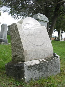
William H Howenstine
| Birth | : | 28 Jul 1833 Ohio, USA |
| Death | : | 21 Nov 1901 Whitley County, Indiana, USA |
| Burial | : | Curtis Cemetery, Bronson, Branch County, USA |
| Coordinate | : | 41.8039017, -85.1956024 |
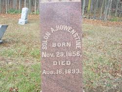
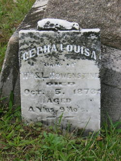
| Description | : | William H Howenstine and his wife Lydia (Kimmel) Howenstine are buried at Evergreen Cemetery, next to two of their children; son Solon and daughter Cepha Louisa. The west face of their gravestone is engraved: --- Wm H HOWENSTINE JULY 28, 1833 - NOV 21, 1901 --- LYDIA His Wife JAN 6, 1834 - MAR 30, 1906 The GPS location for this grave is Lat. 41° 3' 36.1" North and Long. 85° 26' 15.2" West. |
frequently asked questions (FAQ):
-
Where is William H Howenstine's memorial?
William H Howenstine's memorial is located at: Curtis Cemetery, Bronson, Branch County, USA.
-
When did William H Howenstine death?
William H Howenstine death on 21 Nov 1901 in Whitley County, Indiana, USA
-
Where are the coordinates of the William H Howenstine's memorial?
Latitude: 41.8039017
Longitude: -85.1956024
Family Members:
Parent
Spouse

Siblings
Children
Flowers:


Nearby Cemetories:
1. Curtis Cemetery
Bronson, Branch County, USA
Coordinate: 41.8039017, -85.1956024
2. Pleasant Hill Cemetery
Noble Township, Branch County, USA
Coordinate: 41.7961110, -85.2111110
3. North Gilead Cemetery
Gilead Township, Branch County, USA
Coordinate: 41.8039017, -85.1557999
4. South Gilead Cemetery
Bronson, Branch County, USA
Coordinate: 41.7733330, -85.1566670
5. Dutch Settlement Cemetery
Bronson, Branch County, USA
Coordinate: 41.8106003, -85.2632980
6. Saint Marys Cemetery
Bronson, Branch County, USA
Coordinate: 41.8582993, -85.1939011
7. Trayer Cemetery
Bronson, Branch County, USA
Coordinate: 41.7705550, -85.2677770
8. Bronson Cemetery
Bronson, Branch County, USA
Coordinate: 41.8699340, -85.1858320
9. Adams Cemetery
Bronson, Branch County, USA
Coordinate: 41.8405991, -85.2767029
10. Mill Grove Cemetery
Orland, Steuben County, USA
Coordinate: 41.7327995, -85.1718979
11. Greenlawn Cemetery
Orland, Steuben County, USA
Coordinate: 41.7338982, -85.1594009
12. Snow Prairie Cemetery
Bethel, Branch County, USA
Coordinate: 41.8699989, -85.1408005
13. Carleton Cemetery
Orland, Steuben County, USA
Coordinate: 41.7369890, -85.1403120
14. East Gilead Cemetery
East Gilead, Branch County, USA
Coordinate: 41.7858330, -85.0825000
15. Fillmore Family Cemetery
Greenfield Mills, LaGrange County, USA
Coordinate: 41.7219260, -85.2347090
16. Freedom Cemetery
Fawn River, St. Joseph County, USA
Coordinate: 41.8064003, -85.3371964
17. Eroh Cemetery
Fawn River Township, St. Joseph County, USA
Coordinate: 41.8081017, -85.3375015
18. Card Cemetery
Bethel Township, Branch County, USA
Coordinate: 41.8544006, -85.0693970
19. York Cemetery
Batavia, Branch County, USA
Coordinate: 41.9009350, -85.1318550
20. Burr Oak Township Cemetery
Burr Oak, St. Joseph County, USA
Coordinate: 41.8472214, -85.3319473
21. Bartholomew Cemetery
Fawn River Township, St. Joseph County, USA
Coordinate: 41.8059600, -85.3476300
22. Fawn River Township Cemetery
Fawn River, St. Joseph County, USA
Coordinate: 41.7819440, -85.3475040
23. Eagle Cemetery
LaGrange County, USA
Coordinate: 41.7313200, -85.3162200
24. Robinson Family Cemetery
Orland, Steuben County, USA
Coordinate: 41.6927030, -85.1412750