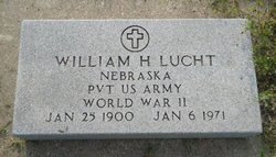
William H Lucht
| Birth | : | 25 Jan 1900 Wolbach, Greeley County, Nebraska, USA |
| Death | : | 6 Jan 1971 Tonopah, Nye County, Nevada, USA |
| Burial | : | Elmwood Cemetery, Saint Paul, Howard County, USA |
| Coordinate | : | 41.2002983, -98.4677963 |
| Plot | : | 830 |
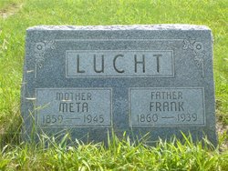
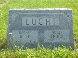
| Description | : | The Wolbach Messenger, January 14, 1971, page 1, transcribed by Linda Berney: William H. Lucht was born January 25, 1900 near Wolbach to Frank and Meta Taddiken Lucht, and was baptized into the Lutheran faith. He received his education and grew to manhood in the Cushing area. He was married to Clara Edelman on August 15, 1925. For a number of years, Mr. Lucht worked for the Burlington Railroad in Nebraska, Wyoming and Colorado. In 1932 he entered into mining in Old Mexico and later in California, Arizona and Nevada, In 1957 he worked in radar for the... Read More |
frequently asked questions (FAQ):
-
Where is William H Lucht's memorial?
William H Lucht's memorial is located at: Elmwood Cemetery, Saint Paul, Howard County, USA.
-
When did William H Lucht death?
William H Lucht death on 6 Jan 1971 in Tonopah, Nye County, Nevada, USA
-
Where are the coordinates of the William H Lucht's memorial?
Latitude: 41.2002983
Longitude: -98.4677963
Family Members:
Parent
Spouse
Siblings
Flowers:
Nearby Cemetories:
1. Elmwood Cemetery
Saint Paul, Howard County, USA
Coordinate: 41.2002983, -98.4677963
2. Warsaw Cemetery
Saint Paul, Howard County, USA
Coordinate: 41.1844400, -98.5575000
3. Canada Hill Methodist Episcopal Cemetery
Howard County, USA
Coordinate: 41.1843987, -98.5575027
4. Saint Wenceslaus Cemetery
Howard County, USA
Coordinate: 41.2056007, -98.5702972
5. Hamm Cemetery
Howard County, USA
Coordinate: 41.2933006, -98.4672012
6. Fairdale Cemetery
Howard County, USA
Coordinate: 41.2891998, -98.5152969
7. Elba Cemetery
Elba, Howard County, USA
Coordinate: 41.2764015, -98.5643997
8. Oak Ridge Cemetery
Dannebrog, Howard County, USA
Coordinate: 41.1138992, -98.5485992
9. Bohemian National Graveyard
Howard County, USA
Coordinate: 41.2492070, -98.5927620
10. Scotch Cemetery
Farwell, Howard County, USA
Coordinate: 41.1917000, -98.6130981
11. Czechoslovakia Cemetery
Farwell, Howard County, USA
Coordinate: 41.2132988, -98.6224976
12. Saint Josephs Cemetery
Elba, Howard County, USA
Coordinate: 41.2930984, -98.5746994
13. South Logan Cemetery
Howard County, USA
Coordinate: 41.3222100, -98.4352600
14. North Cemetery
Howard County, USA
Coordinate: 41.3222008, -98.4347000
15. Danish Lutheran Cemetery
Farwell, Howard County, USA
Coordinate: 41.2134660, -98.6336020
16. Nysted Cemetery
Nysted, Howard County, USA
Coordinate: 41.1307983, -98.6136017
17. Saint Anthony Catholic Cemetery
Farwell, Howard County, USA
Coordinate: 41.1845400, -98.6414700
18. Saint Libory Catholic Cemetery
Saint Libory, Howard County, USA
Coordinate: 41.0828700, -98.3569700
19. Spring Creek Cemetery
Cushing, Howard County, USA
Coordinate: 41.3314200, -98.3833300
20. Rose Hill Cemetery
Palmer, Merrick County, USA
Coordinate: 41.2256012, -98.2692032
21. Haggart Cemetery
Saint Libory, Howard County, USA
Coordinate: 41.0698500, -98.3547500
22. Kelso Cemetery
Howard County, USA
Coordinate: 41.1627998, -98.6707993
23. Fairdale Sunrise Cemetery
Elba, Howard County, USA
Coordinate: 41.3580000, -98.4887000
24. Swedish Pioneer Cemetery
Howard County, USA
Coordinate: 41.0910988, -98.6324997

