William Harvey Caswell
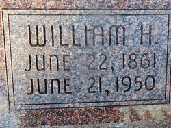
| Birth | : | 22 Jun 1861 Hart County, Kentucky, USA |
| Death | : | 21 Jun 1950 Pawnee City, Pawnee County, Nebraska, USA |
| Burial | : | Stone Mills Cemetery, Stone Mills, Jefferson County, USA |
| Coordinate | : | 44.1150000, -75.9741800 |
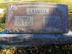
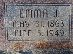
| Description | : | Son of Francis M. & Nancy Jane Smith Caswell. Married to Emma Jane DeWitt on Oct. 3, 1880 at Cincinnati, Pawnee County, Nebraska. (Pawnee Library, book of obits in the Pawnee Republican.) (Pawnee Republican, June 29, 1950) WILLIAM HARVEY CASWELL William Harvey Caswell, son of Nancy Jane and Francis Caswell, was born in Harts County, Kentucky, on June 22, 1861, and passed away at the Pawnee County hospital on June 21, 1950, at the age of 88 years, 11 months, and 29 days. On Oct. 10, 1880, he was united in marriage to Emma Jane DeWitt,and to this union 11 children were born, two dying in... Read More |
frequently asked questions (FAQ):
-
Where is William Harvey Caswell's memorial?
William Harvey Caswell's memorial is located at: Stone Mills Cemetery, Stone Mills, Jefferson County, USA.
-
When did William Harvey Caswell death?
William Harvey Caswell death on 21 Jun 1950 in Pawnee City, Pawnee County, Nebraska, USA
-
Where are the coordinates of the William Harvey Caswell's memorial?
Latitude: 44.1150000
Longitude: -75.9741800
Family Members:
Parent
Spouse
Siblings
Children
Flowers:
Nearby Cemetories:
1. Stone Mills Cemetery
Stone Mills, Jefferson County, USA
Coordinate: 44.1150000, -75.9741800
2. Rouses Cemetery
Jefferson County, USA
Coordinate: 44.1161003, -75.9925003
3. Mitchell Family Cemetery
Stone Mills, Jefferson County, USA
Coordinate: 44.1290210, -75.9659020
4. Gunns Corner Cemetery
Clayton, Jefferson County, USA
Coordinate: 44.1002830, -75.9956440
5. Allen Family Cemetery
Brownville, Jefferson County, USA
Coordinate: 44.0796200, -75.9881900
6. Parrish Cemetery
Jefferson County, USA
Coordinate: 44.0744019, -75.9393997
7. Perch River Cemetery
Brownville, Jefferson County, USA
Coordinate: 44.0741692, -76.0094376
8. Epps Settlement Cemetery
Clayton, Jefferson County, USA
Coordinate: 44.1627700, -76.0083500
9. Dutch Gap Lutheran Cemetery
Jefferson County, USA
Coordinate: 44.1627998, -76.0083008
10. Old Depauville Cemetery
Depauville, Jefferson County, USA
Coordinate: 44.1383300, -76.0630600
11. Perch Lake Cemetery
Jefferson County, USA
Coordinate: 44.1286011, -75.8796997
12. Stevens Cemetery
Jefferson County, USA
Coordinate: 44.0461006, -75.9608002
13. New Depauville Memorial Cemetery
Depauville, Jefferson County, USA
Coordinate: 44.1397200, -76.0653300
14. Grove Cemetery
La Fargeville, Jefferson County, USA
Coordinate: 44.1857986, -75.9736023
15. Adam Flath Burial Ground
Jefferson County, USA
Coordinate: 44.0933300, -75.8708600
16. Taylor Cemetery
Brownville, Jefferson County, USA
Coordinate: 44.0368996, -75.9661026
17. Freeman Cemetery
Brownville, Jefferson County, USA
Coordinate: 44.0833015, -76.0742035
18. Corbin Cemetery
Jefferson County, USA
Coordinate: 44.1528015, -76.0757980
19. Clayton Center Cemetery
Clayton Center, Jefferson County, USA
Coordinate: 44.1918700, -76.0402800
20. Pettit Cemetery
Brownville, Jefferson County, USA
Coordinate: 44.0222015, -75.9524994
21. Orleans Cemetery
Orleans Four Corners, Jefferson County, USA
Coordinate: 44.2043991, -75.9064026
22. Beech Ridge Cemetery
Jefferson County, USA
Coordinate: 44.2167015, -75.9633026
23. Limerick Cemetery
Brownville, Jefferson County, USA
Coordinate: 44.0264300, -76.0467100
24. Three Mile Creek Cemetery
Clayton, Jefferson County, USA
Coordinate: 44.1533012, -76.1085968

