
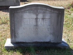
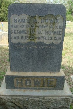
William Henry Howie
| Birth | : | 31 Oct 1838 Mecklenburg County, North Carolina, USA |
| Death | : | 2 Jan 1925 Waxhaw, Union County, North Carolina, USA |
| Burial | : | Ong Cemetery, Ong, Clay County, USA |
| Coordinate | : | 40.4077988, -97.8367004 |
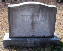
| Description | : | - William Henry Howie married Mary Bell "Mittie" Krauss (a widow) on March 23, 1904 according to the Widow's Application For Confederate Pension for her pension for her late husband dated April 21, 1937. Also the 1900 census for Sandy Ridge Township of Union County, NC lists WHH Sr as age 61 and widowed. The 1910 census list WHH as age 71 and married. Provided by Edwina Eubanks 48790473 - William Henry Howie (Union County) [Source: NC State Archives Call #5.22.209.65] Pension Bureau: Act of 1901 Pension Applications Soldier served in the South Carolina State Troops. Widow... Read More |
frequently asked questions (FAQ):
-
Where is William Henry Howie's memorial?
William Henry Howie's memorial is located at: Ong Cemetery, Ong, Clay County, USA.
-
When did William Henry Howie death?
William Henry Howie death on 2 Jan 1925 in Waxhaw, Union County, North Carolina, USA
-
Where are the coordinates of the William Henry Howie's memorial?
Latitude: 40.4077988
Longitude: -97.8367004
Family Members:
Parent
Spouse

Siblings
Children

Flowers:


Nearby Cemetories:
1. Ong Cemetery
Ong, Clay County, USA
Coordinate: 40.4077988, -97.8367004
2. Stockholm Lutheran Cemetery
Fillmore County, USA
Coordinate: 40.4091988, -97.7767029
3. Prairieview Cemetery
Ong, Clay County, USA
Coordinate: 40.4235100, -97.9093400
4. Chapel Grove Cemetery
Clay County, USA
Coordinate: 40.4660988, -97.8816986
5. Fairview Cemetery
Fillmore County, USA
Coordinate: 40.4817009, -97.8133011
6. Davenport Cemetery
Davenport, Thayer County, USA
Coordinate: 40.3208313, -97.8009949
7. Shickley Cemetery
Shickley, Fillmore County, USA
Coordinate: 40.4166985, -97.7082977
8. Saint Marys Cemetery
Shickley, Fillmore County, USA
Coordinate: 40.4816700, -97.7295400
9. Edgar Cemetery
Edgar, Clay County, USA
Coordinate: 40.3587200, -97.9700200
10. Zion Lutheran Cemetery
Fillmore County, USA
Coordinate: 40.4668999, -97.7097015
11. Bethel Church of the Brethren Cemetery
Carleton, Thayer County, USA
Coordinate: 40.3499800, -97.7069800
12. Summit Cemetery
Shickley, Fillmore County, USA
Coordinate: 40.3656006, -97.6913986
13. Marshall Union Evergreen Cemetery
Clay Center, Clay County, USA
Coordinate: 40.4880300, -97.9573000
14. Salem Cemetery
Shickley, Fillmore County, USA
Coordinate: 40.3945000, -97.6733000
15. Eller Cemetery
Clay Center, Clay County, USA
Coordinate: 40.4956700, -98.0145700
16. Phil R Landon Gravesite
Angus, Nuckolls County, USA
Coordinate: 40.2703200, -97.9553200
17. Carleton Cemetery
Carleton, Thayer County, USA
Coordinate: 40.2929000, -97.6764000
18. Calvary Cemetery
Sutton, Clay County, USA
Coordinate: 40.5746994, -97.8636017
19. Oak Grove Cemetery
Oak, Nuckolls County, USA
Coordinate: 40.2326889, -97.8739471
20. Percival Family Lot
Saronville, Clay County, USA
Coordinate: 40.5824700, -97.9199400
21. Verona Swedish Cemetery
Clay County, USA
Coordinate: 40.5677986, -97.9764023
22. Verona Danish Cemetery
Clay County, USA
Coordinate: 40.5685997, -97.9756012
23. Smith Cemetery
Nelson, Nuckolls County, USA
Coordinate: 40.3078003, -98.0567017
24. Keim Cemetery
Bruning, Thayer County, USA
Coordinate: 40.3222008, -97.6033020