
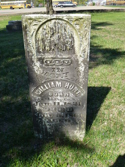

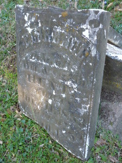
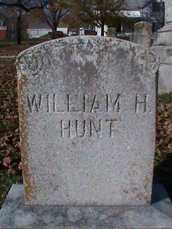
William Henry Hunt
| Birth | : | 11 Jan 1821 Shelbyville, Shelby County, Kentucky, USA |
| Death | : | 5 Jul 1861 St. Francois County, Missouri, USA |
| Burial | : | Jelle Cemetery, Jelle, Beltrami County, USA |
| Coordinate | : | 48.2380560, -95.4111110 |
frequently asked questions (FAQ):
-
Where is William Henry Hunt's memorial?
William Henry Hunt's memorial is located at: Jelle Cemetery, Jelle, Beltrami County, USA.
-
When did William Henry Hunt death?
William Henry Hunt death on 5 Jul 1861 in St. Francois County, Missouri, USA
-
Where are the coordinates of the William Henry Hunt's memorial?
Latitude: 48.2380560
Longitude: -95.4111110
Family Members:
Parent
Spouse
Children
Flowers:


Nearby Cemetories:
1. Jelle Cemetery
Jelle, Beltrami County, USA
Coordinate: 48.2380560, -95.4111110
2. Our Saviors Cemetery
Four Town, Beltrami County, USA
Coordinate: 48.2667350, -95.4327440
3. Sundberg Cemetery
Beltrami County, USA
Coordinate: 48.3107986, -95.3846970
4. Bethesda Luther Cemetery
Beltrami County, USA
Coordinate: 48.2813790, -95.5089570
5. Lone Oak Cemetery
Beltrami County, USA
Coordinate: 48.3241210, -95.3350130
6. Rosebud Cemetery
Beltrami County, USA
Coordinate: 48.2155991, -95.2438965
7. Valle Cemetery
Beltrami County, USA
Coordinate: 48.3171997, -95.5516968
8. Stratton Family Cemetery
Four Town, Beltrami County, USA
Coordinate: 48.3125420, -95.2589320
9. Saint Olaf Cemetery
Grygla, Marshall County, USA
Coordinate: 48.2966995, -95.5978012
10. Saint Clement Catholic Cemetery
Grygla, Marshall County, USA
Coordinate: 48.2965970, -95.5998710
11. Espelie Cemetery
Espelie Township, Marshall County, USA
Coordinate: 48.2407900, -95.6368600
12. Saint Petri Cemetery
Grygla, Marshall County, USA
Coordinate: 48.3145600, -95.6906370
13. Reiner Cemetery
Thief River Falls, Pennington County, USA
Coordinate: 48.1223110, -95.6592570
14. Rosendahl Cemetery
Pennington County, USA
Coordinate: 48.1368280, -95.6812890
15. Poplar Grove Cemetery
Espelie, Marshall County, USA
Coordinate: 48.2351570, -95.7219950
16. Jerusalem Cemetery
Espelie Township, Marshall County, USA
Coordinate: 48.2350006, -95.7225037
17. Star Cemetery
Pennington County, USA
Coordinate: 48.0853004, -95.6358032
18. Northwood Cemetery
Beltrami County, USA
Coordinate: 48.4408800, -95.5410100
19. Czech National Cemetery
Goodridge, Pennington County, USA
Coordinate: 48.0930330, -95.7113170
20. Little Oak Cemetery
Pennington County, USA
Coordinate: 48.0144005, -95.6166992
21. Goodridge Cemetery
Goodridge, Pennington County, USA
Coordinate: 48.1638985, -95.8097000
22. Ekelund Cemetery
Goodridge, Pennington County, USA
Coordinate: 48.0634040, -95.7339300
23. Landstad Cemetery
Marshall County, USA
Coordinate: 48.4105988, -95.7639008
24. Penturen Catholic Cemetery
Roseau, Roseau County, USA
Coordinate: 48.5507800, -95.3452200