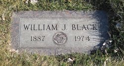
William Jefferson Black
| Birth | : | 26 Aug 1887 Horton, Brown County, Kansas, USA |
| Death | : | 23 Aug 1974 Great Falls, Cascade County, Montana, USA |
| Burial | : | Manor Church of the Brethren Cemetery, Tilghmanton, Washington County, USA |
| Coordinate | : | 39.5285988, -77.7264023 |
| Plot | : | Section 2 |
| Description | : | The Choteau Acantha (MT), 29 Aug 1974 William Black, Dutton Farmer, Dies on Friday William J. Black, 86, Dutton farmer, died in a Great Falls nursing home where he had resided the past year and a half. Funeral services were conducted in the Dutton United Methodist church with burial in Highland cemetery. Black, born in Horton, Kan., came to Montana in 1914 and homesteaded at Ballantine. He married Ella Young in Shelby in 1923. He worked in the oil fields in that area for 20 years and then moved to Dutton. He farmed in the Cut Bank-Shelby vicinity until... Read More |
frequently asked questions (FAQ):
-
Where is William Jefferson Black's memorial?
William Jefferson Black's memorial is located at: Manor Church of the Brethren Cemetery, Tilghmanton, Washington County, USA.
-
When did William Jefferson Black death?
William Jefferson Black death on 23 Aug 1974 in Great Falls, Cascade County, Montana, USA
-
Where are the coordinates of the William Jefferson Black's memorial?
Latitude: 39.5285988
Longitude: -77.7264023
Family Members:
Parent
Spouse
Siblings
Children
Flowers:
Nearby Cemetories:
1. Manor Church of the Brethren Cemetery
Tilghmanton, Washington County, USA
Coordinate: 39.5285988, -77.7264023
2. Emmert Graveyard
Tilghmanton, Washington County, USA
Coordinate: 39.5265850, -77.7306050
3. Saint Marks Episcopal Church Cemetery
Lappans, Washington County, USA
Coordinate: 39.5508003, -77.7341995
4. Salem Lutheran Church Cemetery
Bakersville, Washington County, USA
Coordinate: 39.5135680, -77.7559970
5. Benevola United Methodist Church Cemetery
Benevola, Washington County, USA
Coordinate: 39.5452000, -77.6745000
6. Fairview Cemetery
Keedysville, Washington County, USA
Coordinate: 39.4882200, -77.7023600
7. Mumma Cemetery
Sharpsburg, Washington County, USA
Coordinate: 39.4780000, -77.7421900
8. Fountain Rock Cemetery
Saint James, Washington County, USA
Coordinate: 39.5753990, -77.7587110
9. Mount Hebron Cemetery
Keedysville, Washington County, USA
Coordinate: 39.4824982, -77.6900024
10. Antietam National Battlefield
Sharpsburg, Washington County, USA
Coordinate: 39.4742126, -77.7445374
11. Old Salem Church Cemetery
Boonsboro, Washington County, USA
Coordinate: 39.5062590, -77.6543710
12. Trinity Reformed United Church of Christ Cemetery
Boonsboro, Washington County, USA
Coordinate: 39.5058300, -77.6542800
13. Abraham Lemaster Gravesite
Boonsboro, Washington County, USA
Coordinate: 39.5084763, -77.6521835
14. Mount Zion Mennonite Church Cemetery
Mapleville, Washington County, USA
Coordinate: 39.5525017, -77.6530991
15. Boonsboro Cemetery
Boonsboro, Washington County, USA
Coordinate: 39.5045100, -77.6524700
16. Red Hill Cemetery
Keedysville, Washington County, USA
Coordinate: 39.4700100, -77.6989400
17. Meadow View Mennonite Church Cemetery
Hagerstown, Washington County, USA
Coordinate: 39.5937500, -77.7472000
18. Mountain View Cemetery
Sharpsburg, Washington County, USA
Coordinate: 39.4604800, -77.7419500
19. Antietam National Cemetery
Sharpsburg, Washington County, USA
Coordinate: 39.4601400, -77.7417700
20. Mount Calvary Lutheran Cemetery
Sharpsburg, Washington County, USA
Coordinate: 39.4591751, -77.7432175
21. Sharpsburg Reformed Cemetery
Sharpsburg, Washington County, USA
Coordinate: 39.4595900, -77.7486700
22. First Methodist Cemetery
Sharpsburg, Washington County, USA
Coordinate: 39.4581500, -77.7521700
23. Johnson Cemetery
Shepherdstown, Jefferson County, USA
Coordinate: 39.4815800, -77.8002900
24. Tolsons Chapel Cemetery
Sharpsburg, Washington County, USA
Coordinate: 39.4561900, -77.7463700


