
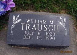
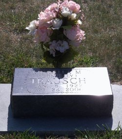
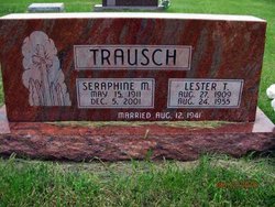
William M. “Bill” Trausch
| Birth | : | 6 Jul 1923 |
| Death | : | 12 Dec 1990 |
| Burial | : | Blue Springs Cemetery, Blue Springs, Jackson County, USA |
| Coordinate | : | 39.0158005, -94.2941971 |
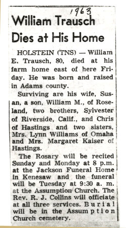
| Description | : | A farmer and a lifetime member of the Roseland community. Survived by five daughters, Marilyn Brundrett of Cedar Falls, IA, Patricia of Minden, Nancy Virella of Chicago, Denise Hitchcock of Roseland, Deborah of Denver; two sons Leonard of Roseland and Charles of Holstein; 13 grandchildren. |
frequently asked questions (FAQ):
-
Where is William M. “Bill” Trausch's memorial?
William M. “Bill” Trausch's memorial is located at: Blue Springs Cemetery, Blue Springs, Jackson County, USA.
-
When did William M. “Bill” Trausch death?
William M. “Bill” Trausch death on 12 Dec 1990 in
-
Where are the coordinates of the William M. “Bill” Trausch's memorial?
Latitude: 39.0158005
Longitude: -94.2941971
Family Members:
Parent
Spouse
Siblings
Children
Flowers:


Nearby Cemetories:
1. Blue Springs Cemetery
Blue Springs, Jackson County, USA
Coordinate: 39.0158005, -94.2941971
2. First United Methodist Church Columbarium
Blue Springs, Jackson County, USA
Coordinate: 39.0162500, -94.3021000
3. Stanley Cemetery
Blue Springs, Jackson County, USA
Coordinate: 39.0141983, -94.3208008
4. Louis Gore Family Cemetery
Blue Springs, Jackson County, USA
Coordinate: 38.9989000, -94.2636200
5. Bridges Cemetery
Blue Springs, Jackson County, USA
Coordinate: 38.9870200, -94.2826000
6. Johnson Family Cemetery
Lee's Summit, Jackson County, USA
Coordinate: 39.0048730, -94.3371080
7. Morgan Walker Cemetery
Blue Springs, Jackson County, USA
Coordinate: 39.0480003, -94.2730026
8. Cowherd Cemetery
Jackson County, USA
Coordinate: 38.9720001, -94.2979965
9. Gibson-Russell Cemetery
Independence, Jackson County, USA
Coordinate: 39.0674000, -94.3161800
10. Lobb Cemetery
Independence, Jackson County, USA
Coordinate: 39.0710983, -94.2889023
11. Perdee Chapel Cemetery
Grain Valley, Jackson County, USA
Coordinate: 38.9902992, -94.2307968
12. Woods Chapel Cemetery
Lee's Summit, Jackson County, USA
Coordinate: 38.9827385, -94.3537216
13. Valley Memorial Gardens
Grain Valley, Jackson County, USA
Coordinate: 39.0103989, -94.2158508
14. Howard Cemetery
Lee's Summit, Jackson County, USA
Coordinate: 38.9822600, -94.3648100
15. Swan Lake Memorial Gardens
Grain Valley, Jackson County, USA
Coordinate: 39.0578995, -94.2257996
16. McPherson Cemetery
Lee's Summit, Jackson County, USA
Coordinate: 38.9982700, -94.3811000
17. Slaughter Cemetery
Grain Valley, Jackson County, USA
Coordinate: 39.0613330, -94.2235350
18. Hylton Cemetery
Kansas City, Jackson County, USA
Coordinate: 39.0013100, -94.3887600
19. Luttrell Cemetery
Independence, Jackson County, USA
Coordinate: 39.0504700, -94.3839300
20. Saint Michael's Memorial Garden
Independence, Jackson County, USA
Coordinate: 39.0468200, -94.3877300
21. Grain Valley Cemetery
Grain Valley, Jackson County, USA
Coordinate: 39.0264015, -94.1877975
22. Noland Cemetery
Kansas City, Jackson County, USA
Coordinate: 39.0265700, -94.4005700
23. Oakland Cemetery
Buckner, Jackson County, USA
Coordinate: 39.0793991, -94.2202988
24. Jackson County Home Cemetery
Little Blue, Jackson County, USA
Coordinate: 38.9761990, -94.3946500