
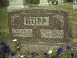
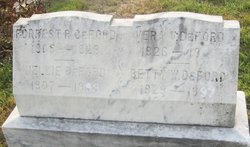
William Martin Hupp Sr.
| Birth | : | 22 Oct 1890 Licking County, Ohio, USA |
| Death | : | 26 Jul 1968 Licking County, Ohio, USA |
| Burial | : | Saint Marys Cemetery, Bronson, Branch County, USA |
| Coordinate | : | 41.8582993, -85.1939011 |
| Description | : | In 1900 he and his parents and four siblings lived on a farm they were renting in Madison Township in the same county. In 1910 he and his parents and six of his seven surviving siblings--all but Enyart, who was living with their paternal grandmother on her farm in Mary Ann Township--lived in a house they were renting in Hanover, OH. He and his father and brother Stanton all worked as section hands, laborers for a railroad. In 1920 he and his wife and their three children lived on a farm they owned, with a mortgage, in Perry... Read More |
frequently asked questions (FAQ):
-
Where is William Martin Hupp Sr.'s memorial?
William Martin Hupp Sr.'s memorial is located at: Saint Marys Cemetery, Bronson, Branch County, USA.
-
When did William Martin Hupp Sr. death?
William Martin Hupp Sr. death on 26 Jul 1968 in Licking County, Ohio, USA
-
Where are the coordinates of the William Martin Hupp Sr.'s memorial?
Latitude: 41.8582993
Longitude: -85.1939011
Family Members:
Parent
Spouse

Siblings
Children


Flowers:


Nearby Cemetories:
1. Saint Marys Cemetery
Bronson, Branch County, USA
Coordinate: 41.8582993, -85.1939011
2. Bronson Cemetery
Bronson, Branch County, USA
Coordinate: 41.8699340, -85.1858320
3. Snow Prairie Cemetery
Bethel, Branch County, USA
Coordinate: 41.8699989, -85.1408005
4. Curtis Cemetery
Bronson, Branch County, USA
Coordinate: 41.8039017, -85.1956024
5. North Gilead Cemetery
Gilead Township, Branch County, USA
Coordinate: 41.8039017, -85.1557999
6. York Cemetery
Batavia, Branch County, USA
Coordinate: 41.9009350, -85.1318550
7. Pleasant Hill Cemetery
Noble Township, Branch County, USA
Coordinate: 41.7961110, -85.2111110
8. Adams Cemetery
Bronson, Branch County, USA
Coordinate: 41.8405991, -85.2767029
9. Dutch Settlement Cemetery
Bronson, Branch County, USA
Coordinate: 41.8106003, -85.2632980
10. Matteson Cemetery
Matteson, Branch County, USA
Coordinate: 41.9406013, -85.2046967
11. South Gilead Cemetery
Bronson, Branch County, USA
Coordinate: 41.7733330, -85.1566670
12. Card Cemetery
Bethel Township, Branch County, USA
Coordinate: 41.8544006, -85.0693970
13. Batavia Cemetery
Batavia, Branch County, USA
Coordinate: 41.9202778, -85.0975000
14. Sanborn Cemetery
Burr Oak, St. Joseph County, USA
Coordinate: 41.8708000, -85.3305969
15. Burr Oak Township Cemetery
Burr Oak, St. Joseph County, USA
Coordinate: 41.8472214, -85.3319473
16. Trayer Cemetery
Bronson, Branch County, USA
Coordinate: 41.7705550, -85.2677770
17. South Colon Cemetery
Colon, St. Joseph County, USA
Coordinate: 41.9199982, -85.3114014
18. Ovid Cemetery
Ovid Township, Branch County, USA
Coordinate: 41.8688580, -85.0484920
19. East Gilead Cemetery
East Gilead, Branch County, USA
Coordinate: 41.7858330, -85.0825000
20. Eroh Cemetery
Fawn River Township, St. Joseph County, USA
Coordinate: 41.8081017, -85.3375015
21. Freedom Cemetery
Fawn River, St. Joseph County, USA
Coordinate: 41.8064003, -85.3371964
22. Tripp Cemetery
Batavia, Branch County, USA
Coordinate: 41.9425000, -85.0694440
23. Bartholomew Cemetery
Fawn River Township, St. Joseph County, USA
Coordinate: 41.8059600, -85.3476300
24. Mill Grove Cemetery
Orland, Steuben County, USA
Coordinate: 41.7327995, -85.1718979