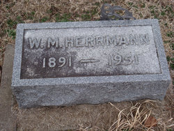
William Mitchell Herrmann
| Birth | : | 29 Nov 1891 Waterville, Marshall County, Kansas, USA |
| Death | : | 30 Oct 1951 Kansas, USA |
| Burial | : | Woods Chapel Cemetery, Greene County, USA |
| Coordinate | : | 35.9846992, -90.5678024 |
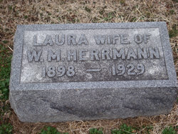
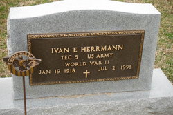
| Description | : | Son of Louis Franklin & Ann Martha (Baker) Herrmann. Married Apr. 11, 1917 to Laura Christine Ricard. Remarried Nov. 30, 1930 to Emma Nemechek. Farmer. Father of Ivan Eugene. |
frequently asked questions (FAQ):
-
Where is William Mitchell Herrmann's memorial?
William Mitchell Herrmann's memorial is located at: Woods Chapel Cemetery, Greene County, USA.
-
When did William Mitchell Herrmann death?
William Mitchell Herrmann death on 30 Oct 1951 in Kansas, USA
-
Where are the coordinates of the William Mitchell Herrmann's memorial?
Latitude: 35.9846992
Longitude: -90.5678024
Family Members:
Spouse
Children
Flowers:
Nearby Cemetories:
1. Woods Chapel Cemetery
Greene County, USA
Coordinate: 35.9846992, -90.5678024
2. Sims Cemetery
Craighead County, USA
Coordinate: 35.9639015, -90.5550003
3. Sweet Moments Cemetery
Craighead County, USA
Coordinate: 35.9631004, -90.5849991
4. Bethel Cemetery
Greene County, USA
Coordinate: 36.0022011, -90.5361023
5. Browns Chapel Cemetery
Paragould, Greene County, USA
Coordinate: 36.0168991, -90.5500031
6. Liberty Cemetery
Greene County, USA
Coordinate: 35.9992350, -90.6110070
7. Clarks Chapel Cemetery
Paragould, Greene County, USA
Coordinate: 35.9804020, -90.6189040
8. Pine Knot Cemetery
Paragould, Greene County, USA
Coordinate: 36.0283012, -90.5988998
9. Finch Cemetery
Finch, Greene County, USA
Coordinate: 36.0102997, -90.6241989
10. Pruett's Chapel Cemetery
Paragould, Greene County, USA
Coordinate: 36.0332985, -90.5278015
11. Pine Log Cemetery
Brookland, Craighead County, USA
Coordinate: 35.9314003, -90.6053009
12. Rutherford Cemetery
Craighead County, USA
Coordinate: 35.9578018, -90.6444016
13. Saint Marys Cemetery
Paragould, Greene County, USA
Coordinate: 36.0449982, -90.5093994
14. Old Bethel Cemetery
Paragould, Greene County, USA
Coordinate: 36.0126220, -90.6587790
15. Center Hill Cemetery
Paragould, Greene County, USA
Coordinate: 36.0602989, -90.5393982
16. Shiloh Cemetery
Paragould, Greene County, USA
Coordinate: 36.0667000, -90.5622025
17. Brookland Methodist Cemetery
Brookland, Craighead County, USA
Coordinate: 35.9015160, -90.5847330
18. Linwood Cemetery
Paragould, Greene County, USA
Coordinate: 36.0508003, -90.5025024
19. Nober Cemetery
Brookland, Craighead County, USA
Coordinate: 35.8932991, -90.6038971
20. Noble Cemetery
Craighead County, USA
Coordinate: 35.8931240, -90.6043840
21. Rock Hill Cemetery
Jonesboro, Craighead County, USA
Coordinate: 35.9441986, -90.6757965
22. Fairview Cemetery
Paragould, Greene County, USA
Coordinate: 36.0842018, -90.5653000
23. Lansing-Cox Cemetery
Greene County, USA
Coordinate: 35.9794600, -90.4447900
24. Mount Zion Cemetery
Walcott, Greene County, USA
Coordinate: 36.0231018, -90.6828003


