

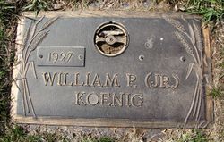

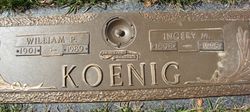
William Paul “Bill” Koenig Jr.
| Birth | : | 19 Jul 1927 Blair, Washington County, Nebraska, USA |
| Death | : | 13 Mar 2019 Storm Lake, Buena Vista County, Iowa, USA |
| Burial | : | North Lawn Cemetery, Spencer, Clay County, USA |
| Coordinate | : | 43.1600000, -95.1470000 |
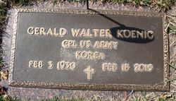
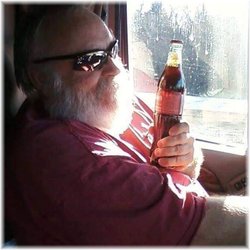
| Description | : | William “Bill” Paul Koenig, Jr. was born on July 19, 1927 to Ingrey and William Koenig Sr., in Blair, NE, where he spent his childhood with two brothers, George and Gerald. The family then moved to a farm in rural Ayrshire in 1943. He attended school and graduated in 1945 as a Gillett Grove Hilltopper. Bill married Joan Martha O’Hearn on February 20, 1949. They purchased an acreage in Gillett Grove where they lived and farmed and raised six children: Steven Eugene, Deborah Ann, Martin Paul, Cynthia Ann, Randall Lee and Jeffrey Allan. |
frequently asked questions (FAQ):
-
Where is William Paul “Bill” Koenig Jr.'s memorial?
William Paul “Bill” Koenig Jr.'s memorial is located at: North Lawn Cemetery, Spencer, Clay County, USA.
-
When did William Paul “Bill” Koenig Jr. death?
William Paul “Bill” Koenig Jr. death on 13 Mar 2019 in Storm Lake, Buena Vista County, Iowa, USA
-
Where are the coordinates of the William Paul “Bill” Koenig Jr.'s memorial?
Latitude: 43.1600000
Longitude: -95.1470000
Family Members:
Parent

Spouse
Siblings
Children
Flowers:


Nearby Cemetories:
1. North Lawn Cemetery
Spencer, Clay County, USA
Coordinate: 43.1600000, -95.1470000
2. Dewey Readmore Books Memorial
Spencer, Clay County, USA
Coordinate: 43.1403999, -95.1443024
3. Riverside Cemetery
Spencer, Clay County, USA
Coordinate: 43.1441994, -95.1671982
4. Fairview Cemetery
Clay County, USA
Coordinate: 43.1899986, -95.0800018
5. Evergreen Cemetery
Clay County, USA
Coordinate: 43.2052994, -95.2086029
6. Dickens Cemetery
Dickens, Clay County, USA
Coordinate: 43.1280000, -95.0155000
7. Swedish Lutheran Cemetery
Royal, Clay County, USA
Coordinate: 43.0683000, -95.2350000
8. Little Sioux Lutheran Cemetery
Milford, Dickinson County, USA
Coordinate: 43.2702065, -95.2109528
9. Rosehill Cemetery
Clay County, USA
Coordinate: 43.0368996, -95.0919037
10. First Reformed Cemetery
Clay County, USA
Coordinate: 43.2399500, -95.2889000
11. Lone Tree Cemetery
Everly, Clay County, USA
Coordinate: 43.1411018, -95.3347015
12. Milford Cemetery
Milford, Dickinson County, USA
Coordinate: 43.3092003, -95.1481018
13. Lincoln Cemetery
Rossie, Clay County, USA
Coordinate: 43.0111008, -95.2313995
14. Calvary Cemetery
Milford, Dickinson County, USA
Coordinate: 43.3213997, -95.1688995
15. Logan Township Cemetery
Clay County, USA
Coordinate: 43.0489006, -94.9747009
16. Liberty Cemetery
Greenville, Clay County, USA
Coordinate: 42.9897003, -95.1417007
17. Willow Creek Cemetery
Royal, Clay County, USA
Coordinate: 43.0214005, -95.2885971
18. Clay Center Cemetery
Royal, Clay County, USA
Coordinate: 43.0410995, -95.3272018
19. TriMello Cemetery
Royal, Clay County, USA
Coordinate: 43.0682983, -95.3728027
20. Crown Hill Cemetery
Ruthven, Palo Alto County, USA
Coordinate: 43.1328011, -94.8878021
21. Calvary Cemetery
Ruthven, Palo Alto County, USA
Coordinate: 43.1314011, -94.8869019
22. Zion Methodist Cemetery
Clay County, USA
Coordinate: 42.9808006, -95.2497025
23. Westport Cemetery
Dickinson County, USA
Coordinate: 43.3130989, -95.3289032
24. Okoboji Cemetery
Arnolds Park, Dickinson County, USA
Coordinate: 43.3649406, -95.1303558