

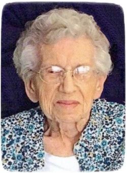
Joan O'Hearn Koenig
| Birth | : | 13 Jan 1931 Spencer, Clay County, Iowa, USA |
| Death | : | 22 Apr 2016 Gillett Grove, Clay County, Iowa, USA |
| Burial | : | Rosehill Cemetery, Clay County, USA |
| Coordinate | : | 43.0368996, -95.0919037 |
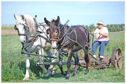
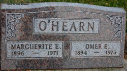
| Description | : | Joan O’Hearn was born January 13, 1931 in Spencer, Iowa, to Omer and Marguerite (Parks) O’Hearn. On February 20, 1949 Joan was united in marriage to William “Bill” Koenig in Spencer. Together they did farming and custom shelling. There she developed her ability to cook and provide food for large crowds. Together they were blessed with six children: Steve, Deb, Marty, Cindy, Randy, and Jeff. Joan had a strong love for horses and mules. Joan was a proud supporter of the Shayla Bee Foundation, Reins of Hope, and Pony Express Riders of Iowa fundraisers. She was also... Read More |
frequently asked questions (FAQ):
-
Where is Joan O'Hearn Koenig's memorial?
Joan O'Hearn Koenig's memorial is located at: Rosehill Cemetery, Clay County, USA.
-
When did Joan O'Hearn Koenig death?
Joan O'Hearn Koenig death on 22 Apr 2016 in Gillett Grove, Clay County, Iowa, USA
-
Where are the coordinates of the Joan O'Hearn Koenig's memorial?
Latitude: 43.0368996
Longitude: -95.0919037
Family Members:
Parent

Spouse

Siblings

Children

Flowers:


Nearby Cemetories:
1. Rosehill Cemetery
Clay County, USA
Coordinate: 43.0368996, -95.0919037
2. Liberty Cemetery
Greenville, Clay County, USA
Coordinate: 42.9897003, -95.1417007
3. Logan Township Cemetery
Clay County, USA
Coordinate: 43.0489006, -94.9747009
4. Fanny Fern Cemetery
Clay County, USA
Coordinate: 42.9530983, -95.1607971
5. Osborn Cemetery
Webb, Clay County, USA
Coordinate: 42.9346918, -95.0608244
6. Lincoln Cemetery
Rossie, Clay County, USA
Coordinate: 43.0111008, -95.2313995
7. Dickens Cemetery
Dickens, Clay County, USA
Coordinate: 43.1280000, -95.0155000
8. Swedish Lutheran Cemetery
Royal, Clay County, USA
Coordinate: 43.0683000, -95.2350000
9. Dewey Readmore Books Memorial
Spencer, Clay County, USA
Coordinate: 43.1403999, -95.1443024
10. Burr Oak Cemetery
Herdland Township, Clay County, USA
Coordinate: 42.9235992, -95.0907974
11. Riverside Cemetery
Spencer, Clay County, USA
Coordinate: 43.1441994, -95.1671982
12. Zion Methodist Cemetery
Clay County, USA
Coordinate: 42.9808006, -95.2497025
13. North Lawn Cemetery
Spencer, Clay County, USA
Coordinate: 43.1600000, -95.1470000
14. Garfield Township Cemetery
Webb, Clay County, USA
Coordinate: 42.9538994, -94.9392014
15. Willow Creek Cemetery
Royal, Clay County, USA
Coordinate: 43.0214005, -95.2885971
16. Saint Josephs Cemetery
Sioux Rapids, Buena Vista County, USA
Coordinate: 42.8883018, -95.1324997
17. Fairview Cemetery
Clay County, USA
Coordinate: 43.1899986, -95.0800018
18. Douglas Township Cemetery
Clay County, USA
Coordinate: 42.9255981, -95.2450027
19. Lone Tree Cemetery
Sioux Rapids, Buena Vista County, USA
Coordinate: 42.8819008, -95.1492004
20. Calvary Cemetery
Silver Lake Township, Palo Alto County, USA
Coordinate: 43.0386009, -94.8613968
21. Silver Lake Cemetery
Silver Lake Township, Palo Alto County, USA
Coordinate: 43.0386009, -94.8597031
22. Clay Center Cemetery
Royal, Clay County, USA
Coordinate: 43.0410995, -95.3272018
23. Calvary Cemetery
Ruthven, Palo Alto County, USA
Coordinate: 43.1314011, -94.8869019
24. Crown Hill Cemetery
Ruthven, Palo Alto County, USA
Coordinate: 43.1328011, -94.8878021