
| Birth | : | 16 Sep 1929 Cherryvale, Montgomery County, Kansas, USA |
| Death | : | 1 Dec 2015 Hutchinson, Reno County, Kansas, USA |
| Burial | : | Burrton Cemetery, Burrton, Harvey County, USA |
| Coordinate | : | 38.0150757, -97.6750793 |
| Plot | : | Block 3 lot 123 space 4 |
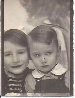
| Description | : | William R. “Bill” Cornett, 86, died December 1, 2015, at Hospice House, Hutchinson. He was born September 16, 1929, in Cherryvale, to John “J.A.” and Gladys (Truster) Cornett. Bill graduated from Burrton High School in 1949. He was drafted into the U.S. Army in 1952 and served as a corporal. After the Army, he worked as an oilfield production supervisor. Bill enjoyed gardening and fishing and was a former member of Masonic Lodge and Consistory. He attended Burrton United Methodist Church. On July 30, 1949, he married Charlene Collins in Burrton. They celebrated 66 years of marriage. Bill is survived... Read More |
frequently asked questions (FAQ):
-
Where is William Rolland “Bill” Cornett's memorial?
William Rolland “Bill” Cornett's memorial is located at: Burrton Cemetery, Burrton, Harvey County, USA.
-
When did William Rolland “Bill” Cornett death?
William Rolland “Bill” Cornett death on 1 Dec 2015 in Hutchinson, Reno County, Kansas, USA
-
Where are the coordinates of the William Rolland “Bill” Cornett's memorial?
Latitude: 38.0150757
Longitude: -97.6750793
Family Members:

Flowers:


Nearby Cemetories:
1. Burrton Cemetery
Burrton, Harvey County, USA
Coordinate: 38.0150757, -97.6750793
2. Hunt Cemetery
Patterson, Harvey County, USA
Coordinate: 37.9413000, -97.6657000
3. Valley Township Cemetery
Haven, Reno County, USA
Coordinate: 37.9491550, -97.7474530
4. Star Cemetery
Patterson, Harvey County, USA
Coordinate: 37.9263687, -97.6833878
5. Old Halstead Cemetery
Harvey County, USA
Coordinate: 38.0067350, -97.5297160
6. Little River Township Cemetery
Buhler, Reno County, USA
Coordinate: 38.1369019, -97.7205963
7. Hebron Cemetery
Burrton, Harvey County, USA
Coordinate: 38.1432991, -97.6883011
8. Fairview Cemetery
Harvey County, USA
Coordinate: 38.0574100, -97.5186100
9. Buhler East Cemetery
Reno County, USA
Coordinate: 38.1453018, -97.7071991
10. Halstead Cemetery Mausoleum
Halstead, Harvey County, USA
Coordinate: 38.0287000, -97.5002400
11. Martens Family Cemetery
Buhler, Reno County, USA
Coordinate: 38.1472400, -97.7292700
12. Halstead Cemetery
Halstead, Harvey County, USA
Coordinate: 38.0264015, -97.4989014
13. Garden View Mennonite Church Cemetery
Hesston, Harvey County, USA
Coordinate: 38.0874400, -97.5128900
14. Yoder Amish Cemetery
Yoder, Reno County, USA
Coordinate: 37.9412330, -97.8389500
15. Thiessen Family Cemetery
Buhler, Reno County, USA
Coordinate: 38.1411000, -97.7764000
16. Irons Farm Cemetery
Bentley, Sedgwick County, USA
Coordinate: 37.9072300, -97.5433100
17. Saint Pauls Lutheran Church Cemetery
Haven, Reno County, USA
Coordinate: 37.8974410, -97.7939490
18. Buhler Municipal Cemetery
Buhler, Reno County, USA
Coordinate: 38.1445000, -97.7750000
19. Lohrentz Cemetery
Harvey County, USA
Coordinate: 38.1518374, -97.5843430
20. Schroeder Family Cemetery
Buhler, Reno County, USA
Coordinate: 38.1664700, -97.7211600
21. Laurel Cemetery
Haven, Reno County, USA
Coordinate: 37.9268990, -97.8394012
22. Haven Priest Cemetery
Haven, Reno County, USA
Coordinate: 37.8685989, -97.7457962
23. Mount Hope Cemetery
Mount Hope, Sedgwick County, USA
Coordinate: 37.8546982, -97.6744003
24. Yoder Mennonite Church Cemetery
Yoder, Reno County, USA
Coordinate: 37.9546300, -97.8662800