
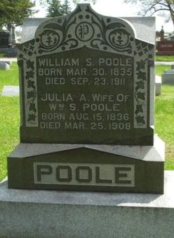
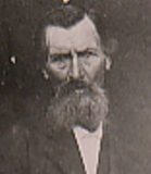

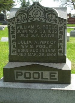
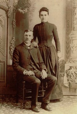
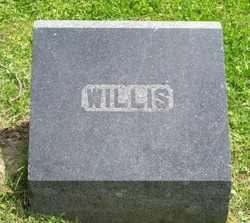
William Sylvester Poole
| Birth | : | 30 Mar 1835 Leesville, Lawrence County, Indiana, USA |
| Death | : | 23 Sep 1911 Muscatine County, Iowa, USA |
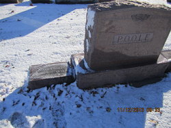
| Burial | : | Forest Grove Cemetery, Tenino, Thurston County, USA |
| Coordinate | : | 46.8254580, -122.8497110 |
| Plot | : | Sec B/Lot 5/Sp 2 |
| Description | : | History of Muscatine County Iowa, Volume II, Biographical, 1911, page 245 WILLIAM S. POOLE. William S. Poole, a retired agriculturist of Wapsinonoc township, is the owner of a farm which has been in his possession and on which he has resided continuously for the past forty-seven years. The property embraces one hundred and sixty-three acres of land on section 17 and is well improved in every particular. His birth occurred in Indiana on the 30th of March, 1835, his parents being Macajah and Rebecca ( Ralson ) Poole, who were natives of Virginia and Ohio respectively. They took up their abode... Read More |
frequently asked questions (FAQ):
-
Where is William Sylvester Poole's memorial?
William Sylvester Poole's memorial is located at: Forest Grove Cemetery, Tenino, Thurston County, USA.
-
When did William Sylvester Poole death?
William Sylvester Poole death on 23 Sep 1911 in Muscatine County, Iowa, USA
-
Where are the coordinates of the William Sylvester Poole's memorial?
Latitude: 46.8254580
Longitude: -122.8497110
Family Members:
Parent
Spouse
Siblings

Children
Flowers:


Nearby Cemetories:
1. Forest Grove Cemetery
Tenino, Thurston County, USA
Coordinate: 46.8254580, -122.8497110
2. Cogdil Family Cemetery
Thurston County, USA
Coordinate: 46.7747010, -122.8826590
3. Grand Mound Cemetery
Rochester, Thurston County, USA
Coordinate: 46.8213997, -123.0199966
4. Greenwood Memorial Park
Centralia, Lewis County, USA
Coordinate: 46.7372017, -122.9824982
5. Washington Lawn Cemetery
Centralia, Lewis County, USA
Coordinate: 46.7209320, -122.9606040
6. Thurston County Poor Farm Cemetery
Littlerock, Thurston County, USA
Coordinate: 46.8861790, -123.0225100
7. Mountain View Cemetery
Centralia, Lewis County, USA
Coordinate: 46.7289009, -122.9843979
8. Pioneer Cemetery
Centralia, Lewis County, USA
Coordinate: 46.7290300, -122.9898100
9. Rainier Cemetery
Rainier, Thurston County, USA
Coordinate: 46.8983500, -122.6771300
10. Mima Prairie Pioneer Cemetery
Mima, Thurston County, USA
Coordinate: 46.8724403, -123.0611649
11. Deskins Family Cemetery
Chehalis, Lewis County, USA
Coordinate: 46.6878000, -122.7530000
12. Union Cemetery
Tumwater, Thurston County, USA
Coordinate: 46.9954410, -122.9215700
13. Pioneer Calvary Catholic Cemetery
Tumwater, Thurston County, USA
Coordinate: 46.9951280, -122.9233700
14. Mills and Mills Memorial Park
Tumwater, Thurston County, USA
Coordinate: 46.9956800, -122.9214230
15. Greenwood Cemetery
Chehalis, Lewis County, USA
Coordinate: 46.6511002, -122.9389038
16. Woodlawn Cemetery
Lacey, Thurston County, USA
Coordinate: 47.0088692, -122.8046875
17. Ruddell Pioneer Cemetery
Lacey, Thurston County, USA
Coordinate: 47.0093613, -122.8083572
18. Laramie Family Cemetery
Thurston County, USA
Coordinate: 46.8376202, -122.5778103
19. Calvary Catholic Cemetery
Tumwater, Thurston County, USA
Coordinate: 47.0126250, -122.8925620
20. Delphi Pioneer Cemetery
Olympia, Thurston County, USA
Coordinate: 46.9675827, -123.0344009
21. Odd Fellows Memorial Park and Mausoleum
Tumwater, Thurston County, USA
Coordinate: 47.0138397, -122.8980865
22. Temple Beth Hatfiloh Cemetery
Tumwater, Thurston County, USA
Coordinate: 47.0143738, -122.8958206
23. Masonic Memorial Park
Tumwater, Thurston County, USA
Coordinate: 47.0160141, -122.8963242
24. Schmidt Family Cemetery
Tumwater, Thurston County, USA
Coordinate: 47.0183601, -122.9023209