
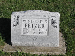
Winifred Elaine Schwada Fetzer
| Birth | : | 6 Dec 1923 Clarence, Shelby County, Missouri, USA |
| Death | : | 8 Dec 1994 Chesterfield, St. Louis County, Missouri, USA |
| Burial | : | Maplewood Cemetery, Clarence, Shelby County, USA |
| Coordinate | : | 39.7508011, -92.2572021 |
| Plot | : | BUNN Block 6 Row 1 Lot 34s |
| Description | : | The oldest daughter of James "Monloe" Schwada and Myrtle Lillian Prange, Winifred was born north of Clarence, Shelby County, Missouri. She was a 1941 graduated of Clarence High School, and she then attended Chillicothe Business College in Chillicothe, Missouri. Winifred lived in Washing, D. C. She worked for the United States Department of Agriculture for many years. Winifred married Lieutenant Colonel Carl Dawson Fetzer on 11 May 1973 in Arlington County, Virginia. He was the son of Wallace W. Fetzer and Elizabeth Emma "Lizzie" Dawson, and he was a World War II veteran. Carl passed away 4 years after their marriage and... Read More |
frequently asked questions (FAQ):
-
Where is Winifred Elaine Schwada Fetzer's memorial?
Winifred Elaine Schwada Fetzer's memorial is located at: Maplewood Cemetery, Clarence, Shelby County, USA.
-
When did Winifred Elaine Schwada Fetzer death?
Winifred Elaine Schwada Fetzer death on 8 Dec 1994 in Chesterfield, St. Louis County, Missouri, USA
-
Where are the coordinates of the Winifred Elaine Schwada Fetzer's memorial?
Latitude: 39.7508011
Longitude: -92.2572021
Family Members:
Parent
Spouse
Siblings

Flowers:


Nearby Cemetories:
1. Maplewood Cemetery
Clarence, Shelby County, USA
Coordinate: 39.7508011, -92.2572021
2. Clarence City Cemetery
Clarence, Shelby County, USA
Coordinate: 39.7493750, -92.2624800
3. Saint Patricks Cemetery
Clarence, Shelby County, USA
Coordinate: 39.7352982, -92.2714005
4. Hopper Cemetery
Shelby County, USA
Coordinate: 39.8083000, -92.2683029
5. Amish Cemetery
Macon County, USA
Coordinate: 39.7858009, -92.3208008
6. Hawkins Cemetery
Shelby County, USA
Coordinate: 39.8111000, -92.2874985
7. Bethel Christian Church Cemetery
Anabel, Macon County, USA
Coordinate: 39.8018200, -92.3252200
8. Patton Cemetery
Hagers Grove, Shelby County, USA
Coordinate: 39.8155700, -92.2022800
9. Ebenezer Cemetery
Hagers Grove, Shelby County, USA
Coordinate: 39.8302994, -92.2652969
10. Walker Cemetery
Macon County, USA
Coordinate: 39.6823640, -92.3117360
11. Winn Family Cemetery
Macon County, USA
Coordinate: 39.7589684, -92.3646774
12. Hagers Grove Cemetery
Hagers Grove, Shelby County, USA
Coordinate: 39.8305000, -92.2236000
13. Ewing Cemetery
Macon County, USA
Coordinate: 39.7616997, -92.3688965
14. Union Grove Cemetery
Clarence, Shelby County, USA
Coordinate: 39.6630360, -92.2602920
15. Ten Mile Baptist Church Cemetery
Ten Mile, Macon County, USA
Coordinate: 39.8082120, -92.3440980
16. Bethlehem Cemetery
Macon, Macon County, USA
Coordinate: 39.7070007, -92.3570023
17. Brown Cemetery
Macon County, USA
Coordinate: 39.7499140, -92.3723280
18. Sage Cemetery
Macon County, USA
Coordinate: 39.6738570, -92.3175640
19. Graves Chapel Cemetery
Anabel, Macon County, USA
Coordinate: 39.6815900, -92.3337200
20. Bacon Chapel Cemetery
Shelbyville, Shelby County, USA
Coordinate: 39.7511487, -92.1368436
21. Morris Cemetery
Shelby County, USA
Coordinate: 39.8227997, -92.1808014
22. Mount Hope Cemetery
Shelby County, USA
Coordinate: 39.7930984, -92.1442032
23. Harris Graveyard
Woodville, Macon County, USA
Coordinate: 39.6863850, -92.3543810
24. Mitts Cemetery
Macon County, USA
Coordinate: 39.8466988, -92.2913971