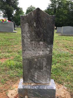
Zachariah “Zack” Payne
| Birth | : | 26 May 1845 Carroll County, Virginia, USA |
| Death | : | 28 May 1929 |
| Burial | : | Geraldine Cemetery, Geraldine, Timaru District, New Zealand |
| Coordinate | : | -44.0982600, 171.2407000 |
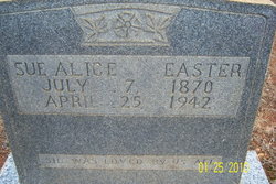
| Description | : | Was married first to Malinda (Linda) Carlan. They divorced 8-1-1866 (Hillsville Book 2, p 195, file #110) Then he married his first cousin Charlotte Payne and they had 4 children: Saulice Payne b. 7-7-1870; Stephen b. 1875; Ambrose Payne b. 1880 and Sanders Payne bor 9-19-1883. After Charlotte died he re-married Malinda (Linda) Carlan. According to Scott Hutchison (mem.#46635174) and a member of findagrave, Zacharia was soldier in the Confederate Southern Army but he was unable to make out the Unit from poor copy of pension. |
frequently asked questions (FAQ):
-
Where is Zachariah “Zack” Payne's memorial?
Zachariah “Zack” Payne's memorial is located at: Geraldine Cemetery, Geraldine, Timaru District, New Zealand.
-
When did Zachariah “Zack” Payne death?
Zachariah “Zack” Payne death on 28 May 1929 in
-
Where are the coordinates of the Zachariah “Zack” Payne's memorial?
Latitude: -44.0982600
Longitude: 171.2407000
Family Members:
Spouse
Children
Flowers:
Nearby Cemetories:
1. Geraldine Cemetery
Geraldine, Timaru District, New Zealand
Coordinate: -44.0982600, 171.2407000
2. St. Anne's Churchyard
Geraldine, Timaru District, New Zealand
Coordinate: -44.0836111, 171.1994444
3. Woodbury Cemetery
Woodbury, Timaru District, New Zealand
Coordinate: -44.0360900, 171.2127000
4. Saint Aidan's Churchyard
Geraldine, Timaru District, New Zealand
Coordinate: -44.1544420, 171.0980340
5. Arundel Cemetery
Arundel, Timaru District, New Zealand
Coordinate: -43.9785690, 171.2838900
6. Temuka Cemetery
Temuka, Timaru District, New Zealand
Coordinate: -44.2499010, 171.3014390
7. Whareki Cemetery
Temuka, Timaru District, New Zealand
Coordinate: -44.2558600, 171.2734500
8. Cracroft Cemetery
Ruapuna, Ashburton District, New Zealand
Coordinate: -43.9341900, 171.2989500
9. Pleasant Point Cemetery
Pleasant Point, Timaru District, New Zealand
Coordinate: -44.2615490, 171.1237320
10. St David’s Anglican Churchyard
Mackenzie District, New Zealand
Coordinate: -44.1706380, 170.9887810
11. Hinds Cemetery
Hinds, Ashburton District, New Zealand
Coordinate: -44.0075580, 171.5735400
12. Church of the Holy Innocents Churchyard
Peel Forest, Timaru District, New Zealand
Coordinate: -43.8398520, 171.2471820
13. Ruapuna Cemetery
Ruapuna, Ashburton District, New Zealand
Coordinate: -43.8436110, 171.3680400
14. Fairlie Cemetery
Fairlie, Mackenzie District, New Zealand
Coordinate: -44.1075700, 170.8301500
15. Windermere Cemetery
Windermere, Ashburton District, New Zealand
Coordinate: -43.9874945, 171.6232358
16. Albury Cemetery
Albury, Mackenzie District, New Zealand
Coordinate: -44.2371220, 170.8736570
17. Burnett Family Cemetery
Cave, Timaru District, New Zealand
Coordinate: -44.3156830, 170.9457270
18. Timaru Cemetery
Timaru, Timaru District, New Zealand
Coordinate: -44.4122320, 171.2574270
19. Longbeach Estate Chapel
Longbeach, Ashburton District, New Zealand
Coordinate: -44.0941090, 171.6884504
20. Winslow Cemetery
Winslow, Ashburton District, New Zealand
Coordinate: -43.9576290, 171.6522810
21. Salisbury Park Crematorium
Timaru, Timaru District, New Zealand
Coordinate: -44.4292400, 171.2080200
22. Pareora West Cemetery
Pareora West, Timaru District, New Zealand
Coordinate: -44.4383120, 171.1343000
23. Waterton Cemetery
Eiffelton, Ashburton District, New Zealand
Coordinate: -44.0640000, 171.7260000
24. Upper Rangitata Cemetery
Rangitata, Timaru District, New Zealand
Coordinate: -43.7575112, 171.0907394


