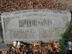
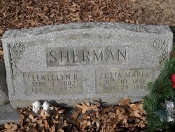
Zulia Mabel Strader Sherman
| Birth | : | 10 Oct 1898 Nevada, Vernon County, Missouri, USA |
| Death | : | 25 Mar 1961 Kansas City, Jackson County, Missouri, USA |
| Burial | : | Union Cemetery, Brentwood, Contra Costa County, USA |
| Coordinate | : | 37.9103012, -121.6477966 |
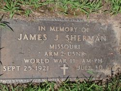
| Description | : | Daughter of George William and Minnie Belle Sutton-Strader. Married May 2, 1915 to Llewellyn Reece Sherman at Arapahoe County, Colorado. Nine children born to this union. Gold Star Mother of WWII. |
frequently asked questions (FAQ):
-
Where is Zulia Mabel Strader Sherman's memorial?
Zulia Mabel Strader Sherman's memorial is located at: Union Cemetery, Brentwood, Contra Costa County, USA.
-
When did Zulia Mabel Strader Sherman death?
Zulia Mabel Strader Sherman death on 25 Mar 1961 in Kansas City, Jackson County, Missouri, USA
-
Where are the coordinates of the Zulia Mabel Strader Sherman's memorial?
Latitude: 37.9103012
Longitude: -121.6477966
Family Members:
Parent
Spouse
Siblings
Children
Nearby Cemetories:
1. Union Cemetery
Brentwood, Contra Costa County, USA
Coordinate: 37.9103012, -121.6477966
2. Haney Family Estate Cemetery
Antioch, Contra Costa County, USA
Coordinate: 38.0027700, -121.7704400
3. Oak View Memorial Park
Antioch, Contra Costa County, USA
Coordinate: 38.0036011, -121.7696991
4. Holy Cross Cemetery
Antioch, Contra Costa County, USA
Coordinate: 38.0057983, -121.7733002
5. Rose Hill Cemetery
Antioch, Contra Costa County, USA
Coordinate: 37.9576700, -121.8713100
6. Five Pillars Farm Cemetery
Livermore, Alameda County, USA
Coordinate: 37.7262764, -121.7105789
7. Collinsville Cemetery
Collinsville, Solano County, USA
Coordinate: 38.0768635, -121.8499580
8. Roselawn Cemetery
Livermore, Alameda County, USA
Coordinate: 37.6947000, -121.7734800
9. Saint Michaels Cemetery
Livermore, Alameda County, USA
Coordinate: 37.6797790, -121.7519150
10. IOOF Memory Gardens Cemetery
Livermore, Alameda County, USA
Coordinate: 37.6797850, -121.7526100
11. Valpico Memorial Park
Tracy, San Joaquin County, USA
Coordinate: 37.7113260, -121.4656510
12. Rio Vista Memorial Park
Rio Vista, Solano County, USA
Coordinate: 38.1603127, -121.6971054
13. Rio Vista Catholic Cemetery
Rio Vista, Solano County, USA
Coordinate: 38.1611176, -121.6976471
14. Rio Vista Odd Fellows and Masonic Cemetery
Rio Vista, Solano County, USA
Coordinate: 38.1632919, -121.6999283
15. Oak Knoll Pioneer Memorial Park (Defunct)
Livermore, Alameda County, USA
Coordinate: 37.6770660, -121.7896590
16. Tracy Public Cemetery
Tracy, San Joaquin County, USA
Coordinate: 37.7251358, -121.4189453
17. Live Oak Cemetery
Concord, Contra Costa County, USA
Coordinate: 37.9491997, -121.9725037
18. Tracy Mausoleum
Tracy, San Joaquin County, USA
Coordinate: 37.7250214, -121.4150696
19. Saint Timothys Episcopal Church Columbarium
Danville, Contra Costa County, USA
Coordinate: 37.8364800, -121.9708800
20. Central United Methodist Church Columbarium
Stockton, San Joaquin County, USA
Coordinate: 37.9825710, -121.3078170
21. Thomas Lindsay Gravesite
San Joaquin County, USA
Coordinate: 37.9573110, -121.2918430
22. David Kelsey Gravesite
Stockton, San Joaquin County, USA
Coordinate: 37.9573110, -121.2918430
23. Chinese Cemetery
French Camp, San Joaquin County, USA
Coordinate: 37.8819962, -121.2805862
24. Casa Bonita Mausoleum
Stockton, San Joaquin County, USA
Coordinate: 37.9752340, -121.2877800


