
| Memorials | : | 0 |
| Location | : | Blois, Departement du Loir-et-Cher, France |
| Coordinate | : | 47.5837200, 1.3318980 |
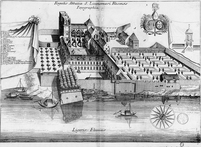
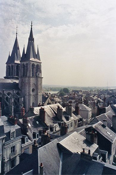
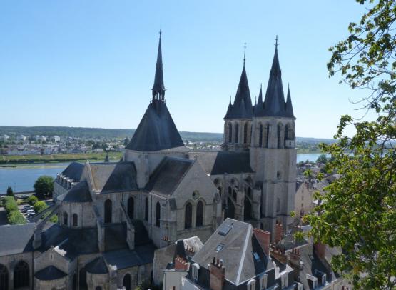
| Description | : | The abbey of St. Laumer, also known as "Saint-Lomer" or "ancien Hôtel-Dieu de Blois", is located on the "Quay of Father Gregory", in the city of Blois, which is situated in the department of "Loir-et-Cher". In A.D. 924, the monks of St. Laumer, of Blois pushed inland by the Norman invasions, were granted land beyond the walls of the city. It was not until the 13th century that the Benedictine Abbey of St. Laumer was built on the land which they'd occupied. In the 14th century, the abbey was fortified to escape the ravages of the "Hundred Years War". In... Read More |
frequently asked questions (FAQ):
-
Where is Abbaye Saint-Laumer de Blois?
Abbaye Saint-Laumer de Blois is located at Quai de l'Abbé Grégoire, Blois, Departement du Loir-et-Cher ,Centre , F-41000France.
-
Abbaye Saint-Laumer de Blois cemetery's updated grave count on graveviews.com?
0 memorials
-
Where are the coordinates of the Abbaye Saint-Laumer de Blois?
Latitude: 47.5837200
Longitude: 1.3318980
Nearby Cemetories:
1. Eglise Saint-Nicolas
Blois, Departement du Loir-et-Cher, France
Coordinate: 47.5841420, 1.3313960
2. Cimetiere Blois-Vienne
Blois, Departement du Loir-et-Cher, France
Coordinate: 47.5782200, 1.3394600
3. Cimetière Blois-Ville
Blois, Departement du Loir-et-Cher, France
Coordinate: 47.5894230, 1.3215856
4. Cimetière La-Forêt
Blois, Departement du Loir-et-Cher, France
Coordinate: 47.5918600, 1.2864761
5. Cimetière des Grouëts
Blois, Departement du Loir-et-Cher, France
Coordinate: 47.5550338, 1.2866732
6. Cimetière de Cellettes
Cellettes, Departement du Loir-et-Cher, France
Coordinate: 47.5317266, 1.3808086
7. Chapelle royale de Chambord
Chambord, Departement du Loir-et-Cher, France
Coordinate: 47.6159725, 1.5160940
8. Cimetière communal de Rilly-sur-Loire
Rilly-sur-Loire, Departement du Loir-et-Cher, France
Coordinate: 47.4668000, 1.1374000
9. Seris Communal Cemetery
Seris, Departement du Loir-et-Cher, France
Coordinate: 47.7565900, 1.5043200
10. Cimetiere Limeray
Limeray, Departement d'Indre-et-Loire, France
Coordinate: 47.4615163, 1.0433687
11. St. Laurent-des-Eaux Communal Cemetery
Saint-Laurent-Nouan, Departement du Loir-et-Cher, France
Coordinate: 47.7189600, 1.6164400
12. La Ferte-St. Cyr Communal Cemetery
La Ferte-Saint-Cyr, Departement du Loir-et-Cher, France
Coordinate: 47.6522700, 1.6716800
13. Vernou-en-Sologne Communal Cemetery
Vernou-en-Sologne, Departement du Loir-et-Cher, France
Coordinate: 47.5039800, 1.6815900
14. Église Notre-Dame de Nanteuil
Montrichard, Departement du Loir-et-Cher, France
Coordinate: 47.3436000, 1.1842000
15. Church of Saint-Georges (Defunct)
Vendome, Departement du Loir-et-Cher, France
Coordinate: 47.7891290, 1.0655560
16. Abbaye de la Trinité
Vendome, Departement du Loir-et-Cher, France
Coordinate: 47.7911110, 1.0688890
17. Collégiale Saint-Georges
Vendome, Departement du Loir-et-Cher, France
Coordinate: 47.7936110, 1.0663890
18. Chateau Renault Communal Cemetery
Chateau-Renault, Departement d'Indre-et-Loire, France
Coordinate: 47.5980800, 0.9118300
19. Vendome Town Cemetery
Vendome, Departement du Loir-et-Cher, France
Coordinate: 47.8052110, 1.0682970
20. Cimetière de Beaugency
Beaugency, Departement du Loiret, France
Coordinate: 47.7828700, 1.6350900
21. Chapelle Saint Hubert
Amboise, Departement d'Indre-et-Loire, France
Coordinate: 47.4129640, 0.9857170
22. Amboise Église Saint-Florentin
Amboise, Departement d'Indre-et-Loire, France
Coordinate: 47.4129100, 0.9834890
23. Cimetière d'Amboise
Amboise, Departement d'Indre-et-Loire, France
Coordinate: 47.3982410, 0.9672830
24. Noyers Communal Cemetery
Noyers-sur-Cher, Departement du Loir-et-Cher, France
Coordinate: 47.2728900, 1.4077400