
| Memorials | : | 0 |
| Location | : | Republic, Seneca County, USA |
| Coordinate | : | 41.1824646, -82.9758987 |
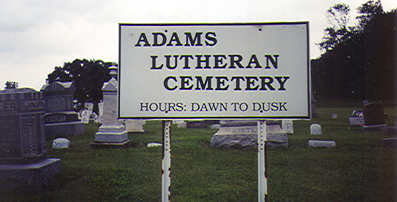
| Description | : | Adams/Zion Cemetery is located 1 1/2 miles south of Lowell and 4 miles west on the corner of Snavely Road and County Road 21 The cemetery is located in Adams Township, Seneca County, Ohio, and is # 11064 (Adams Lutheran Cemetery / Zion Lutheran Cemetery) in “Ohio Cemeteries 1803-2003”, compiled by the Ohio Genealogical Society. The U.S. Geological Survey (USGS) Geographic Names Information System (GNIS) feature ID for the cemetery is 1730834 (Adams Lutheran Cemetery / Zion Lutheran Cemetery). |
frequently asked questions (FAQ):
-
Where is Adams Lutheran Cemetery?
Adams Lutheran Cemetery is located at County Road 21 Republic, Seneca County ,Ohio , 44867USA.
-
Adams Lutheran Cemetery cemetery's updated grave count on graveviews.com?
0 memorials
-
Where are the coordinates of the Adams Lutheran Cemetery?
Latitude: 41.1824646
Longitude: -82.9758987
Nearby Cemetories:
1. Block Cemetery
Republic, Seneca County, USA
Coordinate: 41.1753006, -82.9772034
2. Payne Cemetery
Seneca County, USA
Coordinate: 41.1986690, -82.9750770
3. Reformed Church Cemetery
West Lodi, Seneca County, USA
Coordinate: 41.1653980, -82.9809600
4. Union Cemetery
Seneca County, USA
Coordinate: 41.2118988, -82.9710999
5. Clay-Groscost Cemetery
Seneca County, USA
Coordinate: 41.1455130, -82.9813030
6. Coffman Cemetery
Seneca County, USA
Coordinate: 41.1693993, -83.0346985
7. Kohlenberg Family Cemetery
Republic, Seneca County, USA
Coordinate: 41.1840180, -83.0506650
8. Saint Jacob Cemetery
Republic, Seneca County, USA
Coordinate: 41.1700500, -83.0501900
9. Lowell School Cemetery
Green Springs, Seneca County, USA
Coordinate: 41.2131000, -83.0472000
10. Armstrong Cemetery
Seneca County, USA
Coordinate: 41.1246986, -82.9447021
11. Thompson Center Cemetery
Seneca County, USA
Coordinate: 41.2117004, -82.9024963
12. Fireside Cemetery
Seneca County, USA
Coordinate: 41.2270000, -82.9072100
13. Farewell Retreat Cemetery
Republic, Seneca County, USA
Coordinate: 41.1172800, -83.0132500
14. Lay Cemetery
Green Springs, Seneca County, USA
Coordinate: 41.2552986, -82.9816971
15. Raymond Cemetery
Green Springs, Seneca County, USA
Coordinate: 41.2495130, -83.0197690
16. Reed Assumption Catholic Church Cemetery
Reedtown, Seneca County, USA
Coordinate: 41.1531800, -82.8792000
17. Underhill Cemetery
Seneca County, USA
Coordinate: 41.2098030, -82.8758530
18. Bunker Hill Cemetery
Seneca County, USA
Coordinate: 41.2125015, -83.0772018
19. Colwell Cemetery
Green Creek, Sandusky County, USA
Coordinate: 41.2700005, -82.9800034
20. Bishop Seybert Cemetery
Flat Rock, Seneca County, USA
Coordinate: 41.2257996, -82.8739014
21. Scipio Township Cemetery
Scipio, Seneca County, USA
Coordinate: 41.0956110, -83.0054687
22. Pleasant Ridge Cemetery
Tiffin, Seneca County, USA
Coordinate: 41.1688995, -83.0986023
23. Saint Michaels Cemetery
Frank, Seneca County, USA
Coordinate: 41.1927986, -82.8514023
24. Watson Cemetery
Watson, Seneca County, USA
Coordinate: 41.1877620, -83.1044050