
| Memorials | : | 0 |
| Location | : | Huddersfield, Metropolitan Borough of Kirklees, England |
| Coordinate | : | 53.6428410, -1.8063770 |
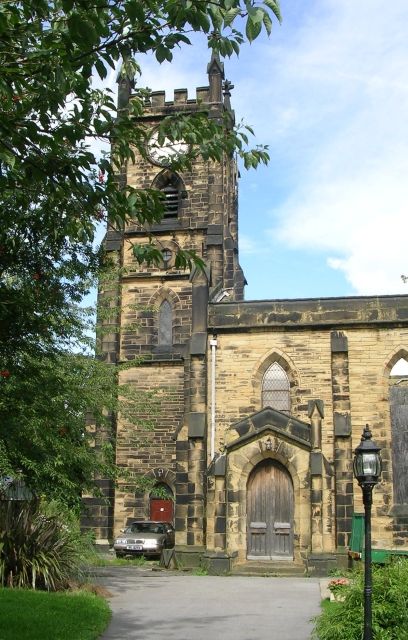
| Description | : | Located in the former village of Paddock (now a district of Huddersfield), All Saints Church was opened 1830. This was the second church built in the Huddersfield area in the early 19th century. It was declared redundant and sold in 1985. The building was converted into a residence called Kirke House. It is a Grade II listed building with Historic England. A burial register for Paddock All Saints for the years 1830 to 1942 is available. The architect of All Saints, John Oates, died in 1831 and was buried in the churchyard. |
frequently asked questions (FAQ):
-
Where is All Saints Churchyard?
All Saints Churchyard is located at Church Street Paddock Huddersfield, Metropolitan Borough of Kirklees ,West Yorkshire , HD1 4UBEngland.
-
All Saints Churchyard cemetery's updated grave count on graveviews.com?
0 memorials
-
Where are the coordinates of the All Saints Churchyard?
Latitude: 53.6428410
Longitude: -1.8063770
Nearby Cemetories:
1. Friends Burial Ground
Huddersfield, Metropolitan Borough of Kirklees, England
Coordinate: 53.6427300, -1.8041100
2. Holy Trinity Churchyard
Huddersfield, Metropolitan Borough of Kirklees, England
Coordinate: 53.6497300, -1.7928400
3. St Luke Churchyard
Milnsbridge, Metropolitan Borough of Kirklees, England
Coordinate: 53.6370540, -1.8214650
4. Lockwood Baptist Chapelyard
Lockwood, Metropolitan Borough of Kirklees, England
Coordinate: 53.6336200, -1.7955400
5. Edgerton Cemetery
Edgerton, Metropolitan Borough of Kirklees, England
Coordinate: 53.6535400, -1.7935100
6. New Conexion Chapel
Huddersfield, Metropolitan Borough of Kirklees, England
Coordinate: 53.6447670, -1.7843060
7. Emmanuel Churchyard
Lockwood, Metropolitan Borough of Kirklees, England
Coordinate: 53.6301400, -1.7957410
8. St Mark Churchyard
Huddersfield, Metropolitan Borough of Kirklees, England
Coordinate: 53.6459760, -1.8322580
9. St. Peter's Churchyard
Huddersfield, Metropolitan Borough of Kirklees, England
Coordinate: 53.6475760, -1.7809710
10. St Paul Churchyard
Huddersfield, Metropolitan Borough of Kirklees, England
Coordinate: 53.6438800, -1.7795800
11. Rose Hill Natural Burial Ground
Huddersfield, Metropolitan Borough of Kirklees, England
Coordinate: 53.6588400, -1.8029600
12. St. Stephen's Churchyard
Lindley, Metropolitan Borough of Kirklees, England
Coordinate: 53.6590210, -1.8222000
13. Lockwood Cemetery
Huddersfield, Metropolitan Borough of Kirklees, England
Coordinate: 53.6240290, -1.8069020
14. St John the Evangelist Churchyard
Newsome, Metropolitan Borough of Kirklees, England
Coordinate: 53.6280000, -1.7834300
15. Zion Methodist Chapelyard
Lindley, Metropolitan Borough of Kirklees, England
Coordinate: 53.6617100, -1.8236500
16. Lindley Methodist Chapelyard
Lindley, Metropolitan Borough of Kirklees, England
Coordinate: 53.6634200, -1.8219000
17. St Paul Churchyard
Armitage Bridge, Metropolitan Borough of Kirklees, England
Coordinate: 53.6193850, -1.7984590
18. St Philip the Apostle Churchyard
Huddersfield, Metropolitan Borough of Kirklees, England
Coordinate: 53.6657200, -1.8208100
19. Christ Church Memorial Garden
Moldgreen, Metropolitan Borough of Kirklees, England
Coordinate: 53.6457200, -1.7651400
20. Longwood Wesleyan Methodist Burial Ground
Golcar, Metropolitan Borough of Kirklees, England
Coordinate: 53.6525610, -1.8458385
21. Salendine Nook Baptist Chapelyard
Huddersfield, Metropolitan Borough of Kirklees, England
Coordinate: 53.6575200, -1.8417800
22. New Congregational Church
Moldgreen, Metropolitan Borough of Kirklees, England
Coordinate: 53.6433201, -1.7629206
23. Golcar Baptist Church
Golcar, Metropolitan Borough of Kirklees, England
Coordinate: 53.6357784, -1.8525264
24. Christ Church Cemetery and Churchyard
Linthwaite, Metropolitan Borough of Kirklees, England
Coordinate: 53.6260200, -1.8462000