
| Memorials | : | 0 |
| Location | : | Denmark, Madison County, USA |
| Coordinate | : | 35.5781270, -88.9140360 |
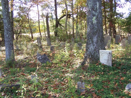
| Description | : | From the intersection of TN-223 S & US-70, west of Jackson, travel south on TN-223 S for 2.4 mi., turning east (left) onto Demark-Jackson Rd., going 0.7 mi. to a long narrow field on the south (right) side of the road. Walk due south for about 100 yards, along the east side of the field to the cemetery just inside the wooded area. It is fenced, but is overgrown & abandoned shape. |
frequently asked questions (FAQ):
-
Where is Alston-Johnson Cemetery?
Alston-Johnson Cemetery is located at Denmark-Jackson Road Denmark, Madison County ,Tennessee ,USA.
-
Alston-Johnson Cemetery cemetery's updated grave count on graveviews.com?
0 memorials
-
Where are the coordinates of the Alston-Johnson Cemetery?
Latitude: 35.5781270
Longitude: -88.9140360
Nearby Cemetories:
1. Cerro Gordo Missionary Baptist Church Cemetery
Jackson, Madison County, USA
Coordinate: 35.5795670, -88.8980160
2. Oak Grove M.B. Church Cemetery
Westover, Madison County, USA
Coordinate: 35.6023550, -88.8958160
3. Taylor Cemetery
Denmark, Madison County, USA
Coordinate: 35.5605280, -88.9485000
4. Benthall Cemetery
Westover, Madison County, USA
Coordinate: 35.5976650, -88.8774790
5. Oak Grove U.M. Church Cemetery
Westover, Madison County, USA
Coordinate: 35.6054280, -88.8847280
6. Robinson Family Cemetery
Jackson, Madison County, USA
Coordinate: 35.5823000, -88.8695420
7. Hall and King Cemetery
Madison County, USA
Coordinate: 35.5624720, -88.8689290
8. Sweeney Cemetery
Madison Hall, Madison County, USA
Coordinate: 35.5659000, -88.8672000
9. Freeman Family Cemetery
Jackson, Madison County, USA
Coordinate: 35.6171400, -88.9319300
10. Saint Mark Memorial Gardens
Westover, Madison County, USA
Coordinate: 35.6137450, -88.8801480
11. Hill Cemetery
Madison Hall, Madison County, USA
Coordinate: 35.5483240, -88.8723260
12. Mount Olive M.B. Church Cemetery
Denmark, Madison County, USA
Coordinate: 35.5508830, -88.9585400
13. Boon Cemetery
Madison County, USA
Coordinate: 35.5985720, -88.8629270
14. Tomlin Graves
Jackson, Madison County, USA
Coordinate: 35.5924000, -88.8576000
15. Johnson Cemetery
Jackson, Madison County, USA
Coordinate: 35.5303535, -88.9050598
16. Ararat Baptist Church Cemetery
Huntersville, Madison County, USA
Coordinate: 35.6117590, -88.9658580
17. Walnut Grove Baptist Church Cemetery
Jackson, Madison County, USA
Coordinate: 35.6301010, -88.9318230
18. Rope Field Burying Ground
Jackson, Madison County, USA
Coordinate: 35.5466000, -88.8538000
19. Andrews Chapel United Methodist Church Cemetery
Huntersville, Madison County, USA
Coordinate: 35.6128500, -88.9742900
20. Cane Creek Church Cemetery
Jackson, Madison County, USA
Coordinate: 35.5610720, -88.8379380
21. Bemis Cemetery
Madison County, USA
Coordinate: 35.5689011, -88.8324966
22. Blair's Chapel Cemetery
Medon, Madison County, USA
Coordinate: 35.5108420, -88.9049260
23. Blairs Chapel CME Cemetery
Medon, Madison County, USA
Coordinate: 35.5104780, -88.9053300
24. Bobbitt Memorial Garden
Medon, Madison County, USA
Coordinate: 35.5095650, -88.9087080