| Memorials | : | 0 |
| Location | : | Austrey, North Warwickshire Borough, England |
| Coordinate | : | 52.6551940, -1.5631710 |
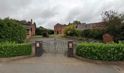
| Description | : | The church was built in 1819 for a church formed in 1808. It is now a Grade 11 listed building and is still in use today. |
frequently asked questions (FAQ):
-
Where is Austrey Baptist Church?
Austrey Baptist Church is located at Austrey, North Warwickshire Borough ,Warwickshire ,England.
-
Austrey Baptist Church cemetery's updated grave count on graveviews.com?
0 memorials
-
Where are the coordinates of the Austrey Baptist Church?
Latitude: 52.6551940
Longitude: -1.5631710
Nearby Cemetories:
1. St Nicholas' Churchyard
Austrey, North Warwickshire Borough, England
Coordinate: 52.6534340, -1.5644170
2. St Mary the Virgin Churchyard
Newton Regis, North Warwickshire Borough, England
Coordinate: 52.6642390, -1.5886760
3. St Mary the Virgin Churchyard
No Man's Heath, North Warwickshire Borough, England
Coordinate: 52.6770470, -1.5722540
4. St Edith's Churchyard
Orton-on-the-Hill, Hinckley and Bosworth Borough, England
Coordinate: 52.6321440, -1.5516440
5. Holy Trinity Churchyard
Warton, North Warwickshire Borough, England
Coordinate: 52.6292929, -1.5865304
6. All Saints Churchyard
Seckington, North Warwickshire Borough, England
Coordinate: 52.6638760, -1.6167310
7. St. Michael and All Angels Churchyard
Appleby Magna, North West Leicestershire District, England
Coordinate: 52.6854410, -1.5353870
8. Appleby Magna Cemetery
Appleby Magna, North West Leicestershire District, England
Coordinate: 52.6858670, -1.5358910
9. St. Matthew's Churchyard
Shuttington, North Warwickshire Borough, England
Coordinate: 52.6440000, -1.6244720
10. St James Churchyard
Twycross, Hinckley and Bosworth Borough, England
Coordinate: 52.6408460, -1.5008859
11. St Matthew Churchyard
Chilcote, North West Leicestershire District, England
Coordinate: 52.6995200, -1.5804990
12. Polesworth Abbey Churchyard
Polesworth, North Warwickshire Borough, England
Coordinate: 52.6193460, -1.6115790
13. All Saints Sheepy Magna Churchyard Extension
Sheepy, Hinckley and Bosworth Borough, England
Coordinate: 52.6171580, -1.5143390
14. St Michael Churchyard
Stretton en le Field, North West Leicestershire District, England
Coordinate: 52.7040970, -1.5516120
15. All Saints Churchyard
Grendon, North Warwickshire Borough, England
Coordinate: 52.6053560, -1.5769450
16. All Saints Churchyard
Sheepy, Hinckley and Bosworth Borough, England
Coordinate: 52.6090220, -1.5208910
17. Chapel of All Saints, Statfold
Thorpe Constantine, Lichfield District, England
Coordinate: 52.6611100, -1.6510330
18. St Peter Churchyard
Netherseal, South Derbyshire District, England
Coordinate: 52.7128960, -1.5741870
19. Amington Cemetery
Amington, Tamworth Borough, England
Coordinate: 52.6356092, -1.6552355
20. St. Laurence Courtyard
Measham, North West Leicestershire District, England
Coordinate: 52.7065910, -1.5053110
21. Measham Cemetery
Measham, North West Leicestershire District, England
Coordinate: 52.7041430, -1.4987930
22. St Leonard's Churchyard
Dordon, North Warwickshire Borough, England
Coordinate: 52.6004250, -1.6132720
23. St Mary Churchyard
Congerstone, Hinckley and Bosworth Borough, England
Coordinate: 52.6455630, -1.4590790
24. St Michael & St James Catholic Churchyard
Haunton, Lichfield District, England
Coordinate: 52.6946050, -1.6514690

