
| Memorials | : | 0 |
| Location | : | Bolesławiec, Powiat bolesławiecki, Poland |
| Coordinate | : | 50.9397320, 15.5957866 |
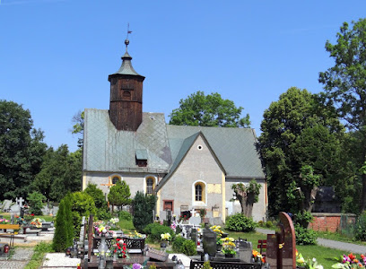
| Description | : | The Church of St. Michael in Barcinek (formerly Berthelsdorf) was first mentioned around 1400. Following the Reformation, the church passed into the hands of the Protestants, who undertook a major expansion and renovation of the building around 1600. After WWII, it once again again passed into the hands of the Catholic Church. The church is surrounded by a graveyard, and conserves a handful of Renaissance epitaphs. |
frequently asked questions (FAQ):
-
Where is Barcinek Church of St. Michael?
Barcinek Church of St. Michael is located at Barcinek Bolesławiec, Powiat bolesławiecki ,Dolnośląskie ,Poland.
-
Barcinek Church of St. Michael cemetery's updated grave count on graveviews.com?
0 memorials
-
Where are the coordinates of the Barcinek Church of St. Michael?
Latitude: 50.9397320
Longitude: 15.5957866
Nearby Cemetories:
1. Stara Kamienica Church of St. John the Baptist
Bolesławiec, Powiat bolesławiecki, Poland
Coordinate: 50.9196557, 15.5718010
2. Janice Protestant Cemetery
Bolesławiec, Powiat bolesławiecki, Poland
Coordinate: 50.9563051, 15.5339381
3. Mała Kamienica Church of St. Barbara
Bolesławiec, Powiat bolesławiecki, Poland
Coordinate: 50.9098210, 15.5433361
4. Kromnów Church of St. George
Bolesławiec, Powiat bolesławiecki, Poland
Coordinate: 50.8955308, 15.5792439
5. Radomice Church of Sts. James and Catherine
Bolesławiec, Powiat bolesławiecki, Poland
Coordinate: 50.9922307, 15.6085615
6. Kopaniec Church of St. Anthony of Padua
Bolesławiec, Powiat bolesławiecki, Poland
Coordinate: 50.8921302, 15.5516039
7. Siedlęcin Catholic Graveyard
Bolesławiec, Powiat bolesławiecki, Poland
Coordinate: 50.9359100, 15.6868000
8. Górska Street Cemetery
Wrocław, Miasto Wrocław, Poland
Coordinate: 51.0127290, 15.6728120
9. Wleński Gródek Church of St. Hedwig
Powiat lwówecki, Poland
Coordinate: 51.0163251, 15.6638356
10. Cieplice Church of St. John the Baptist
Powiat jeleniogórski, Poland
Coordinate: 50.8655695, 15.6788243
11. Cieplice-Zdrój Cemetery
Wrocław, Miasto Wrocław, Poland
Coordinate: 50.8684590, 15.6901290
12. Lubomierz Cemetery
Bolesławiec, Powiat bolesławiecki, Poland
Coordinate: 51.0157900, 15.5053200
13. Basilica of Sts. Erasmus and Pancratius
Powiat jeleniogórski, Poland
Coordinate: 50.9033733, 15.7368199
14. Sobieszów Parish Cemetery
Powiat jeleniogórski, Poland
Coordinate: 50.8475332, 15.6423525
15. Rębiszów Catholic Church Graveyard
Bolesławiec, Powiat bolesławiecki, Poland
Coordinate: 50.9532800, 15.4434700
16. Evangelical Cemetery of Jelenia Góra
Wrocław, Miasto Wrocław, Poland
Coordinate: 50.9048530, 15.7443090
17. Pławna Dolna Church Graveyard
Bolesławiec, Powiat bolesławiecki, Poland
Coordinate: 51.0513800, 15.5878000
18. Bystrzyca Evangelical Cemetery
Bolesławiec, Powiat bolesławiecki, Poland
Coordinate: 51.0307300, 15.7260900
19. Church of the Annunciation
Mirsk, Powiat lwówecki, Poland
Coordinate: 50.9689700, 15.3814000
20. Sosnówka Catholic Church Graveyard
Bolesławiec, Powiat bolesławiecki, Poland
Coordinate: 50.8231200, 15.7220600
21. Church of St. Hedwig
Gryfów Śląski, Powiat lwówecki, Poland
Coordinate: 51.0292397, 15.4152342
22. Wieża Protestant Cemetery
Bolesławiec, Powiat bolesławiecki, Poland
Coordinate: 51.0247600, 15.4092000
23. Gryfów Śląski Cemetery
Wrocław, Miasto Wrocław, Poland
Coordinate: 51.0313300, 15.4139900
24. Sobota Evangelical Graveyard
Bolesławiec, Powiat bolesławiecki, Poland
Coordinate: 51.0827800, 15.6714800