
| Memorials | : | 245 |
| Location | : | Basildon, Basildon District, England |
| Phone | : | 01268 584411 |
| Coordinate | : | 51.5627300, 0.5235600 |
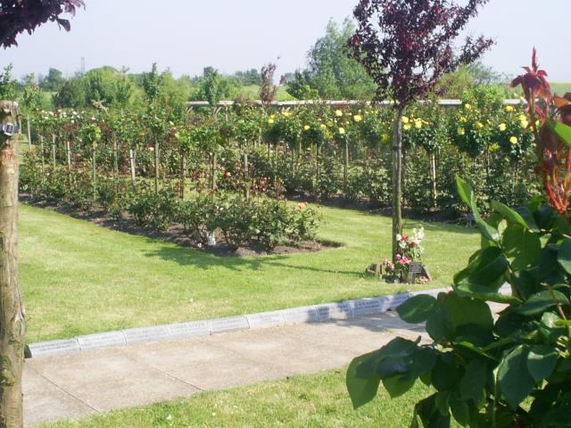
| Description | : | Basildon & District Crematorium Church Road, Bowers Gifford, Basildon, Essex, SS13 2HG The Crematorium was built in 1998 on Church Road north of the Bowers Marshes and occupies an eight acre site overlooking the Thames Estuary with views across to the Kent hills in the distance. Set inside Pitsea cemetery, it was developed in agreement with Basildon and District council. It is approached from the London Road east of Pitsea. Church Road crosses over the A13. Tel: 01268 584411, Fax: 01268 584422, email [email protected] |
frequently asked questions (FAQ):
-
Where is Basildon Crematorium?
Basildon Crematorium is located at Church Road Basildon, Basildon District ,Essex , SS13 2HGEngland.
-
Basildon Crematorium cemetery's updated grave count on graveviews.com?
245 memorials
-
Where are the coordinates of the Basildon Crematorium?
Latitude: 51.5627300
Longitude: 0.5235600
Nearby Cemetories:
1. Pitsea Cemetery
Pitsea, Basildon District, England
Coordinate: 51.5641840, 0.5243510
2. St. Margaret of Antioch Churchyard
Pitsea, Basildon District, England
Coordinate: 51.5569160, 0.5309590
3. St. Michael's Churchyard
Pitsea, Basildon District, England
Coordinate: 51.5620520, 0.5067230
4. South Benfleet Cemetery
South Benfleet, Castle Point Borough, England
Coordinate: 51.5556220, 0.5501750
5. All Saints Churchyard
North Benfleet, Basildon District, England
Coordinate: 51.5813200, 0.5403260
6. St. Peter's Churchyard
Nevendon, Basildon District, England
Coordinate: 51.5885080, 0.5378120
7. St. Mary the Virgin Churchyard
South Benfleet, Castle Point Borough, England
Coordinate: 51.5461020, 0.5630390
8. St Peter Churchyard
Thundersley, Castle Point Borough, England
Coordinate: 51.5687940, 0.5710100
9. All Saints Churchyard
Vange, Basildon District, England
Coordinate: 51.5533240, 0.4723390
10. Willow Cemetery
Canvey Island, Castle Point Borough, England
Coordinate: 51.5250060, 0.5440810
11. St Michael Churchyard
Fobbing, Thurrock Unitary Authority, England
Coordinate: 51.5278690, 0.4752220
12. St. Katherine Churchyard
Canvey Island, Castle Point Borough, England
Coordinate: 51.5207340, 0.5626850
13. Corringham Cemetery
Corringham, Thurrock Unitary Authority, England
Coordinate: 51.5268450, 0.4651920
14. St James the Less Churchyard
Hadleigh, Castle Point Borough, England
Coordinate: 51.5530400, 0.6095590
15. St. Mary the Virgin Churchyard
Corringham, Thurrock Unitary Authority, England
Coordinate: 51.5225460, 0.4631320
16. Daws Heath Evangelical Churchyard
Daws Heath, Castle Point Borough, England
Coordinate: 51.5673560, 0.6136020
17. St Nicholas Churchyard
Rawreth, Rochford District, England
Coordinate: 51.6115180, 0.5702160
18. St Nicholas Churchyard
Laindon, Basildon District, England
Coordinate: 51.5792046, 0.4341750
19. Convent of the Good Shepherd
Canvey Island, Castle Point Borough, England
Coordinate: 51.5214345, 0.5899587
20. Holy Trinity Churchyard
Rayleigh, Rochford District, England
Coordinate: 51.5879958, 0.6085753
21. St Mary Churchyard
Runwell, Chelmsford Borough, England
Coordinate: 51.6211190, 0.5318030
22. Canvey Island 1953 Flood Memorial
Canvey Island, Castle Point Borough, England
Coordinate: 51.5231500, 0.5930740
23. St Mary Churchyard
Ramsden Crays, Basildon District, England
Coordinate: 51.6123140, 0.4656740
24. St. Mary the Virgin Churchyard
Ramsden Bellhouse, Basildon District, England
Coordinate: 51.6210300, 0.4821470