
| Memorials | : | 0 |
| Location | : | Canvey Island, Castle Point Borough, England |
| Coordinate | : | 51.5231500, 0.5930740 |
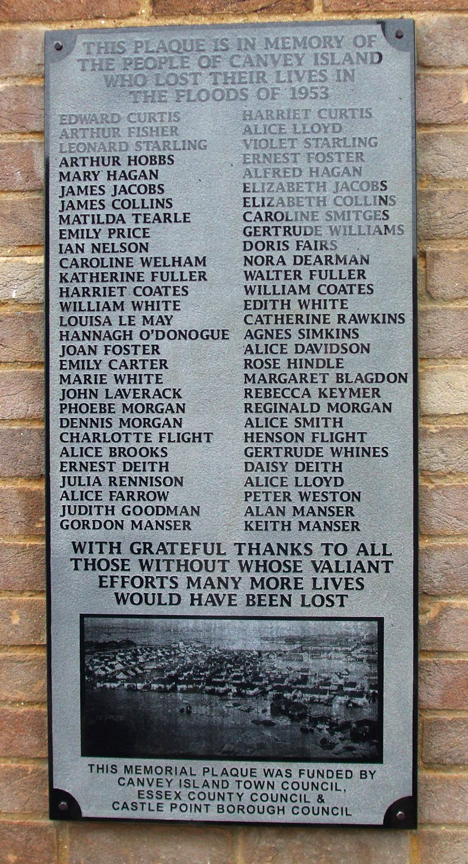
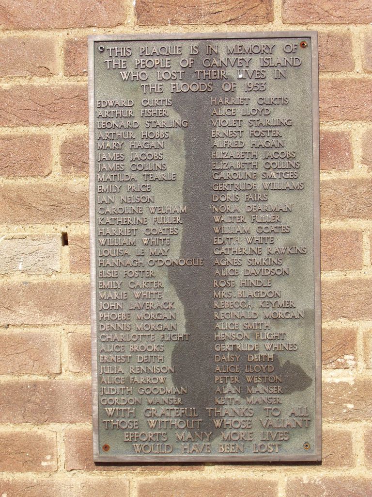
| Description | : | Tragedy hit Canvey Island during the night of 31 January 1953 when flood waters breached its then meagre sea defences. 58 people lost their lives that terrible night and 13,000 people were evacuated. This recently renovated memorial which is situated on the wall of the island's library, honours those lives lost. The people of Canvey Island came together on the 1st February 2011 for a service of Remembrance for those who died in the Canvey Island Floods of February 1st 1953 and the unveiling of a new plaque to remember the 58 who died. The service was held outside the... Read More |
frequently asked questions (FAQ):
-
Where is Canvey Island 1953 Flood Memorial?
Canvey Island 1953 Flood Memorial is located at Outside Library High Street Canvey Island, Castle Point Borough ,Essex , SS8 7RBEngland.
-
Canvey Island 1953 Flood Memorial cemetery's updated grave count on graveviews.com?
0 memorials
-
Where are the coordinates of the Canvey Island 1953 Flood Memorial?
Latitude: 51.5231500
Longitude: 0.5930740
Nearby Cemetories:
1. Convent of the Good Shepherd
Canvey Island, Castle Point Borough, England
Coordinate: 51.5214345, 0.5899587
2. St. Katherine Churchyard
Canvey Island, Castle Point Borough, England
Coordinate: 51.5207340, 0.5626850
3. St. Mary the Virgin Churchyard
South Benfleet, Castle Point Borough, England
Coordinate: 51.5461020, 0.5630390
4. Willow Cemetery
Canvey Island, Castle Point Borough, England
Coordinate: 51.5250060, 0.5440810
5. St James the Less Churchyard
Hadleigh, Castle Point Borough, England
Coordinate: 51.5530400, 0.6095590
6. South Benfleet Cemetery
South Benfleet, Castle Point Borough, England
Coordinate: 51.5556220, 0.5501750
7. St. Clement's Churchyard
Leigh-on-Sea, Southend-on-Sea Unitary Authority, England
Coordinate: 51.5412990, 0.6542310
8. Leigh Cemetery
Leigh-on-Sea, Southend-on-Sea Unitary Authority, England
Coordinate: 51.5481500, 0.6496740
9. Daws Heath Evangelical Churchyard
Daws Heath, Castle Point Borough, England
Coordinate: 51.5673560, 0.6136020
10. St Peter Churchyard
Thundersley, Castle Point Borough, England
Coordinate: 51.5687940, 0.5710100
11. St. Margaret of Antioch Churchyard
Pitsea, Basildon District, England
Coordinate: 51.5569160, 0.5309590
12. Basildon Crematorium
Basildon, Basildon District, England
Coordinate: 51.5627300, 0.5235600
13. Pitsea Cemetery
Pitsea, Basildon District, England
Coordinate: 51.5641840, 0.5243510
14. St Mary Churchyard
St Mary Hoo, Medway Unitary Authority, England
Coordinate: 51.4595390, 0.5948850
15. All Saints Churchyard
Allhallows, Medway Unitary Authority, England
Coordinate: 51.4670950, 0.6417880
16. Holy Trinity Churchyard
Rayleigh, Rochford District, England
Coordinate: 51.5879958, 0.6085753
17. St. Michael's Churchyard
Pitsea, Basildon District, England
Coordinate: 51.5620520, 0.5067230
18. All Saints Churchyard
North Benfleet, Basildon District, England
Coordinate: 51.5813200, 0.5403260
19. North Road Burial Ground
Westcliff-on-Sea, Southend-on-Sea Unitary Authority, England
Coordinate: 51.5428130, 0.7024620
20. Rochford District Council Cemetery
Rayleigh, Rochford District, England
Coordinate: 51.5936500, 0.6135600
21. St Laurence and All Saints Churchyard
Eastwood, Southend-on-Sea Unitary Authority, England
Coordinate: 51.5677030, 0.6847360
22. St Michael Churchyard
Fobbing, Thurrock Unitary Authority, England
Coordinate: 51.5278690, 0.4752220
23. St. Peter's Churchyard
Nevendon, Basildon District, England
Coordinate: 51.5885080, 0.5378120
24. Lower Stoke Methodist Chapelyard
Stoke, Medway Unitary Authority, England
Coordinate: 51.4537680, 0.6336680