
| Memorials | : | 61 |
| Location | : | North Benfleet, Basildon District, England |
| Coordinate | : | 51.5813200, 0.5403260 |
| Description | : | North Benfleet is a village in the Basildon district of Essex, England. The name of the town originates from the time of the Saxon settlers in the 5th Century who named the area Beamfleote, meaning "tree stream", being the area where the creeks from the River Thames adjoined the wooded area to the north. The current spelling was adopted at the time the railway service was brought to the area and a railway station built for the town. Throughout the intervening period various documented versions of the names has been 'Benfleota', 'Beamflet', 'Bemflet', 'Bienflet' and 'Bemfleet'. In Roman times the... Read More |
frequently asked questions (FAQ):
-
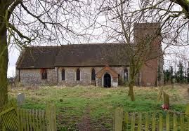
Where is All Saints Churchyard?
All Saints Churchyard is located at North Benfleet, Basildon District ,Essex ,England.
-
All Saints Churchyard cemetery's updated grave count on graveviews.com?
61 memorials
-
Where are the coordinates of the All Saints Churchyard?
Latitude: 51.5813200
Longitude: 0.5403260
Nearby Cemetories:
1. St. Peter's Churchyard
Nevendon, Basildon District, England
Coordinate: 51.5885080, 0.5378120
2. Pitsea Cemetery
Pitsea, Basildon District, England
Coordinate: 51.5641840, 0.5243510
3. Basildon Crematorium
Basildon, Basildon District, England
Coordinate: 51.5627300, 0.5235600
4. St Peter Churchyard
Thundersley, Castle Point Borough, England
Coordinate: 51.5687940, 0.5710100
5. St. Margaret of Antioch Churchyard
Pitsea, Basildon District, England
Coordinate: 51.5569160, 0.5309590
6. South Benfleet Cemetery
South Benfleet, Castle Point Borough, England
Coordinate: 51.5556220, 0.5501750
7. St. Michael's Churchyard
Pitsea, Basildon District, England
Coordinate: 51.5620520, 0.5067230
8. St Nicholas Churchyard
Rawreth, Rochford District, England
Coordinate: 51.6115180, 0.5702160
9. St. Mary the Virgin Churchyard
South Benfleet, Castle Point Borough, England
Coordinate: 51.5461020, 0.5630390
10. St Mary Churchyard
Runwell, Chelmsford Borough, England
Coordinate: 51.6211190, 0.5318030
11. Holy Trinity Churchyard
Rayleigh, Rochford District, England
Coordinate: 51.5879958, 0.6085753
12. Rochford District Council Cemetery
Rayleigh, Rochford District, England
Coordinate: 51.5936500, 0.6135600
13. Daws Heath Evangelical Churchyard
Daws Heath, Castle Point Borough, England
Coordinate: 51.5673560, 0.6136020
14. All Saints Churchyard
Vange, Basildon District, England
Coordinate: 51.5533240, 0.4723390
15. St James the Less Churchyard
Hadleigh, Castle Point Borough, England
Coordinate: 51.5530400, 0.6095590
16. St. Mary the Virgin Churchyard
Ramsden Bellhouse, Basildon District, England
Coordinate: 51.6210300, 0.4821470
17. All Saints Churchyard
Rettendon, Chelmsford Borough, England
Coordinate: 51.6349940, 0.5566860
18. St. Margaret's Churchyard
Downham, Chelmsford Borough, England
Coordinate: 51.6295580, 0.4981670
19. St Mary Churchyard
Ramsden Crays, Basildon District, England
Coordinate: 51.6123140, 0.4656740
20. Willow Cemetery
Canvey Island, Castle Point Borough, England
Coordinate: 51.5250060, 0.5440810
21. St. Katherine Churchyard
Canvey Island, Castle Point Borough, England
Coordinate: 51.5207340, 0.5626850
22. St Peter and St Paul Churchyard
Hockley, Rochford District, England
Coordinate: 51.6098370, 0.6356820
23. St Nicholas Churchyard
Laindon, Basildon District, England
Coordinate: 51.5792046, 0.4341750
24. Canvey Island 1953 Flood Memorial
Canvey Island, Castle Point Borough, England
Coordinate: 51.5231500, 0.5930740