
| Memorials | : | 20 |
| Location | : | Carroll County, USA |
| Coordinate | : | 40.6068993, -81.1686020 |
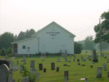
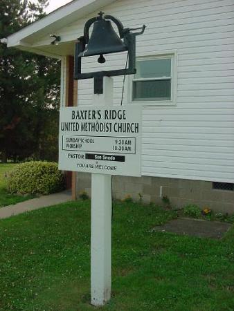
| Description | : | The cemetery is located on the northwest corner of the intersection of Jade Road NW (Township Road 194) and Avalon Road NW (County Road 20). The cemetery is located in Harrison Township, Carroll County, Ohio, and is # 1417 (Baxter Ridge Cemetery / Baxters Ridge Cemetery) in “Ohio Cemeteries 1803-2003”, compiled by the Ohio Genealogical Society. The cemetery is registered with the Ohio Division of Real Estate and Professional Licensing (ODRE) as Baxter Ridge with registration license number CGR.0000980345. The U.S. Geological Survey (USGS) Geographic Names Information System (GNIS) feature ID for the cemetery is 1052432 (Baxters Ridge... Read More |
frequently asked questions (FAQ):
-
Where is Baxters Ridge Cemetery?
Baxters Ridge Cemetery is located at Jade Road NW (Township Road 194) and Avalon Road NW (County Road 20) Carroll County ,Ohio , 44615USA.
-
Baxters Ridge Cemetery cemetery's updated grave count on graveviews.com?
20 memorials
-
Where are the coordinates of the Baxters Ridge Cemetery?
Latitude: 40.6068993
Longitude: -81.1686020

Nearby Cemetories:
1. New Harrisburg Cemetery
New Harrisburg, Carroll County, USA
Coordinate: 40.6208000, -81.1483002
2. Macedonia Cemetery
Carroll County, USA
Coordinate: 40.6217003, -81.1994019
3. Pleasant Valley Cemetery
Carroll County, USA
Coordinate: 40.5764008, -81.1493988
4. Woods Cemetery
Carroll County, USA
Coordinate: 40.6377983, -81.1947021
5. Wherry Cemetery
Stemple, Carroll County, USA
Coordinate: 40.6156006, -81.1063995
6. Piecynski Farm Cemetery
Carrollton, Carroll County, USA
Coordinate: 40.5658690, -81.1224020
7. Champers Cemetery
Carrollton, Carroll County, USA
Coordinate: 40.5667610, -81.1178540
8. McGuire Cemetery
Tabor, Carroll County, USA
Coordinate: 40.5518990, -81.1564026
9. Union Valley Cemetery
Carroll County, USA
Coordinate: 40.5758018, -81.2332993
10. Hites Cemetery
Carroll County, USA
Coordinate: 40.5942001, -81.2450027
11. Old Scott Cemetery
Carroll County, USA
Coordinate: 40.5483017, -81.1541977
12. Saint Marys of Morges Catholic Cemetery
Morges, Carroll County, USA
Coordinate: 40.6342800, -81.2423490
13. Immaculate Heart of Mary Cemetery
Carrollton, Carroll County, USA
Coordinate: 40.5758010, -81.0955510
14. Pleasant Grove Cemetery
Carroll County, USA
Coordinate: 40.6589012, -81.1089020
15. Farnsworth Cemetery
Carroll County, USA
Coordinate: 40.5385017, -81.1567001
16. Scotts Cemetery
Carroll County, USA
Coordinate: 40.5386009, -81.1556015
17. Harsh-Swamp Cemetery
Carroll County, USA
Coordinate: 40.6413994, -81.0892029
18. Harmony Cemetery
Carroll County, USA
Coordinate: 40.6082993, -81.2624969
19. Devils Half Acre Cemetery
Oneida, Carroll County, USA
Coordinate: 40.6697006, -81.1235962
20. Aller Family Cemetery
Carrollton, Carroll County, USA
Coordinate: 40.5879760, -81.0771540
21. Westview Cemetery
Carrollton, Carroll County, USA
Coordinate: 40.5663986, -81.0852966
22. Grandview Cemetery
Carrollton, Carroll County, USA
Coordinate: 40.5694008, -81.0828018
23. Seceders Cemetery
Carroll County, USA
Coordinate: 40.5332985, -81.1446991
24. Saint Luke Cemetery
Carroll County, USA
Coordinate: 40.5303001, -81.1810989