
| Memorials | : | 48 |
| Location | : | Steubenville, Jefferson County, USA |
| Coordinate | : | 40.3744011, -80.6572037 |
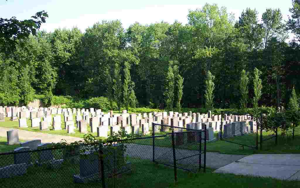
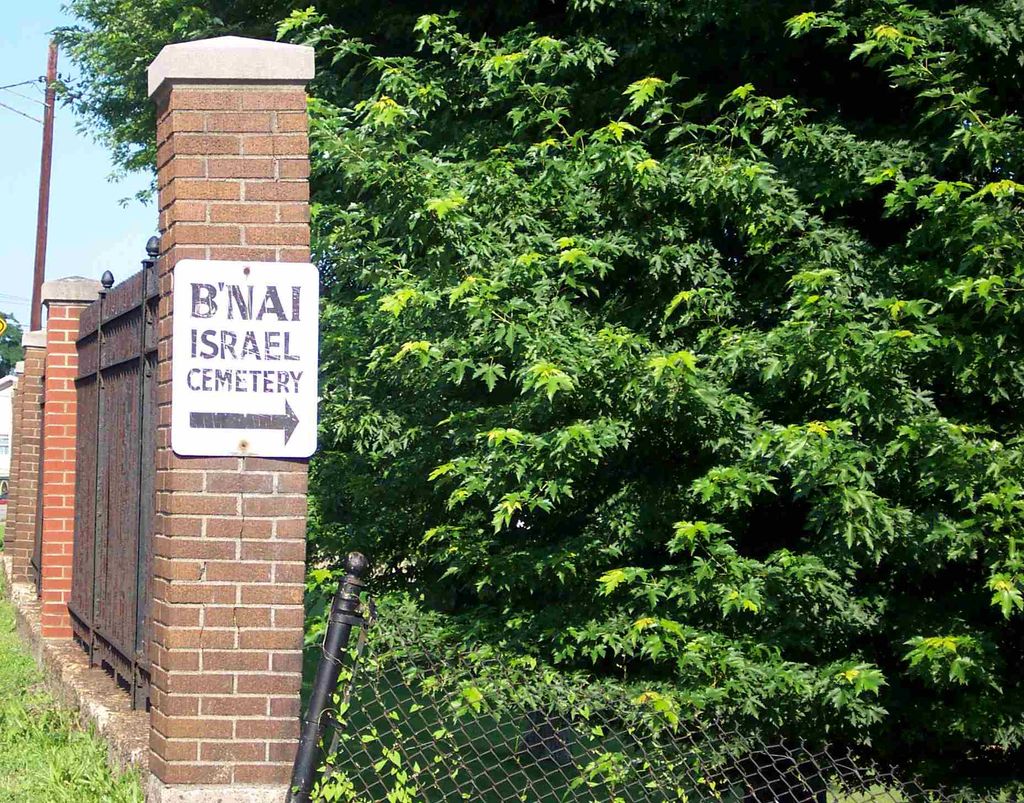
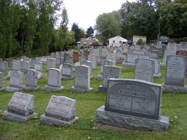
| Description | : | The cemetery is located on the northwest corner of the intersection of Cleveland Avenue and Sunset Boulevard (Ohio State Route 43). The cemetery is located in Cross Creek Township, Jefferson County, Ohio, and is # 6006 (B’nai Israel Cemetery / Jewish Cemetery) in “Ohio Cemeteries 1803-2003”, compiled by the Ohio Genealogical Society. The cemetery is registered with the Ohio Division of Real Estate and Professional Licensing (ODRE) as B’nai Israel Cemetery with registration license number CGR.2015004972. The U.S. Geological Survey (USGS) Geographic Names Information System (GNIS) feature ID for the cemetery is 1051078 (Bnai Israel Cemetery). |
frequently asked questions (FAQ):
-
Where is Bnai Israel Cemetery?
Bnai Israel Cemetery is located at Cleveland Avenue and Sunset Boulevard (Ohio State Route 43) Steubenville, Jefferson County ,Ohio , 43952USA.
-
Bnai Israel Cemetery cemetery's updated grave count on graveviews.com?
48 memorials
-
Where are the coordinates of the Bnai Israel Cemetery?
Latitude: 40.3744011
Longitude: -80.6572037
Nearby Cemetories:
1. Holy Resurrection Serbian Eastern Orthodox Church
Steubenville, Jefferson County, USA
Coordinate: 40.3760986, -80.6580963
2. Jefferson County Infirmary Cemetery
Steubenville, Jefferson County, USA
Coordinate: 40.3748880, -80.6725990
3. Mount Calvary Cemetery
Steubenville, Jefferson County, USA
Coordinate: 40.3643990, -80.6466980
4. Union Cemetery
Steubenville, Jefferson County, USA
Coordinate: 40.3636017, -80.6399994
5. Tomb of the Unborn Child
Steubenville, Jefferson County, USA
Coordinate: 40.3753230, -80.6199840
6. Cross Creek Cemetery
Wintersville, Jefferson County, USA
Coordinate: 40.3492928, -80.6872635
7. Wintersville United Methodist Church Cemetery
Wintersville, Jefferson County, USA
Coordinate: 40.3755360, -80.7064440
8. Coulter Cemetery
Wintersville, Jefferson County, USA
Coordinate: 40.4000970, -80.7014690
9. Highland Hills Memorial Gardens
Follansbee, Brooke County, USA
Coordinate: 40.3579480, -80.6038500
10. Fort Steuben Burial Estates
Wintersville, Jefferson County, USA
Coordinate: 40.3891983, -80.7236023
11. Hill Cemetery
Steubenville, Jefferson County, USA
Coordinate: 40.3233490, -80.6353580
12. Oakland Cemetery
Mingo Junction, Jefferson County, USA
Coordinate: 40.3285790, -80.6184240
13. Saint Andrews Cemetery
Mingo Junction, Jefferson County, USA
Coordinate: 40.3250008, -80.6172028
14. Center Chapel Cemetery
Island Creek Township, Jefferson County, USA
Coordinate: 40.4276600, -80.6942300
15. Two Ridges Cemetery
Wintersville, Jefferson County, USA
Coordinate: 40.3944016, -80.7328033
16. Oak Grove Cemetery
Follansbee, Brooke County, USA
Coordinate: 40.3274994, -80.5766983
17. Georges Run Cemetery
Steubenville, Jefferson County, USA
Coordinate: 40.3022920, -80.6189630
18. New Alexandria Cemetery
New Alexandria, Jefferson County, USA
Coordinate: 40.2949982, -80.6781006
19. Longs Methodist Episcopal Cemetery
Jefferson County, USA
Coordinate: 40.3203400, -80.7400100
20. Serbian Orthodox Cemetery
Weirton, Hancock County, USA
Coordinate: 40.4166320, -80.5623760
21. Saint Paul Catholic Cemetery
Weirton, Hancock County, USA
Coordinate: 40.4174995, -80.5616989
22. Saint John Cemetery Haven of Rest
Colliers, Brooke County, USA
Coordinate: 40.3486160, -80.5502720
23. Three Springs Cemetery
Weirton, Hancock County, USA
Coordinate: 40.4035988, -80.5503006
24. Our Lady of Sorrows Cemetery
Island Creek Township, Jefferson County, USA
Coordinate: 40.4634580, -80.6407320