
| Memorials | : | 0 |
| Location | : | Borculo, Berkelland Municipality, Netherlands |
| Coordinate | : | 52.1183000, 6.5198400 |
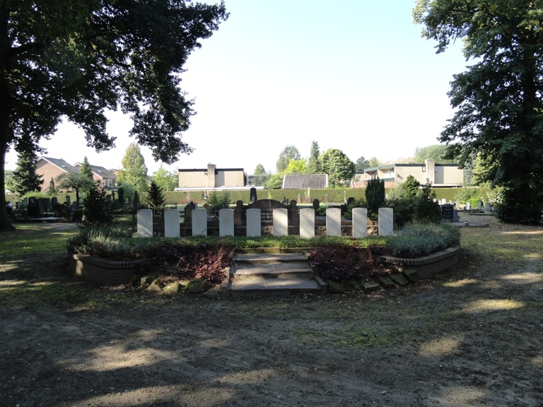
| Description | : | Borculo is a small town about 60 kilometres north-east of Arnhem and 22 kilometres east of Zutphen. The cemetery lies 182 metres north-north-west of the town hall. Ten war graves are located in a small memorial park in a prominent position facing the cemetery entrance. The local authorities erected special headstones over the war graves. |
frequently asked questions (FAQ):
-
Where is Borculo General Cemetery?
Borculo General Cemetery is located at Borculo, Berkelland Municipality ,Gelderland ,Netherlands.
-
Borculo General Cemetery cemetery's updated grave count on graveviews.com?
0 memorials
-
Where are the coordinates of the Borculo General Cemetery?
Latitude: 52.1183000
Longitude: 6.5198400
Nearby Cemetories:
1. Joodse Begraafplaats
Borculo, Berkelland Municipality, Netherlands
Coordinate: 52.1199100, 6.5173000
2. Begraafplaats Haarlo
Haarlo, Berkelland Municipality, Netherlands
Coordinate: 52.1105311, 6.5814055
3. Ruurlo General Cemetery
Ruurlo, Berkelland Municipality, Netherlands
Coordinate: 52.0916500, 6.4642800
4. Barchem General Cemetery
Barchem, Lochem Municipality, Netherlands
Coordinate: 52.1246000, 6.4415400
5. Drostenkamp Cemetery
Neede, Berkelland Municipality, Netherlands
Coordinate: 52.1435200, 6.5936000
6. Ruurlo Achter Zieuwent Roman Catholic Churchyard
Ruurlo, Berkelland Municipality, Netherlands
Coordinate: 52.0833700, 6.4508500
7. Joodse Begraafplaats
Lochem Municipality, Netherlands
Coordinate: 52.1566170, 6.4106750
8. Diepenheim New General Cemetery
Diepenheim, Hof van Twente Municipality, Netherlands
Coordinate: 52.1971200, 6.5427900
9. Lochem Nieuwe Begraafplaats
Lochem, Lochem Municipality, Netherlands
Coordinate: 52.1497700, 6.3964500
10. Eibergen Protestant Cemetery
Eibergen, Berkelland Municipality, Netherlands
Coordinate: 52.1125000, 6.6534600
11. Joodse begraafplaats
Eibergen, Berkelland Municipality, Netherlands
Coordinate: 52.1063400, 6.6546300
12. Nieuwe Hervormde Begraafplaats
Groenlo, Oost Gelre Municipality, Netherlands
Coordinate: 52.0455970, 6.6166189
13. Joodse Begraafplaats
Diepenheim, Hof van Twente Municipality, Netherlands
Coordinate: 52.2102900, 6.5517900
14. Joodse Begraafsplaats
Groenlo, Oost Gelre Municipality, Netherlands
Coordinate: 52.0448890, 6.6163030
15. Groenlo Roman Catholic Cemetery
Groenlo, Oost Gelre Municipality, Netherlands
Coordinate: 52.0350700, 6.6137700
16. Joodse Begraafplaats
Vorden, Bronckhorst Municipality, Netherlands
Coordinate: 52.1141700, 6.3546100
17. Vorden General Cemetery
Vorden, Bronckhorst Municipality, Netherlands
Coordinate: 52.1110620, 6.3307630
18. Markelo General Cemetery
Markelo, Hof van Twente Municipality, Netherlands
Coordinate: 52.2344500, 6.5029900
19. Goor New General Cemetery
Goor, Hof van Twente Municipality, Netherlands
Coordinate: 52.2353900, 6.5581200
20. Rekken Roman Catholic Cemetery
Rekken, Berkelland Municipality, Netherlands
Coordinate: 52.0925300, 6.7145700
21. Goor Roman Catholic Cemetery
Goor, Hof van Twente Municipality, Netherlands
Coordinate: 52.2335800, 6.5932700
22. Joodse begraafplaats
Goor, Hof van Twente Municipality, Netherlands
Coordinate: 52.2365100, 6.5889600
23. Israelitische Begraafplaats
Haaksbergen, Haaksbergen Municipality, Netherlands
Coordinate: 52.1604900, 6.7338300
24. Lichtenvoorde General Cemetery
Lichtenvoorde, Oost Gelre Municipality, Netherlands
Coordinate: 51.9886300, 6.5968600