| Memorials | : | 20 |
| Location | : | Brillion, Calumet County, USA |
| Coordinate | : | 44.1642120, -88.0741630 |
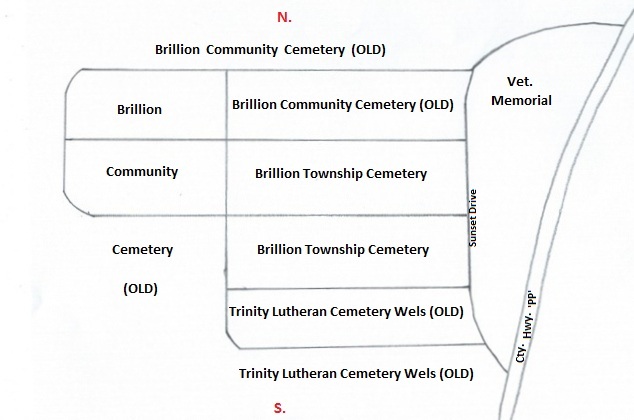
| Description | : | The cemetery property on the south side of the village of Brillion, on the curve, on the west side of County Hwy. ‘PP', is actually three individual cemeteries, not one as it appears. They are, from left to right as you face the cemetery from the road; Trinity Lutheran Cemetery Wels (Old), Brillion Township Cemetery, Brillion Community Cemetery (Old). The three cemeteries are plainly separated by 5 roads that go east and west that creates 6 grave sections and one road that goes north and south separating the front sections from the back. Each cemetery has 2 sections of their own in the... Read More |
frequently asked questions (FAQ):
-
Where is Brillion Township Cemetery?
Brillion Township Cemetery is located at Brillion, Calumet County ,Wisconsin ,USA.
-
Brillion Township Cemetery cemetery's updated grave count on graveviews.com?
20 memorials
-
Where are the coordinates of the Brillion Township Cemetery?
Latitude: 44.1642120
Longitude: -88.0741630
Nearby Cemetories:
1. Brillion Village Cemetery
Brillion, Calumet County, USA
Coordinate: 44.1642160, -88.0742060
2. Trinity Lutheran Cemetery Old
Brillion, Calumet County, USA
Coordinate: 44.1641100, -88.0741100
3. Brillion Community Cemetery
Brillion, Calumet County, USA
Coordinate: 44.1618880, -88.0737880
4. Trinity Lutheran Cemetery New
Brillion, Calumet County, USA
Coordinate: 44.1604100, -88.0738300
5. Holy Family Parish Cemetery
Brillion, Calumet County, USA
Coordinate: 44.1899986, -88.0599976
6. Free German Cemetery
Potter, Calumet County, USA
Coordinate: 44.1236000, -88.0849991
7. Holy Trinity Cemetery
Maple Grove, Manitowoc County, USA
Coordinate: 44.2111015, -88.0346985
8. Trinity Lutheran Church Cemetery
Potter, Calumet County, USA
Coordinate: 44.1095900, -88.0934430
9. Bluff Cemetery
Brillion, Calumet County, USA
Coordinate: 44.2252998, -88.0643997
10. Emmanuel Evangelical Cemetery
Maple Grove, Manitowoc County, USA
Coordinate: 44.2256012, -88.0294037
11. Saint Marys Cemetery
Hilbert, Calumet County, USA
Coordinate: 44.1321983, -88.1647034
12. Rockland EUB Cemetery
Reedsville, Manitowoc County, USA
Coordinate: 44.1383018, -87.9728012
13. Kasson-Evergreen Cemetery
Maple Grove, Manitowoc County, USA
Coordinate: 44.2324921, -88.0237094
14. New Saint Marys Catholic Church Cemetery
Reedsville, Manitowoc County, USA
Coordinate: 44.1467018, -87.9644012
15. New Saint John-Saint James Lutheran Cemetery
Reedsville, Manitowoc County, USA
Coordinate: 44.1503000, -87.9634000
16. Old Saint Marys Catholic Church Cemetery
Reedsville, Manitowoc County, USA
Coordinate: 44.1546211, -87.9610901
17. Friedens United Church of Christ Cemetery
Reedsville, Manitowoc County, USA
Coordinate: 44.1636009, -87.9582977
18. Rantoul EUB Cemetery
Potter, Calumet County, USA
Coordinate: 44.0806007, -88.0819016
19. Saint Peters Cemetery
Hilbert, Calumet County, USA
Coordinate: 44.1333008, -88.1832962
20. Forest Home Cemetery
Forest Junction, Calumet County, USA
Coordinate: 44.2275009, -88.1541977
21. Old Saint John-Saint James Lutheran Cemetery
Reedsville, Manitowoc County, USA
Coordinate: 44.1515233, -87.9494782
22. Saint John Catholic Cemetery
Saint John, Calumet County, USA
Coordinate: 44.1674300, -88.2038000
23. Zion Evergreen Cemetery
Reedsville, Manitowoc County, USA
Coordinate: 44.1385994, -87.9428024
24. Old Friedens Church Cemetery
Collins, Manitowoc County, USA
Coordinate: 44.0875540, -87.9846530


