
| Memorials | : | 0 |
| Location | : | Collins, Manitowoc County, USA |
| Coordinate | : | 44.0875540, -87.9846530 |
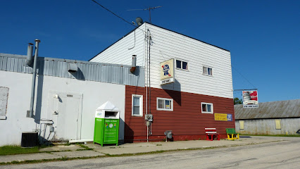
| Description | : | This cemetery is the remnants of the original "Saint Paul's Evangelical Reformed Church and Cemetery". (1913 - 1938). The church was closed and the parish merged with the 'Friedens Church' of Reedsville and they took over the cemetery. The church building and the chimney still stand and used as a storage shed, but the steeple, alter and stained glass windows were torn down, removed and stored in the lumber yards loft. Eventually the lumber yard was bought by another party and the old wooden building torn down and... Read More |
frequently asked questions (FAQ):
-
Where is Old Friedens Church Cemetery?
Old Friedens Church Cemetery is located at Main Street Collins, Manitowoc County ,Wisconsin , 54230USA.
-
Old Friedens Church Cemetery cemetery's updated grave count on graveviews.com?
0 memorials
-
Where are the coordinates of the Old Friedens Church Cemetery?
Latitude: 44.0875540
Longitude: -87.9846530
Nearby Cemetories:
1. Saint Peters Evangelical Lutheran Cemetery
Collins, Manitowoc County, USA
Coordinate: 44.0686000, -87.9927000
2. Streckert Cemetery
Collins, Manitowoc County, USA
Coordinate: 44.0572014, -88.0030975
3. Rockland EUB Cemetery
Reedsville, Manitowoc County, USA
Coordinate: 44.1383018, -87.9728012
4. J O Tyler Cemetery
Saint Nazianz, Manitowoc County, USA
Coordinate: 44.0372009, -87.9682999
5. Zion Evergreen Cemetery
Reedsville, Manitowoc County, USA
Coordinate: 44.1385994, -87.9428024
6. New Saint Marys Catholic Church Cemetery
Reedsville, Manitowoc County, USA
Coordinate: 44.1467018, -87.9644012
7. New Saint John-Saint James Lutheran Cemetery
Reedsville, Manitowoc County, USA
Coordinate: 44.1503000, -87.9634000
8. Old Saint John-Saint James Lutheran Cemetery
Reedsville, Manitowoc County, USA
Coordinate: 44.1515233, -87.9494782
9. Old Saint Marys Catholic Church Cemetery
Reedsville, Manitowoc County, USA
Coordinate: 44.1546211, -87.9610901
10. Rantoul EUB Cemetery
Potter, Calumet County, USA
Coordinate: 44.0806007, -88.0819016
11. Valders Cemetery
Valders, Manitowoc County, USA
Coordinate: 44.0511017, -87.9011002
12. Our Saviors Cemetery
Valders, Manitowoc County, USA
Coordinate: 44.0672140, -87.8836360
13. Friedens United Church of Christ Cemetery
Reedsville, Manitowoc County, USA
Coordinate: 44.1636009, -87.9582977
14. Free German Cemetery
Potter, Calumet County, USA
Coordinate: 44.1236000, -88.0849991
15. Trinity Lutheran Church Cemetery
Potter, Calumet County, USA
Coordinate: 44.1095900, -88.0934430
16. Grace Lutheran Cemetery
Cato, Manitowoc County, USA
Coordinate: 44.0716700, -87.8720200
17. Saint Marys Cemetery
Clarks Mills, Manitowoc County, USA
Coordinate: 44.0983009, -87.8647003
18. Old Clark Mills Cemetery
Cato, Manitowoc County, USA
Coordinate: 44.0923600, -87.8609400
19. Saint Gregory Cemetery
Saint Nazianz, Manitowoc County, USA
Coordinate: 44.0057000, -87.9283000
20. Salvatorian Cemetery
Saint Nazianz, Manitowoc County, USA
Coordinate: 43.9998100, -87.9283300
21. Trinity Lutheran Cemetery New
Brillion, Calumet County, USA
Coordinate: 44.1604100, -88.0738300
22. Brillion Community Cemetery
Brillion, Calumet County, USA
Coordinate: 44.1618880, -88.0737880
23. Trinity Lutheran Cemetery Old
Brillion, Calumet County, USA
Coordinate: 44.1641100, -88.0741100
24. Brillion Township Cemetery
Brillion, Calumet County, USA
Coordinate: 44.1642120, -88.0741630