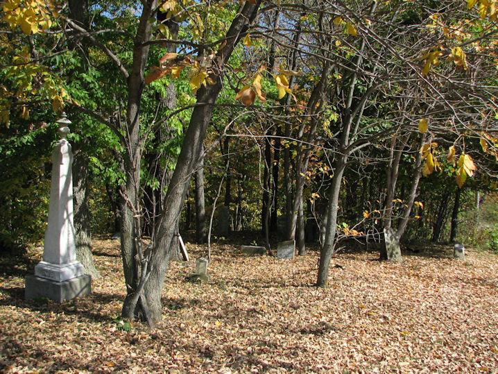
| Memorials | : | 0 |
| Location | : | Covington, Fountain County, USA |
| Coordinate | : | 40.1712960, -87.3802590 |
| Description | : | This cemetery is located northeast of Covington, Indiana. It is on the property that was once called the Ross DeHaven farm. The cemetery is located in Troy Township (SW quadrant of the SE quadrant of the SE quadrant of Section 13 Township 20N Range 9W) on the north side of Salem Church Road east of the house at 2484 Salem Church Road. Indiana Cemetery Locations, Volume 2, published by the Indiana Genealogical Society (01 April 2006), gives the primary cemetery name as Briney Cemetery. The cemetery is listed in the Cemetery and Burial Grounds Registry of... Read More |
frequently asked questions (FAQ):
-
Where is Briney Cemetery?
Briney Cemetery is located at 2484 – 2850 W. Salem Church Road Covington, Fountain County ,Indiana , 47932USA.
-
Briney Cemetery cemetery's updated grave count on graveviews.com?
0 memorials
-
Where are the coordinates of the Briney Cemetery?
Latitude: 40.1712960
Longitude: -87.3802590
Nearby Cemetories:
1. Danser Cemetery
Covington, Fountain County, USA
Coordinate: 40.1795520, -87.3796560
2. Poor Farm Cemetery
Fountain County, USA
Coordinate: 40.1817310, -87.3909850
3. Bend Cemetery
Covington, Fountain County, USA
Coordinate: 40.1783040, -87.4080740
4. Prescott Grove Cemetery
Covington, Fountain County, USA
Coordinate: 40.1497002, -87.3882980
5. Saint Joseph Catholic Cemetery
Covington, Fountain County, USA
Coordinate: 40.1495285, -87.3890533
6. Bilsland Cemetery
Troy Township, Fountain County, USA
Coordinate: 40.1630890, -87.4132090
7. Sand Hill Cemetery
Fountain County, USA
Coordinate: 40.1627998, -87.4194031
8. Ward Cemetery
Covington, Fountain County, USA
Coordinate: 40.1499405, -87.3503265
9. Oak Grove Cemetery
Covington, Fountain County, USA
Coordinate: 40.1374397, -87.3901520
10. Mount Hope Cemetery
Covington, Fountain County, USA
Coordinate: 40.1310997, -87.3850021
11. Lyons Cemetery
Warren County, USA
Coordinate: 40.2071400, -87.4097210
12. Woods Cemetery
Old Town, Warren County, USA
Coordinate: 40.2141100, -87.3877600
13. Upper Mound Cemetery
Warren County, USA
Coordinate: 40.1426480, -87.4231050
14. Dehaven Cemetery
Troy Township, Fountain County, USA
Coordinate: 40.1440460, -87.3283980
15. Rodgers Cemetery
Warren County, USA
Coordinate: 40.1662380, -87.4450990
16. Hendrix Cemetery
Fountain County, USA
Coordinate: 40.1258507, -87.3517227
17. Unidentified Cemetery
Troy Township, Fountain County, USA
Coordinate: 40.1258000, -87.3517000
18. Baltimore Cemetery
Warren County, USA
Coordinate: 40.1664009, -87.4460983
19. Bear Creek Cemetery
Fountain, Fountain County, USA
Coordinate: 40.2152100, -87.3334885
20. Pribble Cemetery
Attica, Fountain County, USA
Coordinate: 40.2197000, -87.3389000
21. Osborn Cemetery
Stone Bluff, Fountain County, USA
Coordinate: 40.1433010, -87.3117480
22. Cunningham Cemetery
Olin, Warren County, USA
Coordinate: 40.1313000, -87.4473000
23. Carnagey Cemetery
Troy Township, Fountain County, USA
Coordinate: 40.1208800, -87.3229080
24. Progressive Friends Church Cemetery
Stone Bluff, Fountain County, USA
Coordinate: 40.1786003, -87.2913971

