
| Memorials | : | 53 |
| Location | : | Carisbrooke, Isle of Wight Unitary Authority, England |
| Phone | : | 01983 523354 |
| Website | : | www.carisbrookepriory.org.uk |
| Coordinate | : | 50.6859710, -1.3070000 |
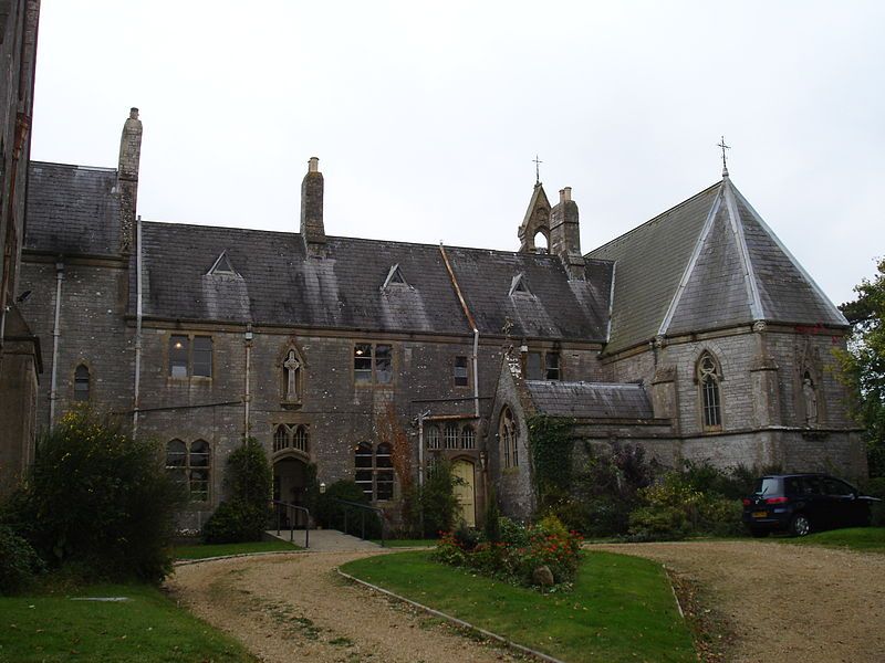
| Description | : | Carisbrooke Priory, originally the Priory of Our Lady of Reparation and St Dominic, was built in 1866 by Elizabeth, Dowager Countess of Clare, as a convent for the Second Order of St Dominic (Dominican Nuns). The Priory was designed by the celebrated English Catholic architect Gilbert Robert Blount (1819-1876), using local grey stone at a cost of £12,000. The Dominican Nuns occupied the premises until 1989. Carisbrooke Priory is now a house of prayer, offering tea rooms and gardens. The cemetery is located at the rear of the property and is open to the public. |
frequently asked questions (FAQ):
-
Where is Carisbrooke Priory?
Carisbrooke Priory is located at 39 Whitcombe Road Carisbrooke, Isle of Wight Unitary Authority ,Isle of Wight , PO30 1YSEngland.
-
Carisbrooke Priory cemetery's updated grave count on graveviews.com?
53 memorials
-
Where are the coordinates of the Carisbrooke Priory?
Latitude: 50.6859710
Longitude: -1.3070000
Nearby Cemetories:
1. Carisbrooke Cemetery
Carisbrooke, Isle of Wight Unitary Authority, England
Coordinate: 50.6882160, -1.3083040
2. St Thomas Church
Newport, Isle of Wight Unitary Authority, England
Coordinate: 50.6997610, -1.2940130
3. Newport Cemetery
Newport, Isle of Wight Unitary Authority, England
Coordinate: 50.7041360, -1.2887540
4. St Olave's Churchyard
Gatcombe, Isle of Wight Unitary Authority, England
Coordinate: 50.6636110, -1.3041670
5. Parkhurst Military Cemetery
Newport, Isle of Wight Unitary Authority, England
Coordinate: 50.7084440, -1.3044120
6. Isle of Wight Workhouse Burial Ground
Carisbrooke, Isle of Wight Unitary Authority, England
Coordinate: 50.7112150, -1.2979810
7. St Paul's Cemetery
Newport, Isle of Wight Unitary Authority, England
Coordinate: 50.7072300, -1.2827400
8. Parkhurst Prison Cemetery
Newport, Isle of Wight Unitary Authority, England
Coordinate: 50.7152100, -1.3082790
9. Isle of Wight Crematorium
Whippingham, Isle of Wight Unitary Authority, England
Coordinate: 50.7217910, -1.2573910
10. St John the Baptist Church
Northwood, Isle of Wight Unitary Authority, England
Coordinate: 50.7340380, -1.3023130
11. Calbourne Burial Ground
Calbourne, Isle of Wight Unitary Authority, England
Coordinate: 50.6832007, -1.3864018
12. Porchfield Congregational Cemetery
Porchfield, Isle of Wight Unitary Authority, England
Coordinate: 50.7190660, -1.3679770
13. St Peter's Parish Church
Shorwell, Isle of Wight Unitary Authority, England
Coordinate: 50.6449290, -1.3545580
14. Billingham Manor
Newport, Isle of Wight Unitary Authority, England
Coordinate: 50.6347663, -1.3140535
15. St Peter New Churchyard
Shorwell, Isle of Wight Unitary Authority, England
Coordinate: 50.6433100, -1.3541400
16. St. Mildred's Churchyard
Whippingham, Isle of Wight Unitary Authority, England
Coordinate: 50.7398230, -1.2768350
17. All Saints Churchyard
Calbourne, Isle of Wight Unitary Authority, England
Coordinate: 50.6772990, -1.3996370
18. All Saints Churchyard
Godshill, Isle of Wight Unitary Authority, England
Coordinate: 50.6336900, -1.2558300
19. St. Edmund's Churchyard
Wootton, Isle of Wight Unitary Authority, England
Coordinate: 50.7308220, -1.2344490
20. East Cowes Cemetery
East Cowes, Isle of Wight Unitary Authority, England
Coordinate: 50.7502300, -1.2876600
21. Northwood Cemetery
Cowes, Isle of Wight Unitary Authority, England
Coordinate: 50.7513700, -1.3003600
22. Holy Spirit Churchyard
Newtown, Isle of Wight Unitary Authority, England
Coordinate: 50.7143690, -1.4035400
23. St Peter's
Havenstreet, Isle of Wight Unitary Authority, England
Coordinate: 50.7095580, -1.2063290
24. St. Michael the Archangel Churchyard
Shalfleet, Isle of Wight Unitary Authority, England
Coordinate: 50.7014300, -1.4156370