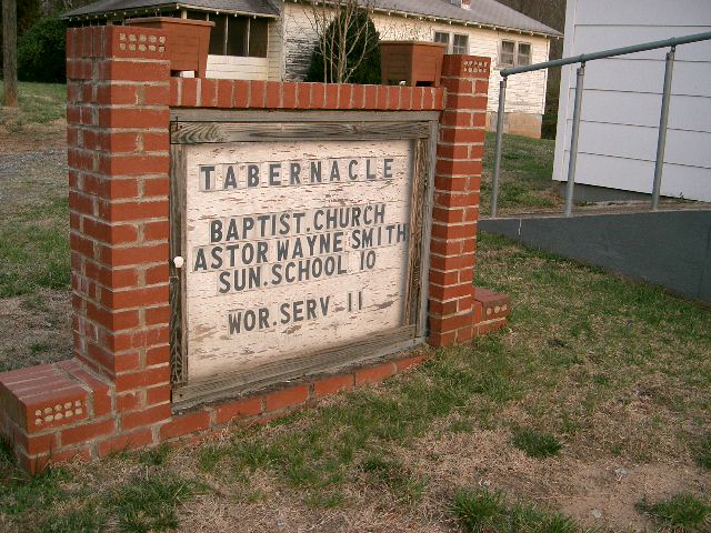
| Memorials | : | 0 |
| Location | : | Casar, Cleveland County, USA |
| Coordinate | : | 35.5172960, -81.6230690 |
| Description | : | Casar Tabernacle is located on Corinth Church Circle. It is on the left about 1/4 mile from the end. Corinth Church ROAD now has two ends (same road, I have no idea why). If you turn off Hwy 10 at the post office onto Casar Methodist Church Road then Corinth Church CIRCLE is not far on the left. Directions by; J. Gretchen Lowman |
frequently asked questions (FAQ):
-
Where is Casar Tabernacle Baptist Cemetery?
Casar Tabernacle Baptist Cemetery is located at Casar, Cleveland County ,North Carolina ,USA.
-
Casar Tabernacle Baptist Cemetery cemetery's updated grave count on graveviews.com?
0 memorials
-
Where are the coordinates of the Casar Tabernacle Baptist Cemetery?
Latitude: 35.5172960
Longitude: -81.6230690
Nearby Cemetories:
1. Casar United Methodist Church Cemetery
Casar, Cleveland County, USA
Coordinate: 35.5152600, -81.6183200
2. Hoyle Family Cemetery
Casar, Cleveland County, USA
Coordinate: 35.5139540, -81.6380520
3. Canaan Baptist Cemetery
Casar, Cleveland County, USA
Coordinate: 35.5228090, -81.6060110
4. Casar Baptist Cemetery
Casar, Cleveland County, USA
Coordinate: 35.5067450, -81.6099510
5. Zoar Baptist Church Cemetery
Casar, Cleveland County, USA
Coordinate: 35.5169296, -81.6045532
6. Corinth Baptist Church Cemetery
Casar, Cleveland County, USA
Coordinate: 35.5284615, -81.6434326
7. Old Cloverhill Cemetery
Casar, Cleveland County, USA
Coordinate: 35.4826190, -81.6239550
8. Clover Hill United Methodist Church Cemetery
Lawndale, Cleveland County, USA
Coordinate: 35.4817500, -81.6246000
9. New Home United Methodist Church Cemetery
Casar, Cleveland County, USA
Coordinate: 35.5064300, -81.6653100
10. Saint Paul Baptist Church Cemetery
Casar, Cleveland County, USA
Coordinate: 35.5082100, -81.5743600
11. Olive Grove Baptist Church Cemetery
Casar, Cleveland County, USA
Coordinate: 35.5456070, -81.5826490
12. Mount Zion Baptist Church Cemetery
Casar, Cleveland County, USA
Coordinate: 35.4843300, -81.6655900
13. Big Hill Graveyard
Lawndale, Cleveland County, USA
Coordinate: 35.5313880, -81.5622740
14. Pleasant Hill United Methodist Cemetery
Belwood, Cleveland County, USA
Coordinate: 35.4946830, -81.5641520
15. Buff Cemetery
Casar, Cleveland County, USA
Coordinate: 35.5504630, -81.5702350
16. Warlick Cemetery
Belwood, Cleveland County, USA
Coordinate: 35.4782982, -81.5639038
17. Calvary's Cross Baptist Cemetery
Lawndale, Cleveland County, USA
Coordinate: 35.4743690, -81.6791790
18. Willis Cemetery
Belwood, Cleveland County, USA
Coordinate: 35.4850000, -81.5566667
19. Carpenters Grove Baptist Church Cemetery
Lawndale, Cleveland County, USA
Coordinate: 35.5249786, -81.5454330
20. Procter Cemetery
Belwood, Cleveland County, USA
Coordinate: 35.4783330, -81.5600000
21. Pine Grove Primitive Baptist Church Cemetery
Lawndale, Cleveland County, USA
Coordinate: 35.4731483, -81.5638275
22. Lees Chapel United Methodist Church Cemetery
Polkville, Cleveland County, USA
Coordinate: 35.4860764, -81.6936951
23. House of Prayer Cemetery Fallston
Lawndale, Cleveland County, USA
Coordinate: 35.5383453, -81.5468903
24. Eaker Cemetery
Cleveland County, USA
Coordinate: 35.4516983, -81.6144028

