
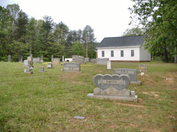
| Memorials | : | 10 |
| Location | : | Polkville, Cleveland County, USA |
| Coordinate | : | 35.4860764, -81.6936951 |
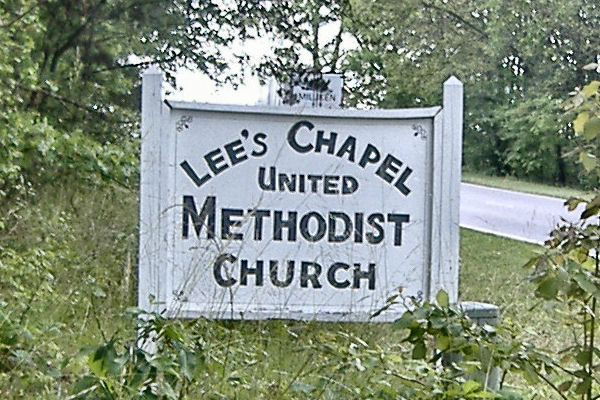
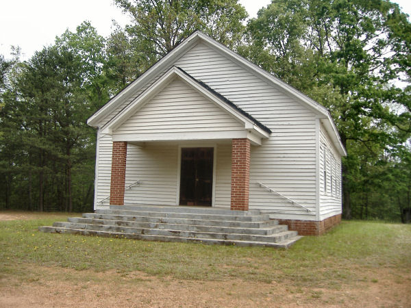
| Description | : | Lee's Chapel is located just off 226, on Lee's Chapel Road, just before you get to Rutherford County. The church and cemetery can be seen off of 226 in a clearing in the woods. The Church is very old and doesn't appear to be in use, yet the grounds and church itself are in excellent condition |
frequently asked questions (FAQ):
-
Where is Lees Chapel United Methodist Church Cemetery?
Lees Chapel United Methodist Church Cemetery is located at Polkville, Cleveland County ,North Carolina ,USA.
-
Lees Chapel United Methodist Church Cemetery cemetery's updated grave count on graveviews.com?
9 memorials
-
Where are the coordinates of the Lees Chapel United Methodist Church Cemetery?
Latitude: 35.4860764
Longitude: -81.6936951
Nearby Cemetories:
1. Calvary's Cross Baptist Cemetery
Lawndale, Cleveland County, USA
Coordinate: 35.4743690, -81.6791790
2. Mount Zion Baptist Church Cemetery
Casar, Cleveland County, USA
Coordinate: 35.4843300, -81.6655900
3. Mount Harmony Memorial Cemetery
Polkville, Cleveland County, USA
Coordinate: 35.4598700, -81.6858000
4. Diviney Cemetery
Duncans Creek, Rutherford County, USA
Coordinate: 35.5143920, -81.7042200
5. Duncans Creek Presbyterian Church Cemetery
Hollis, Rutherford County, USA
Coordinate: 35.4742680, -81.7276620
6. New Home United Methodist Church Cemetery
Casar, Cleveland County, USA
Coordinate: 35.5064300, -81.6653100
7. Price Family Cemetery
Hollis, Rutherford County, USA
Coordinate: 35.4548240, -81.7194440
8. Brooks Chapel United Methodist Church Cemetery
Shelby, Cleveland County, USA
Coordinate: 35.4461580, -81.6905520
9. Ferrells Chapel Cemetery
Shelby, Cleveland County, USA
Coordinate: 35.4520000, -81.6660000
10. Lattimore Family Cemetery
Polkville, Cleveland County, USA
Coordinate: 35.4472810, -81.6658400
11. Lattimore Baptist Cemetery
Lattimore, Cleveland County, USA
Coordinate: 35.4435997, -81.6667023
12. Big Springs Baptist Cemetery
Hollis, Rutherford County, USA
Coordinate: 35.4366430, -81.7119510
13. Hoyle Family Cemetery
Casar, Cleveland County, USA
Coordinate: 35.5139540, -81.6380520
14. Clover Hill United Methodist Church Cemetery
Lawndale, Cleveland County, USA
Coordinate: 35.4817500, -81.6246000
15. Old Cloverhill Cemetery
Casar, Cleveland County, USA
Coordinate: 35.4826190, -81.6239550
16. First Broad Baptist Church Cemetery
Bostic, Rutherford County, USA
Coordinate: 35.5176770, -81.7543960
17. Corinth Baptist Church Cemetery
Casar, Cleveland County, USA
Coordinate: 35.5284615, -81.6434326
18. Golden Valley Missionary Methodist Church Cemetery
Bostic, Rutherford County, USA
Coordinate: 35.4961700, -81.7678800
19. Fortune Cemetery
Rutherford County, USA
Coordinate: 35.5092010, -81.7647018
20. Elliott Cemetery
Polkville, Cleveland County, USA
Coordinate: 35.4247017, -81.6781006
21. Mount Pleasant Baptist Church Cemetery
Rutherford County, USA
Coordinate: 35.5509280, -81.6976340
22. Casar Tabernacle Baptist Cemetery
Casar, Cleveland County, USA
Coordinate: 35.5172960, -81.6230690
23. Casar United Methodist Church Cemetery
Casar, Cleveland County, USA
Coordinate: 35.5152600, -81.6183200
24. Casar Baptist Cemetery
Casar, Cleveland County, USA
Coordinate: 35.5067450, -81.6099510