
| Memorials | : | 0 |
| Location | : | Kingston, Madison County, USA |
| Coordinate | : | 36.0490300, -93.5159200 |
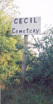
| Description | : | Cecil Cemetery is a small cemetery located just a short distance from the town square in Kingston, Arknasas. Take Highway 21 East at the Kingston Square and go about 1/10 of a mile; turn right on County Road #3609 and the cemetery will be on the left just about 200 feet from the highway. Cecil Cemetery began as a family cemetery in the 1870's and had only 9 graves until recently. In September 1, 2011, paperwork was filed with the State of Arkansas, so that this cemetery is now registered. According to these documents the legal name is now "Weaver Cemetery"... Read More |
frequently asked questions (FAQ):
-
Where is Cecil Cemetery?
Cecil Cemetery is located at Kingston, Madison County ,Arkansas ,USA.
-
Cecil Cemetery cemetery's updated grave count on graveviews.com?
0 memorials
-
Where are the coordinates of the Cecil Cemetery?
Latitude: 36.0490300
Longitude: -93.5159200
Nearby Cemetories:
1. Murrell Cemetery
Kingston, Madison County, USA
Coordinate: 36.0520700, -93.5156700
2. Kingston Cemetery
Kingston, Madison County, USA
Coordinate: 36.0416985, -93.5194016
3. Upper Campground Cemetery
Kingston, Madison County, USA
Coordinate: 36.0586014, -93.5447006
4. Silver Ridge Cemetery
Kingston, Madison County, USA
Coordinate: 36.0326700, -93.5400500
5. Page-David Page Grave
Kingston, Madison County, USA
Coordinate: 36.0235200, -93.4798800
6. Ribbon Ridge Graves
Madison County, USA
Coordinate: 36.0326700, -93.5683100
7. Lane Cemetery
Loy, Madison County, USA
Coordinate: 36.0093994, -93.5599976
8. Mount Olive Cemetery
Kingston, Madison County, USA
Coordinate: 35.9942017, -93.5100021
9. Phillips - R. M. Phillips Grave
Purdy, Madison County, USA
Coordinate: 36.0707700, -93.5890400
10. Spangler - Ford Cemetery
Wharton, Madison County, USA
Coordinate: 36.0457610, -93.5946150
11. Steele Cemetery
Wharton, Madison County, USA
Coordinate: 36.0249580, -93.5953700
12. Riley Cemetery
Marble, Madison County, USA
Coordinate: 36.1128100, -93.5616800
13. Burk Cemetery
Madison County, USA
Coordinate: 35.9712600, -93.5151500
14. Bolinger Cemetery
Madison County, USA
Coordinate: 35.9720000, -93.5409400
15. Liberty Cemetery
Dinsmore, Newton County, USA
Coordinate: 36.1226000, -93.4735000
16. Lower Campground Cemetery
Kingston, Madison County, USA
Coordinate: 36.1258200, -93.5529900
17. Big Sandy Cemetery
Purdy, Madison County, USA
Coordinate: 36.0939100, -93.6090700
18. Taylor Graves
Madison County, USA
Coordinate: 36.0016100, -93.6109100
19. Parker Family Cemetery
Wharton Township, Madison County, USA
Coordinate: 36.0221170, -93.6227930
20. Hopewell Cemetery
George, Newton County, USA
Coordinate: 36.0793991, -93.4085999
21. Wall Cemetery
Marble, Madison County, USA
Coordinate: 36.1301000, -93.5767300
22. Hargis-Davis Cemetery
Madison County, USA
Coordinate: 36.1146500, -93.6033900
23. Crossroads Cemetery
Stoverville, Newton County, USA
Coordinate: 36.0321900, -93.3983810
24. Mead-Burney-Gibbs Cemetery
Purdy, Madison County, USA
Coordinate: 36.0702900, -93.6430100