
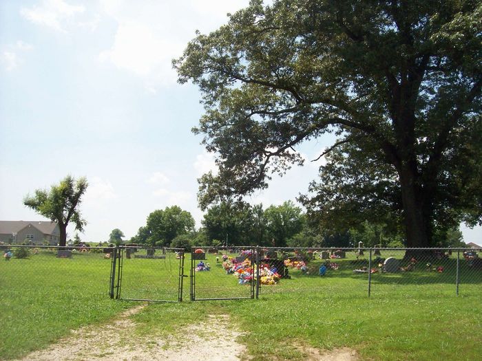
| Memorials | : | 12 |
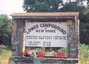
| Location | : | Kingston, Madison County, USA |
| Coordinate | : | 36.1258200, -93.5529900 |
| Description | : | From Huntsville, go East on Arkansas State Highway #412 for 10 miles; turn right (south) on State Highway #21. Go 1/2 mile on Highway #21 and turn right on Madison County Road #2120. The cemetery is located about 1/10 mile off of the highway in the NE ¼ of the NE ¼ NE ¼, Section 20, Township 17 North, Range 24 West. Decoration Day is annually on the Sunday before the 30th of May. |
frequently asked questions (FAQ):
-
Where is Lower Campground Cemetery?
Lower Campground Cemetery is located at Kingston, Madison County ,Arkansas ,USA.
-
Lower Campground Cemetery cemetery's updated grave count on graveviews.com?
12 memorials
-
Where are the coordinates of the Lower Campground Cemetery?
Latitude: 36.1258200
Longitude: -93.5529900
Nearby Cemetories:
1. Riley Cemetery
Marble, Madison County, USA
Coordinate: 36.1128100, -93.5616800
2. Wall Cemetery
Marble, Madison County, USA
Coordinate: 36.1301000, -93.5767300
3. Hargis-Davis Cemetery
Madison County, USA
Coordinate: 36.1146500, -93.6033900
4. Taylor Family Cemetery
Marble, Madison County, USA
Coordinate: 36.1278400, -93.6101500
5. Big Sandy Cemetery
Purdy, Madison County, USA
Coordinate: 36.0939100, -93.6090700
6. Sugg Cemetery
Dryfork, Carroll County, USA
Coordinate: 36.1529660, -93.4893830
7. Merrill Cemetery
Madison County, USA
Coordinate: 36.1773700, -93.5947100
8. Phillips - R. M. Phillips Grave
Purdy, Madison County, USA
Coordinate: 36.0707700, -93.5890400
9. Liberty Cemetery
Dinsmore, Newton County, USA
Coordinate: 36.1226000, -93.4735000
10. Upper Campground Cemetery
Kingston, Madison County, USA
Coordinate: 36.0586014, -93.5447006
11. Dean Cemetery
Dean, Carroll County, USA
Coordinate: 36.1921860, -93.5335800
12. Murrell Cemetery
Kingston, Madison County, USA
Coordinate: 36.0520700, -93.5156700
13. Cecil Cemetery
Kingston, Madison County, USA
Coordinate: 36.0490300, -93.5159200
14. Spangler - Ford Cemetery
Wharton, Madison County, USA
Coordinate: 36.0457610, -93.5946150
15. Kingston Cemetery
Kingston, Madison County, USA
Coordinate: 36.0416985, -93.5194016
16. Cain-Fielding Cemetery
Alabam, Madison County, USA
Coordinate: 36.0993000, -93.6578000
17. Mead-Burney-Gibbs Cemetery
Purdy, Madison County, USA
Coordinate: 36.0702900, -93.6430100
18. Silver Ridge Cemetery
Kingston, Madison County, USA
Coordinate: 36.0326700, -93.5400500
19. Ribbon Ridge Graves
Madison County, USA
Coordinate: 36.0326700, -93.5683100
20. White Oak Cemetery
Metalton, Carroll County, USA
Coordinate: 36.2099991, -93.6156006
21. Gobbler Cemetery
Gobbler, Carroll County, USA
Coordinate: 36.1878480, -93.4584940
22. Alabam Cemetery
Alabam, Madison County, USA
Coordinate: 36.1347100, -93.6795700
23. Thurston Cemetery
Madison County, USA
Coordinate: 36.0932700, -93.6737900
24. Carlock Cemetery
Huntsville, Madison County, USA
Coordinate: 36.1067009, -93.6802979