
| Memorials | : | 0 |
| Location | : | Montgomery County, USA |
| Coordinate | : | 41.1452141, -95.2787018 |
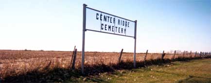
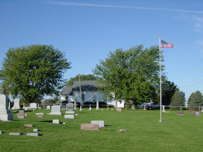
| Description | : | This cemetery sits next to a little country church called Center Ridge Presbyterian Church. The land for both the church and the cemetery were donated by adjacent farmers/land owners Simeon and Mary Jane Aiken in 1883. Their son J. Edward Aiken is the oldest burial of the approximately 190 burials there. His burial was in 1874. The two acres was donated to the Trustees of the church. In 1926 ownership and care of the cemetery was transferred to Lincoln Township. Lincoln Township still cares for the cemetery as of this writing in 2011. ... Read More |
frequently asked questions (FAQ):
-
Where is Center Ridge Cemetery?
Center Ridge Cemetery is located at Montgomery County ,Iowa ,USA.
-
Center Ridge Cemetery cemetery's updated grave count on graveviews.com?
0 memorials
-
Where are the coordinates of the Center Ridge Cemetery?
Latitude: 41.1452141
Longitude: -95.2787018

Nearby Cemetories:
1. Gomer Cemetery
Wales, Montgomery County, USA
Coordinate: 41.1171989, -95.3082962
2. Buckner Cemetery
Wales, Montgomery County, USA
Coordinate: 41.1595600, -95.3440700
3. L Laire Property Cemetery (Defunct)
Sherman Township, Montgomery County, USA
Coordinate: 41.0958257, -95.2224927
4. Mormon Cemetery
Macedonia, Pottawattamie County, USA
Coordinate: 41.1885986, -95.3557663
5. Waveland Cemetery
Pottawattamie County, USA
Coordinate: 41.1738700, -95.1881500
6. Bradway Farm Cemetery
Macedonia, Pottawattamie County, USA
Coordinate: 41.2083300, -95.3336500
7. Wheeler Grove Cemetery
Macedonia, Pottawattamie County, USA
Coordinate: 41.2131691, -95.3393631
8. Indian Graveyard
Sherman Township, Montgomery County, USA
Coordinate: 41.0955730, -95.1837580
9. Mercer Cemetery
Pottawattamie County, USA
Coordinate: 41.1753006, -95.1650009
10. Hillside Cemetery
Elliott, Montgomery County, USA
Coordinate: 41.1408005, -95.1544037
11. Saint Clair Cemetery
Red Oak Township, Montgomery County, USA
Coordinate: 41.0598400, -95.2049810
12. Farm Creek Cemetery
Henderson, Mills County, USA
Coordinate: 41.1319008, -95.4186020
13. Saint Marys Cemetery
Red Oak, Montgomery County, USA
Coordinate: 41.0447006, -95.2275009
14. Flint Cemetery
Pottawattamie County, USA
Coordinate: 41.2289009, -95.1841965
15. Macedonia Cemetery
Macedonia, Pottawattamie County, USA
Coordinate: 41.1921997, -95.4167023
16. Haefflick Burial Site
Red Oak, Montgomery County, USA
Coordinate: 41.0726300, -95.1561700
17. Lowens Cemetery
Garfield Township, Montgomery County, USA
Coordinate: 41.0527728, -95.3758292
18. Griswold Cemetery
Waveland Township, Pottawattamie County, USA
Coordinate: 41.2360992, -95.1735992
19. Pleasant Township Cemetery
Griswold, Cass County, USA
Coordinate: 41.2056000, -95.1370000
20. Evergreen Cemetery
Red Oak, Montgomery County, USA
Coordinate: 41.0228004, -95.2205963
21. Carson Cemetery
Carson, Pottawattamie County, USA
Coordinate: 41.2392006, -95.4044037
22. Old Town Cemetery
Macedonia, Pottawattamie County, USA
Coordinate: 41.2030983, -95.4421997
23. Pilot Grove Center Cemetery
Elliott, Montgomery County, USA
Coordinate: 41.1190600, -95.0993700
24. Lowman Cemetery
Griswold, Cass County, USA
Coordinate: 41.1594009, -95.0886002