
| Memorials | : | 1 |
| Location | : | Cloe, Jefferson County, USA |
| Coordinate | : | 40.9293210, -78.9359090 |
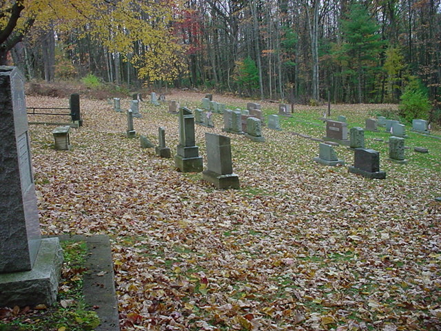
| Description | : | The Cherva Agudath Achuin Hebrew Cemetery is located next to the Oaklawn Cemetery in the Village of Cloe,Bell Township,Jefferson county,Pennsylvania. A brief history : Dated 27 February 1896 found in a Punxsutawney newspaper; A GRAND JEWISH BALL The Hebrew congregation of Punxsutawney,will give a grand ball in the Municipal Hall on Thursday February 27,for the purpose of raising funds to purchase a Jewish cemetery near this place.The celebrated Roscoe's Orchestra ,of DuBois,has been secured for the occasion,and no pains will be spared to make the affair a success.Everybody is invited.Tickets for sale at the Mammoth Shoe Store. Directions: Follow SR 36 south of Punxsutawney,turn right onto... Read More |
frequently asked questions (FAQ):
-
Where is Cherva Agudath Achuin Hebrew Cemetery?
Cherva Agudath Achuin Hebrew Cemetery is located at Cloe, Jefferson County ,Pennsylvania ,USA.
-
Cherva Agudath Achuin Hebrew Cemetery cemetery's updated grave count on graveviews.com?
1 memorials
-
Where are the coordinates of the Cherva Agudath Achuin Hebrew Cemetery?
Latitude: 40.9293210
Longitude: -78.9359090
Nearby Cemetories:
1. Oak Lawn Cemetery
Cloe, Jefferson County, USA
Coordinate: 40.9300003, -78.9356003
2. Circle Hill Cemetery
Punxsutawney, Jefferson County, USA
Coordinate: 40.9486008, -78.9496994
3. Pearce Cemetery
Rossiter, Indiana County, USA
Coordinate: 40.9028015, -78.9225006
4. Saint Peters Reformed Cemetery
Punxsutawney, Jefferson County, USA
Coordinate: 40.9515150, -78.9616910
5. North Findley Street Cemetery
Punxsutawney, Jefferson County, USA
Coordinate: 40.9466000, -78.9724000
6. Brooks Cemetery
Punxsutawney, Jefferson County, USA
Coordinate: 40.9247250, -78.8881340
7. Pleasant Grove Cemetery
Jefferson County, USA
Coordinate: 40.9398000, -78.8835000
8. Ridgemount Cemetery
Punxsutawney, Jefferson County, USA
Coordinate: 40.9719009, -78.9317017
9. Clayville Cemetery
Punxsutawney, Jefferson County, USA
Coordinate: 40.9470000, -78.9880000
10. Calvary Cemetery
Punxsutawney, Jefferson County, USA
Coordinate: 40.9358215, -78.9930725
11. Rhoades Cemetery
Big Run, Jefferson County, USA
Coordinate: 40.9318000, -78.8719000
12. Union Church Cemetery
Rossiter, Indiana County, USA
Coordinate: 40.8813490, -78.9239570
13. Old Cumberland Cemetery
Jefferson County, USA
Coordinate: 40.9264000, -78.8704000
14. Mount Zion Memorial Cemetery
Jefferson County, USA
Coordinate: 40.9794000, -78.9254000
15. Bowers Cemetery
Gaskill Township, Jefferson County, USA
Coordinate: 40.9472008, -78.8716965
16. Saints Peter and Paul Byzantine Cemetery
Punxsutawney, Jefferson County, USA
Coordinate: 40.9750000, -78.9706000
17. John R. Bazella Family Cemetery
Rossiter, Indiana County, USA
Coordinate: 40.8730260, -78.9336780
18. Horatio Cemetery
Punxsutawney, Jefferson County, USA
Coordinate: 40.9392000, -79.0133000
19. Devers Cemetery
Indiana County, USA
Coordinate: 40.8905000, -78.8751000
20. McClure Cemetery
Big Run, Jefferson County, USA
Coordinate: 40.9706100, -78.8750300
21. Saints Peter And Paul Byzantine Catholic Cemetery
Horatio, Jefferson County, USA
Coordinate: 40.9324989, -79.0180969
22. Sherman Farm Cemetery
Rossiter, Indiana County, USA
Coordinate: 40.8761410, -78.8890890
23. Fairview Cemetery
Big Run, Jefferson County, USA
Coordinate: 40.9740300, -78.8728300
24. Gray Cemetery
Big Run, Jefferson County, USA
Coordinate: 40.9729000, -78.8714500