
| Memorials | : | 1 |
| Location | : | Punxsutawney, Jefferson County, USA |
| Coordinate | : | 40.9392000, -79.0133000 |
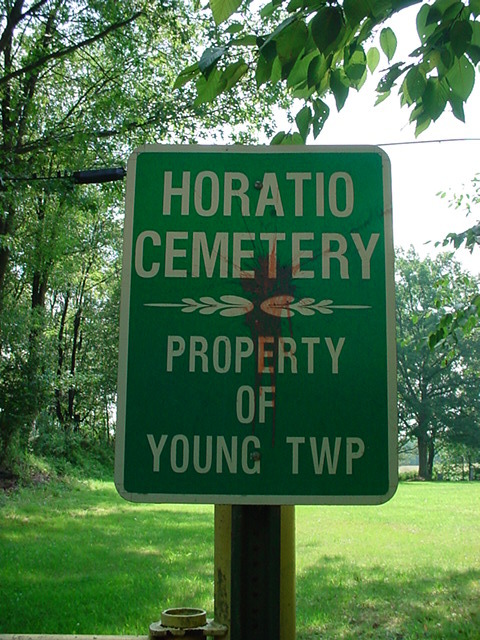
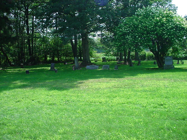
| Description | : | The Horatio Cemetery, also known as The Congregational Church Cemetery; is located in Young Township,Jefferson County,Pennsylvania; a short distance off of the No.8 Road (from Perry Street) on Diamond Road,west of the Boro of Punxsutawney. Founded on a tract of land originally containing about 74 acres and owned by Horatio Fisher,who later sold to Sophia Williams, who later sold the tract to the Punxsutawney Coal & Coke Company;that deed reserved a plot of land slightly more than 2 acres for the cemetery to the Horatio Cemetery Association. The Punxsutawney Coal & Coke Company later sold the entire tract of land... Read More |
frequently asked questions (FAQ):
-
Where is Horatio Cemetery?
Horatio Cemetery is located at Diamond Road Punxsutawney, Jefferson County ,Pennsylvania , 15767USA.
-
Horatio Cemetery cemetery's updated grave count on graveviews.com?
1 memorials
-
Where are the coordinates of the Horatio Cemetery?
Latitude: 40.9392000
Longitude: -79.0133000
Nearby Cemetories:
1. Saints Peter And Paul Byzantine Catholic Cemetery
Horatio, Jefferson County, USA
Coordinate: 40.9324989, -79.0180969
2. Calvary Cemetery
Punxsutawney, Jefferson County, USA
Coordinate: 40.9358215, -78.9930725
3. Clayville Cemetery
Punxsutawney, Jefferson County, USA
Coordinate: 40.9470000, -78.9880000
4. Hopewell United Methodist Church Cemetery
Frostburg, Jefferson County, USA
Coordinate: 40.9620000, -79.0393000
5. North Findley Street Cemetery
Punxsutawney, Jefferson County, USA
Coordinate: 40.9466000, -78.9724000
6. Valier Cemetery
Valier, Jefferson County, USA
Coordinate: 40.9210000, -79.0490000
7. Saint Peters Reformed Cemetery
Punxsutawney, Jefferson County, USA
Coordinate: 40.9515150, -78.9616910
8. Perry Memorial Cemetery
Frostburg, Jefferson County, USA
Coordinate: 40.9599991, -79.0635986
9. Saints Peter and Paul Byzantine Cemetery
Punxsutawney, Jefferson County, USA
Coordinate: 40.9750000, -78.9706000
10. Circle Hill Cemetery
Punxsutawney, Jefferson County, USA
Coordinate: 40.9486008, -78.9496994
11. Little Zion Cemetery
Covode, Indiana County, USA
Coordinate: 40.8885720, -79.0111350
12. White Church Cemetery
Hamilton, Jefferson County, USA
Coordinate: 40.9150650, -79.0783690
13. Mount Pleasant Cemetery of Covode
Covode, Indiana County, USA
Coordinate: 40.8838640, -79.0164720
14. Olive Cemetery
Oliveburg, Jefferson County, USA
Coordinate: 40.9940000, -79.0270000
15. Cherva Agudath Achuin Hebrew Cemetery
Cloe, Jefferson County, USA
Coordinate: 40.9293210, -78.9359090
16. Oak Lawn Cemetery
Cloe, Jefferson County, USA
Coordinate: 40.9300003, -78.9356003
17. Anita Community Cemetery
Anita, Jefferson County, USA
Coordinate: 40.9932450, -78.9790390
18. Methodist Episcopal Cemetery
Covode, Indiana County, USA
Coordinate: 40.8779000, -79.0165000
19. Grange Church of God Cemetery
Grange, Jefferson County, USA
Coordinate: 40.9647170, -79.0876330
20. Adrian-Anita Roman Catholic Cemetery
Anita, Jefferson County, USA
Coordinate: 40.9958000, -78.9805984
21. Anita Cemetery
Anita, Jefferson County, USA
Coordinate: 40.9972500, -78.9770700
22. Saint Jacob Cemetery
Jefferson County, USA
Coordinate: 40.9461900, -79.0987400
23. Mount Tabor United Methodist Church Cemetery
Battle Hollow, Jefferson County, USA
Coordinate: 41.0030000, -78.9970000
24. Ridgemount Cemetery
Punxsutawney, Jefferson County, USA
Coordinate: 40.9719009, -78.9317017