
| Memorials | : | 264 |
| Location | : | Accrington, Hyndburn Borough, England |
| Coordinate | : | 53.7478560, -2.3605820 |
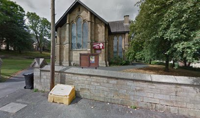
| Description | : | Originally Christ Church but now known as Trinity Community Church. The LEP formed in 2008 by the coming together of Christ Church, Cannon Street Baptist Church and Woodnook Baptist Church. All stones from the Churchyard have been removed which is now partly cover by a playground. The last burial took place in 1966. There is no indication or record that the remains were re-interred elsewhere. |
frequently asked questions (FAQ):
-
Where is Christ Church Churchyard?
Christ Church Churchyard is located at Rough Lee Road, Accrington, Hyndburn Borough, Lancashire, England Accrington, Hyndburn Borough ,Lancashire ,England.
-
Christ Church Churchyard cemetery's updated grave count on graveviews.com?
261 memorials
-
Where are the coordinates of the Christ Church Churchyard?
Latitude: 53.7478560
Longitude: -2.3605820
Nearby Cemetories:
1. St. James' Parish Church
Accrington, Hyndburn Borough, England
Coordinate: 53.7519900, -2.3652600
2. St. John the Baptist Churchyard
Baxenden, Hyndburn Borough, England
Coordinate: 53.7346500, -2.3470230
3. Accrington Cemetery and Crematorium
Accrington, Hyndburn Borough, England
Coordinate: 53.7623787, -2.3508649
4. Church and Clayton-le-Moors Cemetery
Accrington, Hyndburn Borough, England
Coordinate: 53.7630200, -2.3804820
5. St James Churchyard
Church, Hyndburn Borough, England
Coordinate: 53.7574640, -2.3942660
6. New Lane Baptist Chapel Chapelyard
Oswaldwistle, Hyndburn Borough, England
Coordinate: 53.7381100, -2.4049500
7. Immanuel Churchyard
Oswaldwistle, Hyndburn Borough, England
Coordinate: 53.7358300, -2.4056200
8. Barnes Square Weslyan Methodist Churchyard
Clayton-le-Moors, Hyndburn Borough, England
Coordinate: 53.7744350, -2.3853800
9. All Saints Churchyard
Clayton-le-Moors, Hyndburn Borough, England
Coordinate: 53.7738520, -2.3881690
10. St Marys Burial Ground
Clayton-le-Moors, Hyndburn Borough, England
Coordinate: 53.7792778, -2.3705871
11. St Margaret Churchyard
Hapton, Burnley Borough, England
Coordinate: 53.7802400, -2.3169230
12. Rehoboth Chapel
Goodshaw, Rossendale Borough, England
Coordinate: 53.7355870, -2.2914730
13. Great Harwood Cemetery
Great Harwood, Hyndburn Borough, England
Coordinate: 53.7796190, -2.4091680
14. Our Lady and Saint Hubert
Great Harwood, Hyndburn Borough, England
Coordinate: 53.7851070, -2.4009760
15. St James Churchyard
Haslingden, Rossendale Borough, England
Coordinate: 53.7084000, -2.3259550
16. St James Church
Altham, Hyndburn Borough, England
Coordinate: 53.7928940, -2.3465250
17. Providence Free United Methodist Graveyard
Crawshawbooth, Rossendale Borough, England
Coordinate: 53.7442070, -2.2825700
18. King Street Methodist Chapel Chapelyard
Haslingden, Rossendale Borough, England
Coordinate: 53.7066710, -2.3231330
19. Haslingden Grane Methodist Chapel Cemetery
Haslingden, Rossendale Borough, England
Coordinate: 53.7016300, -2.3728190
20. Ebenezer Baptist Chapel Chapelyard
Haslingden, Rossendale Borough, England
Coordinate: 53.7053960, -2.3230070
21. St. Mary and All Saints Churchyard
Goodshaw, Rossendale Borough, England
Coordinate: 53.7315270, -2.2828940
22. Crawshawbooth Quaker Burial Ground
Crawshawbooth, Rossendale Borough, England
Coordinate: 53.7242420, -2.2879400
23. Goodshaw Particular Baptist Chapel Graveyard
Goodshaw, Rossendale Borough, England
Coordinate: 53.7328210, -2.2815530
24. St. Bartholomew's Churchyard
Great Harwood, Hyndburn Borough, England
Coordinate: 53.7900670, -2.4055460