
| Memorials | : | 0 |
| Location | : | Melton Ross, North Lincolnshire Unitary Authority, England |
| Coordinate | : | 53.5824000, -0.3830000 |
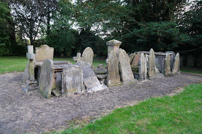
| Description | : | The Church of the Holy Ascension is a Grade II Listed Building. Designed by Ewan Christian, built c.1867. Replacing an earlier church on the site. Unfortuantely, like a lot of Church burial grounds in the Lincoln Diocese the majority of the headstones have been removed to the sides or a single site in the burial ground. I can not confirm wether any have been used as paving slabs, removed or sold. |
frequently asked questions (FAQ):
-
Where is Church of the Holy Ascension Burial Ground?
Church of the Holy Ascension Burial Ground is located at Middlegate Lane, Melton Mowbray, near Brigg Melton Ross, North Lincolnshire Unitary Authority ,Lincolnshire , DN38 6DREngland.
-
Church of the Holy Ascension Burial Ground cemetery's updated grave count on graveviews.com?
0 memorials
-
Where are the coordinates of the Church of the Holy Ascension Burial Ground?
Latitude: 53.5824000
Longitude: -0.3830000
Nearby Cemetories:
1. St. Mary's Churchyard
Barnetby le Wold, North Lincolnshire Unitary Authority, England
Coordinate: 53.5782540, -0.4088070
2. St John's Church
Croxton, North Lincolnshire Unitary Authority, England
Coordinate: 53.5955990, -0.3477220
3. All Saints Parish Church
Bigby, West Lindsey District, England
Coordinate: 53.5531600, -0.4019100
4. St Helen's
Kirmington, North Lincolnshire Unitary Authority, England
Coordinate: 53.5866210, -0.3306200
5. All Saints Church
Elsham, North Lincolnshire Unitary Authority, England
Coordinate: 53.5992620, -0.4355590
6. St Margaret Churchyard
Somerby, West Lindsey District, England
Coordinate: 53.5455030, -0.3982090
7. Elwes Private Cemetery, Elsham Hall
Elsham, North Lincolnshire Unitary Authority, England
Coordinate: 53.5932154, -0.4451006
8. St Nicholas Churchyard
Searby, West Lindsey District, England
Coordinate: 53.5384960, -0.3830950
9. St Nicholas Churchyard
Ulceby, North Lincolnshire Unitary Authority, England
Coordinate: 53.6163770, -0.3334470
10. Saint Mary's Church
Wrawby, North Lincolnshire Unitary Authority, England
Coordinate: 53.5642110, -0.4609630
11. St Andrew's Churchyard
Wootton, North Lincolnshire Unitary Authority, England
Coordinate: 53.6306857, -0.3549418
12. All Saints Churchyard
Grasby, West Lindsey District, England
Coordinate: 53.5295671, -0.3610532
13. Grasby Church Burial Ground
Grasby, West Lindsey District, England
Coordinate: 53.5285230, -0.3598880
14. St. Clement's Churchyard
Worlaby, North Lincolnshire Unitary Authority, England
Coordinate: 53.6129220, -0.4667760
15. St Peter
Great Limber, West Lindsey District, England
Coordinate: 53.5619890, -0.2879080
16. Saint Peter's churchyard
Great Limber, West Lindsey District, England
Coordinate: 53.5620200, -0.2878700
17. All Saints Churchyard
Brocklesby, West Lindsey District, England
Coordinate: 53.5860350, -0.2798300
18. Brigg Cemetery
Brigg, North Lincolnshire Unitary Authority, England
Coordinate: 53.5559600, -0.4817300
19. All Hallows Churchyard
Clixby, West Lindsey District, England
Coordinate: 53.5233610, -0.3384560
20. St John the Evangelist Churchyard
Brigg, North Lincolnshire Unitary Authority, England
Coordinate: 53.5518740, -0.4913750
21. St Andrew Churchyard
Bonby, North Lincolnshire Unitary Authority, England
Coordinate: 53.6266000, -0.4838000
22. St Margaret Churchyard
Habrough, North East Lincolnshire Unitary Authority, England
Coordinate: 53.6126080, -0.2555870
23. All Saints Churchyard
Cadney, North Lincolnshire Unitary Authority, England
Coordinate: 53.5175500, -0.4671070
24. North Kelsey Cemetery
North Kelsey, West Lindsey District, England
Coordinate: 53.5043330, -0.4245830