
| Memorials | : | 279 |
| Location | : | Bonby, North Lincolnshire Unitary Authority, England |
| Coordinate | : | 53.6266000, -0.4838000 |
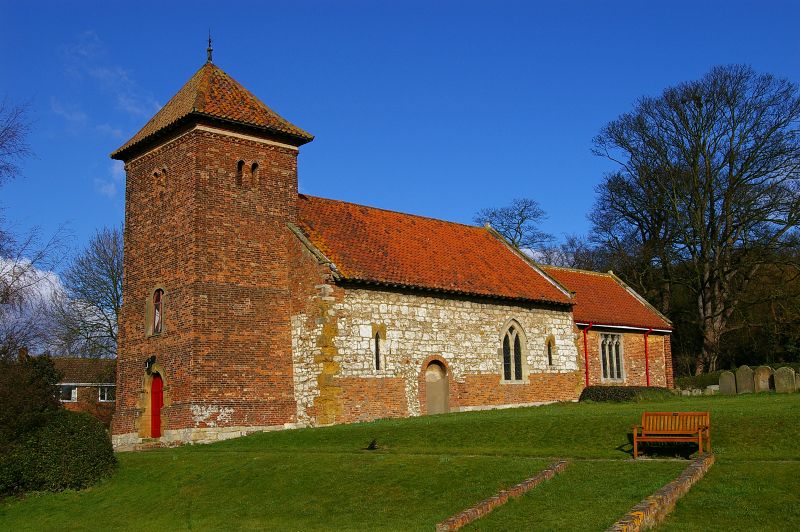
| Description | : | In the entry for Bonby in the Domesday Book of 1086 there is no mention of a church or religious institution. However sometime in the 1100s a small religious cell was established belonging to the Priory of St. Fromond in Normandy. Its existence was confirmed by Pope Alexander III on the 8th March 1179 during the reign of Henry II. Early in the 1900s a boiler house was built next to the vestry for a central heating system, coke fired. In the late 1940s electricity was installed and a few years later mains water was piped to the building. Recently in the tower,... Read More |
frequently asked questions (FAQ):
-
Where is St Andrew Churchyard?
St Andrew Churchyard is located at Bonby, North Lincolnshire Unitary Authority, England.
-
St Andrew Churchyard cemetery's updated grave count on graveviews.com?
279 memorials
-
Where are the coordinates of the St Andrew Churchyard?
Latitude: 53.6266000
Longitude: -0.4838000
Nearby Cemetories:
1. All Saints' Churchyard
Saxby-All-Saints, North Lincolnshire Unitary Authority, England
Coordinate: 53.6372500, -0.5010260
2. St. Clement's Churchyard
Worlaby, North Lincolnshire Unitary Authority, England
Coordinate: 53.6129220, -0.4667760
3. St Maurice Churchyard
Horkstow, North Lincolnshire Unitary Authority, England
Coordinate: 53.6512040, -0.5079660
4. All Saints Church
Elsham, North Lincolnshire Unitary Authority, England
Coordinate: 53.5992620, -0.4355590
5. Elwes Private Cemetery, Elsham Hall
Elsham, North Lincolnshire Unitary Authority, England
Coordinate: 53.5932154, -0.4451006
6. St Bartholomew's Church
Appleby, North Lincolnshire Unitary Authority, England
Coordinate: 53.6234280, -0.5603240
7. St Nicholas Churchyard
South Ferriby, North Lincolnshire Unitary Authority, England
Coordinate: 53.6746420, -0.5051450
8. Saint Mary's Church
Wrawby, North Lincolnshire Unitary Authority, England
Coordinate: 53.5642110, -0.4609630
9. St Mary's Churchyard
Barton-upon-Humber, North Lincolnshire Unitary Authority, England
Coordinate: 53.6844300, -0.4367800
10. Barton-upon-Humber Old Cemetery
Barton-upon-Humber, North Lincolnshire Unitary Authority, England
Coordinate: 53.6818650, -0.4284450
11. Barton-Upon-Humber Cemetery
Barton-upon-Humber, North Lincolnshire Unitary Authority, England
Coordinate: 53.6817370, -0.4279560
12. St. Mary's Churchyard
Barnetby le Wold, North Lincolnshire Unitary Authority, England
Coordinate: 53.5782540, -0.4088070
13. Winterton Cemetery
Winterton, North Lincolnshire Unitary Authority, England
Coordinate: 53.6548190, -0.5847270
14. Broughton Cemetery
Broughton, North Lincolnshire Unitary Authority, England
Coordinate: 53.5732500, -0.5582900
15. Brigg Cemetery
Brigg, North Lincolnshire Unitary Authority, England
Coordinate: 53.5559600, -0.4817300
16. All Saints Churchyard
Winterton, North Lincolnshire Unitary Authority, England
Coordinate: 53.6555710, -0.5968640
17. St Marys Churchyard
Broughton, North Lincolnshire Unitary Authority, England
Coordinate: 53.5654330, -0.5514190
18. Broughton Church Cemetery
Broughton, North Lincolnshire Unitary Authority, England
Coordinate: 53.5649200, -0.5504110
19. Church of the Holy Ascension Burial Ground
Melton Ross, North Lincolnshire Unitary Authority, England
Coordinate: 53.5824000, -0.3830000
20. St John the Evangelist Churchyard
Brigg, North Lincolnshire Unitary Authority, England
Coordinate: 53.5518740, -0.4913750
21. Barrow-Upon-Humber Cemetery
Barrow upon Humber, North Lincolnshire Unitary Authority, England
Coordinate: 53.6678740, -0.3755040
22. St Andrew's Churchyard
Wootton, North Lincolnshire Unitary Authority, England
Coordinate: 53.6306857, -0.3549418
23. Holy Trinity Churchyard
Barrow upon Humber, North Lincolnshire Unitary Authority, England
Coordinate: 53.6783720, -0.3787880
24. St John's Church
Croxton, North Lincolnshire Unitary Authority, England
Coordinate: 53.5955990, -0.3477220