| Memorials | : | 587 |
| Location | : | La Patera, Santa Barbara County, USA |
| Coordinate | : | 34.4402920, -119.7744090 |
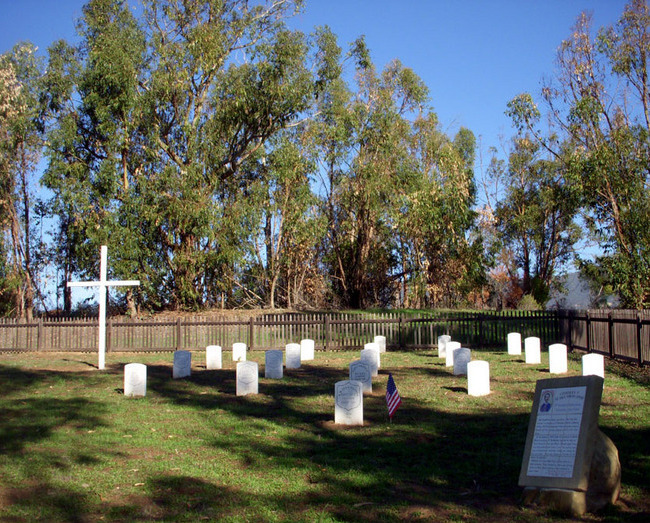
| Description | : | Also referred to as La Patera or Old Catholic Cemetery, from 1873 until January 1897 over 1,200 people were buried here. The Catholic Church took possession on 19 November 1875 when Thomas Hope, for whom Hope Ranch is named, transferred the six-acre property to the church for a dollar. A few burials took place before the deed of transfer. Some remains interred at Cieneguitas were later re-interred at Calvary Catholic Cemetery, which opened on Hope Avenue in 1896. Because of the research of local Santa Barbara historian Neal Graffy and the late Ed Strobridge of the Order of Minor... Read More |
frequently asked questions (FAQ):
-
Where is Cieneguitas Catholic Cemetery?
Cieneguitas Catholic Cemetery is located at La Patera, Santa Barbara County ,California ,USA.
-
Cieneguitas Catholic Cemetery cemetery's updated grave count on graveviews.com?
587 memorials
-
Where are the coordinates of the Cieneguitas Catholic Cemetery?
Latitude: 34.4402920
Longitude: -119.7744090
Nearby Cemetories:
1. Goleta Cemetery
Goleta, Santa Barbara County, USA
Coordinate: 34.4407997, -119.7802963
2. Potters Field Cemetery
Goleta, Santa Barbara County, USA
Coordinate: 34.4526310, -119.7686540
3. Christ the King Episcopal Church Memorial Garden
Santa Barbara, Santa Barbara County, USA
Coordinate: 34.4343418, -119.7998439
4. Calvary Cemetery
Santa Barbara, Santa Barbara County, USA
Coordinate: 34.4432983, -119.7466965
5. Mission Santa Barbara Cemetery
Santa Barbara, Santa Barbara County, USA
Coordinate: 34.4378800, -119.7134600
6. Presidio Cemetery
Santa Barbara, Santa Barbara County, USA
Coordinate: 34.4228790, -119.6991480
7. Santa Barbara Cemetery
Santa Barbara, Santa Barbara County, USA
Coordinate: 34.4188995, -119.6544037
8. All Saints By The Sea Episcopal Church Columbarium
Montecito, Santa Barbara County, USA
Coordinate: 34.4210500, -119.6312100
9. Montecito Cemetery
Montecito, Santa Barbara County, USA
Coordinate: 34.4363080, -119.5959850
10. Carpinteria Cemetery
Carpinteria, Santa Barbara County, USA
Coordinate: 34.4118996, -119.5385971
11. Ferrer Family Ranch Grounds
Carpinteria, Santa Barbara County, USA
Coordinate: 34.3821940, -119.4812560
12. Rancho del Cielo Cemetery
Santa Barbara, Santa Barbara County, USA
Coordinate: 34.5304780, -120.0758920
13. Capuchin Cemetery
Santa Ynez, Santa Barbara County, USA
Coordinate: 34.6442860, -120.0270440
14. Mission Santa Ines Cemetery
Solvang, Santa Barbara County, USA
Coordinate: 34.5943880, -120.1365550
15. Oak Hill Cemetery
Ballard, Santa Barbara County, USA
Coordinate: 34.6324997, -120.1106033
16. Solvang Cemetery
Solvang, Santa Barbara County, USA
Coordinate: 34.6017000, -120.1443920
17. Saint Mark's-in-the-Valley Church Mem. Garden
Los Olivos, Santa Barbara County, USA
Coordinate: 34.6662590, -120.1177210
18. Ojai United Methodist Memorial Garden
Ojai, Ventura County, USA
Coordinate: 34.4437040, -119.2665540
19. Saint Thomas Aquinas Cemetery
Ojai, Ventura County, USA
Coordinate: 34.4301250, -119.2650250
20. Nordhoff Cemetery
Ojai, Ventura County, USA
Coordinate: 34.4446600, -119.2604400
21. Mission San Buenaventura Cemetery
Ventura, Ventura County, USA
Coordinate: 34.2811890, -119.2982090
22. Ojai Presbyterian Church Columbarium
Ojai, Ventura County, USA
Coordinate: 34.4494250, -119.2530420
23. Saint Andrews Episcopal Church Columbarium
Ojai, Ventura County, USA
Coordinate: 34.4454300, -119.2513700
24. First United Methodist Church Ventura Columbarium
Ventura, Ventura County, USA
Coordinate: 34.2793589, -119.2819936


