
| Memorials | : | 0 |
| Location | : | Redmond, Deschutes County, USA |
| Coordinate | : | 44.2246700, -121.2066700 |
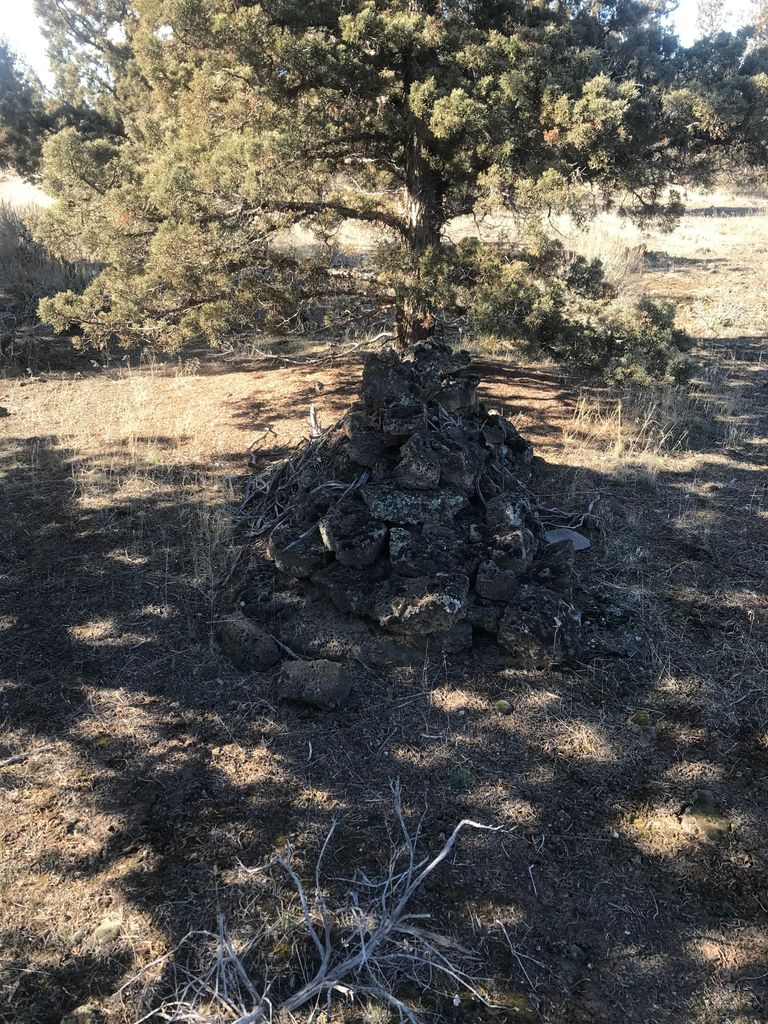
| Description | : | According to the records of the Meek Research Expedition, the Cooley and Tetherow Companies of the Lost Meek Wagon Train of 1845 crossed the Deschutes River at Cline Falls, not at Bend as has previously been believed. Directly along the path of their route, a pile of rocks that the Expedition members believe to be an unmarked grave was found. The pile, several feet long, could cover a human body. "Years ago, Del Hinshaw located this gravesite and associated it with Meek. From Cooley's mileage records, we infer that his party camped several miles northwest of... Read More |
frequently asked questions (FAQ):
-
Where is Cooley-Tetherow Meek Cutoff Lone Burial Site?
Cooley-Tetherow Meek Cutoff Lone Burial Site is located at Redmond, Deschutes County ,Oregon ,USA.
-
Cooley-Tetherow Meek Cutoff Lone Burial Site cemetery's updated grave count on graveviews.com?
0 memorials
-
Where are the coordinates of the Cooley-Tetherow Meek Cutoff Lone Burial Site?
Latitude: 44.2246700
Longitude: -121.2066700
Nearby Cemetories:
1. Redmond Memorial Cemetery
Redmond, Deschutes County, USA
Coordinate: 44.2449989, -121.2016983
2. Tumalo Cemetery
Tumalo, Deschutes County, USA
Coordinate: 44.1652985, -121.3181000
3. Deschutes Memorial Gardens
Bend, Deschutes County, USA
Coordinate: 44.1183014, -121.2906036
4. Terrebonne Pioneer Cemetery
Terrebonne, Deschutes County, USA
Coordinate: 44.3486100, -121.1502800
5. Pilgrims Rest Cemetery
Powell Butte, Crook County, USA
Coordinate: 44.2038400, -121.0271400
6. Greenwood Cemetery
Bend, Deschutes County, USA
Coordinate: 44.0569000, -121.2866974
7. Pilot Butte Cemetery
Bend, Deschutes County, USA
Coordinate: 44.0525360, -121.2886150
8. Trinity Episcopal Church Columbarium
Bend, Deschutes County, USA
Coordinate: 44.0558840, -121.3178980
9. Cyrus Cemetery
Cloverdale, Deschutes County, USA
Coordinate: 44.2693500, -121.4727000
10. Lost Immigrant Grave
Alfalfa, Deschutes County, USA
Coordinate: 44.0601578, -121.0321198
11. McCoin Orchard Grave Site
Opal City, Jefferson County, USA
Coordinate: 44.4284000, -121.0888100
12. Camp Polk Cemetery
Cloverdale, Deschutes County, USA
Coordinate: 44.3231010, -121.5139008
13. Gray Butte Cemetery
Culver, Jefferson County, USA
Coordinate: 44.4626007, -121.0992966
14. Saint Winefrides Garden
Sisters, Deschutes County, USA
Coordinate: 44.2922940, -121.5674410
15. Juniper Haven Cemetery
Prineville, Crook County, USA
Coordinate: 44.3153000, -120.8471985
16. Dehler Grizzly Mountain Cemetery
Prineville, Crook County, USA
Coordinate: 44.4251800, -120.9356100
17. Lost Meek Rimrock Springs Burial Site
Grizzly, Jefferson County, USA
Coordinate: 44.4954450, -121.0546000
18. Grandview Cemetery
Jefferson County, USA
Coordinate: 44.4944000, -121.3707962
19. Culver IOOF Cemetery
Culver, Jefferson County, USA
Coordinate: 44.5344009, -121.1691971
20. Grizzly Cemetery
Jefferson County, USA
Coordinate: 44.4902992, -120.9332962
21. Methodist Hill Cemetery
Metolius, Jefferson County, USA
Coordinate: 44.5639000, -121.2091980
22. Annie Cleek Burial Site
Grizzly, Jefferson County, USA
Coordinate: 44.5096230, -120.9429640
23. Roberts Cemetery
Crook County, USA
Coordinate: 44.0755997, -120.6875000
24. Mill Creek Cemetery
Crook County, USA
Coordinate: 44.3208008, -120.6611023