
| Memorials | : | 0 |
| Location | : | Coquille, Coos County, USA |
| Coordinate | : | 43.2078940, -124.1567270 |
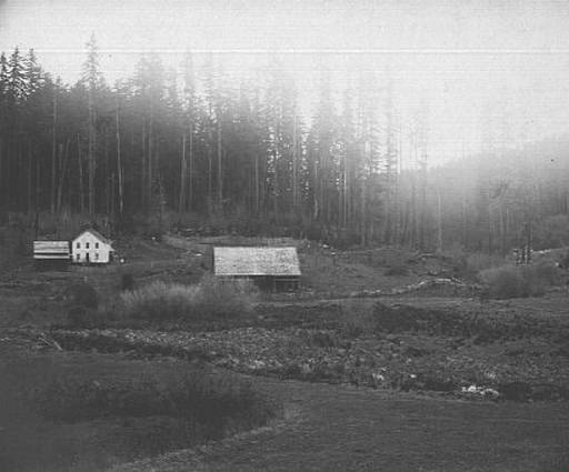
| Description | : | Location of the cemetery is unknown, but the farm was said to be towards Fairview from Coquille. The 1892 photo of the Coos County Poor Farm, to the right (courtesy Salem Public Library Historic Photograph Collections, Salem Public Library, Salem, Oregon), states the farm was near Empire City, now part of Coos Bay. Deaths reported in the Coquille Valley Sentinel state that there were burials on the farm property. |
frequently asked questions (FAQ):
-
Where is Coos County Poor Farm Cemetery?
Coos County Poor Farm Cemetery is located at Coquille, Coos County ,Oregon ,USA.
-
Coos County Poor Farm Cemetery cemetery's updated grave count on graveviews.com?
0 memorials
-
Where are the coordinates of the Coos County Poor Farm Cemetery?
Latitude: 43.2078940
Longitude: -124.1567270
Nearby Cemetories:
1. Coquille Pioneer Cemetery
Coquille, Coos County, USA
Coordinate: 43.1894120, -124.1951130
2. Masonic Cemetery
Coquille, Coos County, USA
Coordinate: 43.1868540, -124.1943520
3. Coquille IOOF Pioneer Cemetery #1
Coquille, Coos County, USA
Coordinate: 43.1802377, -124.1912000
4. IOOF Cemetery #1
Coquille, Coos County, USA
Coordinate: 43.1802266, -124.1913498
5. Fairview Cemetery
Fairview, Coos County, USA
Coordinate: 43.2089005, -124.0888977
6. Myrtle Crest Memorial Gardens
Coquille, Coos County, USA
Coordinate: 43.1596985, -124.1761017
7. Norris-Barker Cemetery
Coos County, USA
Coordinate: 43.2332993, -124.0916977
8. Sumner Pioneer Cemetery
Coos County, USA
Coordinate: 43.2750015, -124.1397018
9. Fox Bridge Cemetery
Coos County, USA
Coordinate: 43.1375008, -124.1027985
10. Robison-Lower Fishtrap Cemetery
Arago, Coos County, USA
Coordinate: 43.1232986, -124.2007980
11. Haynes Cemetery
Coos County, USA
Coordinate: 43.2943993, -124.1971970
12. Mast Cemetery
McKinley, Coos County, USA
Coordinate: 43.1886559, -124.0274048
13. Norway Cemetery
Norway, Coos County, USA
Coordinate: 43.1035995, -124.1552963
14. Gravelford Pioneer Cemetery
Gravelford, Coos County, USA
Coordinate: 43.1087530, -124.0890310
15. Hansen-Culbertson Cemetery
Gravelford, Coos County, USA
Coordinate: 43.1105800, -124.0721900
16. Upper Fish Trap Cemetery
Coos County, USA
Coordinate: 43.1074690, -124.2352010
17. Rackleff Cemetery
Myrtle Point, Coos County, USA
Coordinate: 43.0808400, -124.1454200
18. Dora Cemetery
Dora, Coos County, USA
Coordinate: 43.1554900, -123.9963200
19. Lampa Creek Cemetery
Coos County, USA
Coordinate: 43.1152992, -124.2861023
20. Sunset Memorial Park
Coos Bay, Coos County, USA
Coordinate: 43.3394012, -124.2003021
21. Russell Cemetery
Coos County, USA
Coordinate: 43.1763992, -124.3375015
22. Smalley Cemetery
Myrtle Point, Coos County, USA
Coordinate: 43.0776900, -124.2176000
23. Archer Cemetery
Coos County, USA
Coordinate: 43.3460999, -124.1877975
24. Hultin Thrush Cemetery
Coos County, USA
Coordinate: 43.1692009, -124.3494034