
| Memorials | : | 3 |
| Location | : | Arago, Coos County, USA |
| Coordinate | : | 43.1232986, -124.2007980 |
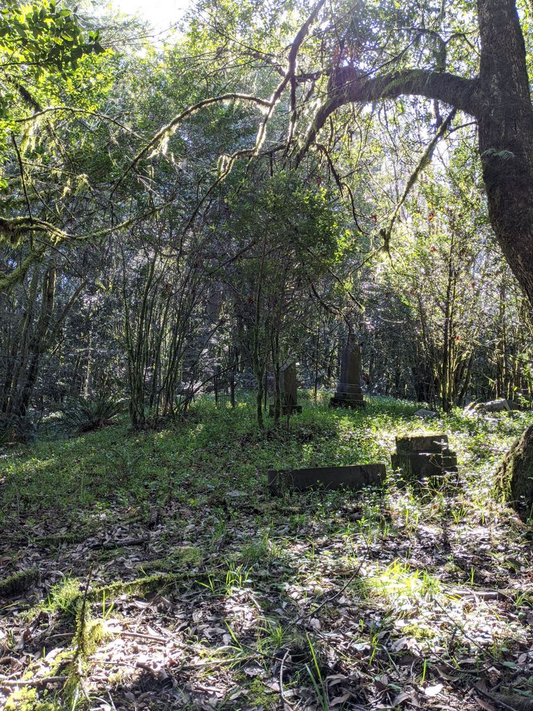
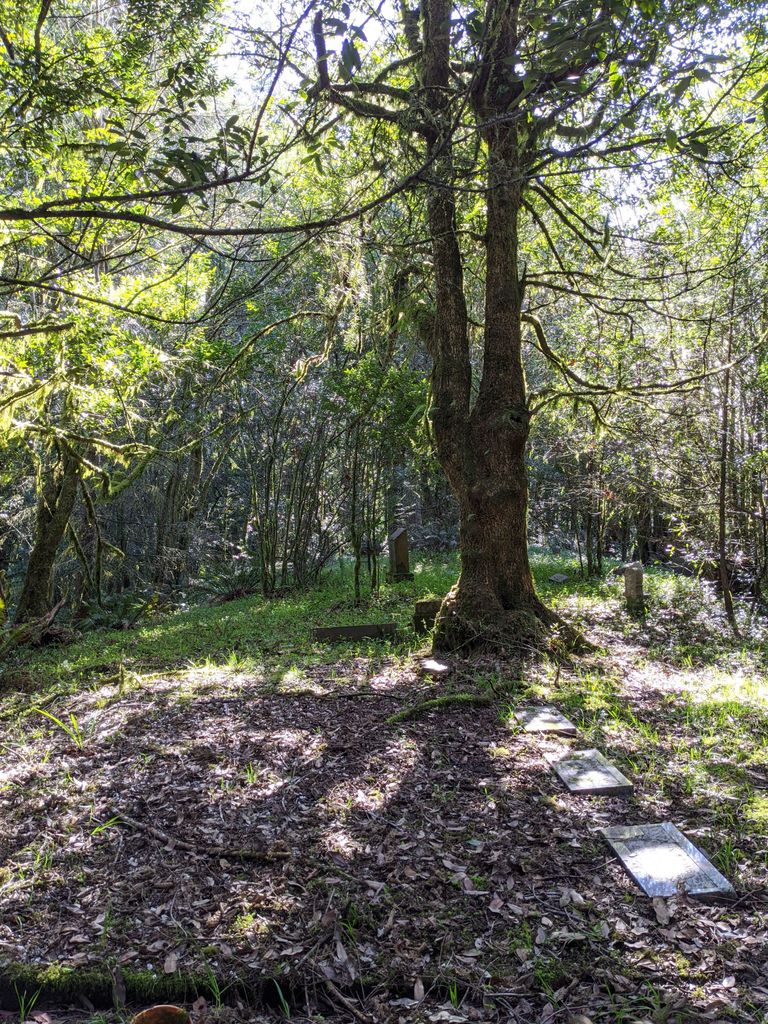
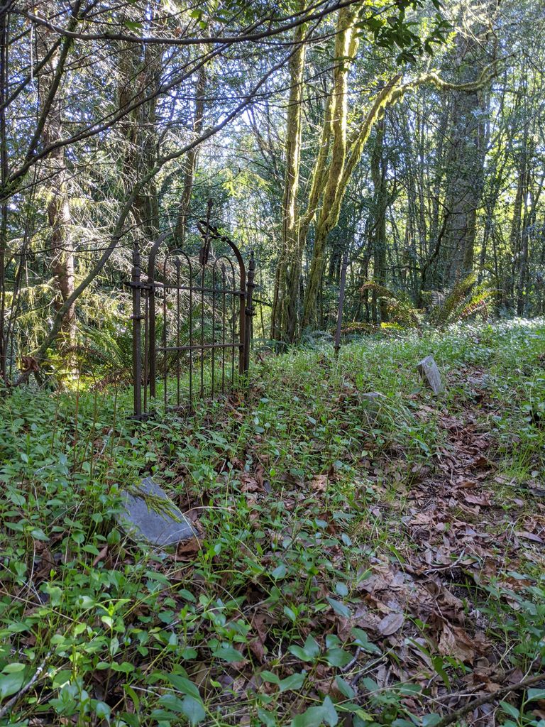
| Description | : | This cemetery is located on the top of a hill. You must walk up the hill as there is no road. The cemetery is not marked by a sign and is very overgrown. Located past Arago, Coos County, Oregon, using Lower Fishtrap Rd. |
frequently asked questions (FAQ):
-
Where is Robison-Lower Fishtrap Cemetery?
Robison-Lower Fishtrap Cemetery is located at Arago, Coos County ,Oregon ,USA.
-
Robison-Lower Fishtrap Cemetery cemetery's updated grave count on graveviews.com?
3 memorials
-
Where are the coordinates of the Robison-Lower Fishtrap Cemetery?
Latitude: 43.1232986
Longitude: -124.2007980


Nearby Cemetories:
1. Upper Fish Trap Cemetery
Coos County, USA
Coordinate: 43.1074690, -124.2352010
2. Norway Cemetery
Norway, Coos County, USA
Coordinate: 43.1035995, -124.1552963
3. Myrtle Crest Memorial Gardens
Coquille, Coos County, USA
Coordinate: 43.1596985, -124.1761017
4. Smalley Cemetery
Myrtle Point, Coos County, USA
Coordinate: 43.0776900, -124.2176000
5. IOOF Cemetery #1
Coquille, Coos County, USA
Coordinate: 43.1802266, -124.1913498
6. Coquille IOOF Pioneer Cemetery #1
Coquille, Coos County, USA
Coordinate: 43.1802377, -124.1912000
7. Rackleff Cemetery
Myrtle Point, Coos County, USA
Coordinate: 43.0808400, -124.1454200
8. Lampa Creek Cemetery
Coos County, USA
Coordinate: 43.1152992, -124.2861023
9. Masonic Cemetery
Coquille, Coos County, USA
Coordinate: 43.1868540, -124.1943520
10. Coquille Pioneer Cemetery
Coquille, Coos County, USA
Coordinate: 43.1894120, -124.1951130
11. Fox Bridge Cemetery
Coos County, USA
Coordinate: 43.1375008, -124.1027985
12. Gravelford Pioneer Cemetery
Gravelford, Coos County, USA
Coordinate: 43.1087530, -124.0890310
13. Myrtle Point Cemetery
Myrtle Point, Coos County, USA
Coordinate: 43.0639000, -124.1196976
14. Coos County Poor Farm Cemetery
Coquille, Coos County, USA
Coordinate: 43.2078940, -124.1567270
15. Hansen-Culbertson Cemetery
Gravelford, Coos County, USA
Coordinate: 43.1105800, -124.0721900
16. Bear Creek Cemetery
Coos County, USA
Coordinate: 43.1055984, -124.3319016
17. Hoffman Cemetery
Myrtle Point, Coos County, USA
Coordinate: 43.0402300, -124.1152400
18. Garrett Cemetery
Coos County, USA
Coordinate: 43.0405998, -124.1144028
19. Parkersburg Cemetery
Coos County, USA
Coordinate: 43.1413330, -124.3444110
20. Whittington Cemetery
Myrtle Point, Coos County, USA
Coordinate: 43.0222783, -124.1486533
21. Warner Cemetery
Coos County, USA
Coordinate: 43.0250015, -124.1280975
22. Russell Cemetery
Coos County, USA
Coordinate: 43.1763992, -124.3375015
23. Catching Creek Cemetery
Coos County, USA
Coordinate: 43.0080986, -124.2130966
24. Hultin Thrush Cemetery
Coos County, USA
Coordinate: 43.1692009, -124.3494034